Download

1 / 39
520 likes | 1.1k Vues
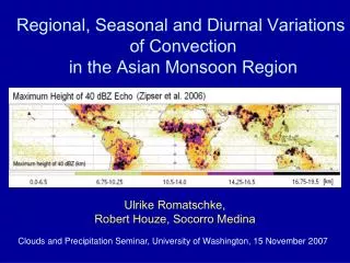
Diurnal variations of rainfall and winds over Malaysia. Sandra Richard and Yi-Leng Chen November 2, 2010 National Central University Chungli, Taiwan. INTRODUCTION. Malaysia : West Malaysia (Peninsular Malaysia/Malaya) East Malaysia (Borneo). INTRODUCTION. 8 N. EQ. 95 E. 125 E.

E N D
Diurnal variations of rainfall and winds over Malaysia Sandra Richard and Yi-Leng Chen November 2, 2010 National Central University Chungli, Taiwan
INTRODUCTION • Malaysia : • West Malaysia (Peninsular Malaysia/Malaya) • East Malaysia (Borneo)
INTRODUCTION 8N EQ 95E 125E Fig. 1 : Southeast Asia Map
4000 2000 SABAH 1000 BRUNEI 500 0 SARAWAK KALIMANTAN Fig. 2: Topography of East Malaysia (Borneo)
Straits of Malacca Northern Sumatera Fig. 3: Topography of West Malaysia (Peninsular/Malaya)
GENERAL CLIMATE OF MALAYSIA • Uniform temperature (33C), high humidity and copious rainfall • 4 seasons can be distinguished : • Northeast (early Nov – March) • Southwest (mid May/Early June – Sept) • Two shorter periods of inter-monsoon (www.met.gov.my)
PREVIOUS STUDIES • Previous studies on diurnal rainfall variations over the Southeast Asia/Malaysia region have been done using : i) station observations - Ramage (1964) - Nieuwolt (1966 and 1967) • Houze (1981) • Oki & Musiake (1994) ii) satellite data (TRMM, GOES) and radar data - Ichikawa & Yasunari (2006) - Kikuchi & Wang (2008) iii) WRF model - Fujita & Kimura (2010)
Main findings from previous studies • 1) Kikuchi and Wang (2008) • Studied the diurnal variations of the global tropical precipitation (TRMM). • Amplitude of the diurnal cycle is dependent on season but the phase characteristics are not. • 2) Ramage (1964) • Studied the diurnal variation of rainfall over West Malaysia during summer using station data. • 5 regimes: South West coast – Malacca Straits, West Coast, Inland – mountain, Mountain – valley, East coast. • Due to interactions among local winds, synoptic winds and orography.
Main findings from previous studies 3) Houze et. al. (1981) • Examined the genesis of nocturnal rainfall near the northwestern coast of Borneo during NE monsoon. • Convergence between land breezes and northeasterlies generated offshore convection, which developed into an organized precipitation system with heavy rainfall during midnight to morning.
MOTIVATION • The diurnal cycle is important in controlling the local weather. • Diurnal rainfall and local wind variation under different seasons is important for forecasting purposes. • The variation of diurnal rainfall under different seasons, with different large-scale conditions, has not been investigated in sufficient detail before. • Most studies have shown the diurnal rainfall variation but have not shown local wind analysis.
OBJECTIVE • To make full use of the available station observations, particularly wind observations, in analyzing the observed rainfall variations. • Diurnal rainfall variation may depend on the interaction between the prevailing flow, local winds, orographic lifting (by combined prevailing flow/local winds), orographic blocking and instability. • A comprehensive study of diurnal variations in rainfall and winds according to their seasonality is proposed.
DATA & METHODS • NCEP/NCAR Reanalysis 1 (2.5 x 2.5) : • Monthly mean winds (1968 – 1996 ) at 925-hPa, 500-hPa and 250-hPa for January, April, July and October. • NCEP FNL Reanalysis (2.5 x 2.5): • Half-monthly means (2003-2008) for winds (925-hPa, 500-hPa and 250-hPa), PW and moist static energy profiles at 3 points (5N 99E, 5N 105E, 4N 111E). • From QuikSCAT (0.5 x 0.5) • Half-monthly mean (2003-2008) for near-surface winds over the ocean.
DATA & METHODS (cont…) • Daily and 3-h TRMM 3B42 dataset, 0.25X0.25), • Half-monthly (2003-2008) TRMM mean rainfall. • Rainfall from station observations (2003-2008) • Half-monthly mean rainfall from station observations. • Half-monthly means of hourly rainfall and frequency from station observations. • Surface winds from station observations (2003-2008) • Half-monthly means for surface winds at selected hours for selected rainy periods.
m Fig.4 : Malaysia Meteorological Department principal stations.
(a) JANUARY 925-hPa (b) APRIL 925-hPa (c) JULY 925-hPa (d) OCTOBER 925-hPa Fig. 5 : Long-term (1946-2008) mean 925-Pa wind for (a) January, (b) April, (c) July and (d) October. Wind speed (m s-1) is indicated as dotted line.
(b) (a) (d) (c) m s-1 Fig. 6 The near surface half-monthly mean winds for selected periods during the NE monsoon season. Wind speed (m s-1) indicated in colors.
(c) (d) mm d-1 Fig. 7: TRMM half-monthly mean rainfall (mm d-1) for selected periods during the NE monsoon season as observed by TRMM satellite.
(d) IM/fall (08 LT) (c) SW (08 LT) (a) NE (08 LT) (b) IM/spring (08 LT) 16 08LT 08LT 08LT 08LT 08LT 16 (h) IM/fall (17 LT) (g) SW (17 LT) (e) NE (17 LT) (f) IM/spring (17 LT) 17LT 16 (17LT) 17LT 17LT 17LT mm h-1 Fig. 8: The TRMM 3-hourly mean rainfall (mm h-1) at 0800 LT and 1700 LT for each rainy period during the different monsoon seasons.
(d) IM/fall (c) SW (a) NE (b) IM/spring m s-1 (h) IM/fall (g) SW (e) NE (f) IM/spring kg m-2 Fig. 9: The near-surface mean winds (top) and total PW (bottom) for each rainy period during the different monsoon seasons.
LAND/SEA BREEZES (d) IM/Fall (08 LT) (b) IM/Spring (08 LT) (a) NE (08 LT) (c) SW (08 LT) (d) IM/Fall (17 LT) (b) IM/Spring (17 LT) (c) SW (17 LT) (a) NE (17 LT) Fig. 10: The mean surface winds at 0800 LT (top) and 1700 LT (bottom) for each rainy period during the different monsoon seasons. Half barb (0.5 m s-1), full barb (1.0 m s-1).
(a) Rainfall amount (mm h-1) (b) Rainfall frequency (%) Fig. 11 : The half-monthly mean rainfall amount (mm h-1) and frequency (%) for the southwest coast of East Malaysia.
(a) Rainfall amount (mm h-1) (b) Rainfall frequency (%) Fig. 11 : The half-monthly mean rainfall amount (mm h-1) and frequency (%) for the northeast coast of East Malaysia.
(d) IM/fall (05 LT) (h) IM/fall (17 LT) (c) SW (05 LT) (g) SW (17 LT) (a) NE (05 LT) (e) NE (17 LT) (b) IM/spring (05 LT) (f) IM/spring (17 LT) mm h-1 Fig. 12: The TRMM 3-hourly mean rainfall (mm h-1) at 0500 LT and 1700 LT for each rainy period during the different monsoon seasons.
(d) IM/fall (05 LT) (c) SW (05 LT) (a) NE (05 LT) (b) IM/spring (05 LT) (h) IM/fall (17 LT) (g) SW (17 LT) (e) NE (17 LT) (f) IM/spring (17 LT) Fig. 13: The mean surface winds at 0500 LT (top) and 1700 LT (bottom) for each rainy period during the different monsoon seasons. Half barb (0.5 m s-1), full barb (1.0 m s-1).
(d) IM/fall (05 LT) (c) SW (05 LT) (a) NE (05 LT) (b) IM/spring (05 LT) (h) IM/fall (g) SW (e) NE (f) IM/spring 05 LT) m s-1 kg m-2 Fig. 14: The near-surface mean winds (top) and total PW (bottom) for each rainy period during the different monsoon seasons.
Diurnal rainfall regions: • Northwest coast • Southwest coast • Western Central Mountain • Inland-valley • East coast (a) (e) (c) (d) (b) Fig. 15 : Diurnal rainfall region over West Malaysia
(a) Rainfall Amount (mm h-1) for the northwest coast region (b) Rainfall Frequency (%) for the northwest coast region Fig. 3.16 : The half-monthly mean rainfall amount (mm h-1) and frequency (%) for the northwest coast region over West Malaysia.
(a) Rainfall Amount (mm h-1) for the southwest coast region (b) Rainfall Frequency (%) for the southwest coast region Fig. 3.17 : The half-monthly mean rainfall amount (mm h-1) and frequency (%) for the southwest coast region over West Malaysia.
(a) Rainfall Amount (mm h-1) for the west Central Mountain region (h) Rainfall Frequency (%) for the west Central Mountain region Fig. 3.17 : The half-monthly mean rainfall amount (mm h-1) and frequency (%) for the west Central Mountain region over West Malaysia.
(a) Rainfall Amount (mm h-1) for the east coast region (b) Rainfall Frequency (%) ) for the east coast region Fig. 3.18 : The half-monthly mean rainfall amount (mm h-1) and frequency (%) for the east coast region over West Malaysia.
(a) Rainfall Amount (mm h-1) for the inland-valley region (b) Rainfall Frequency (%) ) for the inland-valley region Fig. 3.19 : The half-monthly mean rainfall amount (mm h-1) and frequency (%) for the inland-valley West Malaysia.
EARLY MORNING (NORTHEAST MONSOON) Fig. 22 : Conceptual model of downslope winds-land breezes (red arrows) and prevailing flow (blue arrows) during NE monsoon season over Malaysia. Diagrams are not drawn in scales.
DAY TIME (NORTHEAST MONSOON) Fig. 23 : Conceptual model of upslope winds–sea breezes (red arrows) and prevailing flow (blue arrows) during NE monsoon season over Malaysia. Diagrams are not drawn in scales.
EARLY MORNING (SOUTHWEST MONSOON) Fig. 24 : Conceptual model of downslope winds-land breezes (red arrows) and prevailing flow (blue arrows) during SW monsoon season over Malaysia. Diagrams are not drawn in scales.
DAY TIME (SOUTHWEST MALAYSIA) Fig. 25 : Conceptual model of upslope winds - sea breezes system (red arrows) and prevailing flow (blue arrows) during SW monsoon season over Malaysia. Diagrams are not drawn in scales.
CONCLUSION • Rainfall distribution has large spatial variations with higher rainfall on the windward side especially during the winter northeast monsoon season. The timing of the heaviest rainy season occurs when the northeast monsoon has the largest impinging angle on the coastal mountain ranges. • The driest season occurs during the southwest monsoon season with low total precipitable water over the area and when the monsoon trough is farthest to the north over the South China Sea. • Land-sea breezes and/or upslope-downslope winds occurred throughout the year for most areas. • The timing of diurnal rainfall maximum and horizontal rainfall distribution are closely related to terrain, local winds and interaction of diurnal driven winds with the prevailing flow.
CONCLUSION • On the windward side, sea breezes/upslope winds combine with the prevailing flow result in a rainfall maximum during the late afternoon due to orographic lifting. • On the leeside, sea breezes/upslope winds result in a secondary rainfall maximum during the late afternoon. • Afternoon rainfall maximum mainly occurred near the foothills of the mountain ranges and propagate inland during late afternoon/early evening.
CONCLUSION • Over the northwest coast of East Malaysia, nocturnal rainfall is most significant during the late northeast monsoon season due to convergence of land breezes and northeasterly monsoon flow. • Over the east coast of West Malaysia, land breezes are evident except during the early northeast monsoon season under strong northeasterlies ( 7~8 m s-1). • Over the east coast of West Malaysia, nocturnal rainfall is most significant during the early northeast monsoon season due to orographic blocking of strong northeasterly monsoon flow. Flow deceleration of the incoming northeasterly monsoon flow is most significant in the early morning. • Throughout the year, convergence between land breezes and prevailing flow or between land breezes from both sides of the coast within the straits result in nocturnal rainfall over the coastal areas.
THANK YOU !!! QUESTIONS??? Mt. Kinabalu, Sabah April 04, 2006