Mapping Geologic Features and Land Use with Aerial Photographs
This activity involves marking geologic features and roads on the transparency overlay of a map. Utilize symbols and patterns to distinguish between different features. Create a key for these features, and if unsure, hypothesize what they may be. Aerial photographs are used to evaluate land use and assess conditions prior to site visits at research locations. Additionally, you will identify various geologic features, such as Carolina bays, and update your map key as new information is received.

Mapping Geologic Features and Land Use with Aerial Photographs
E N D
Presentation Transcript
Activity • Mark any geologic features, roads, etc. that you see on the transparency over your map. Use symbols or different patterns to indicate different features. • Make a key of these features. If you aren’t sure what a feature is, make a hypothesis.
I use aerial photographs • To evaluate land use • To assess conditions before site visits
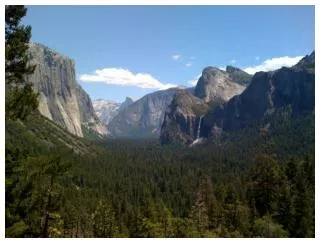
Some of my research sites!
Identify geologic features • As you are given new information, make corrections to your map key.