Enhancing Ocean Monitoring with Automated SVP Server: A Leap in Marine Data Collection
Discover how the SVP Server revolutionizes data collection in oceanography by automating temperature and salinity profile extraction from the 2009 World Ocean Atlas (Levitus) without operator intervention. Our technology streamlines the process of delivering T/S profiles for ray bending corrections seamlessly. Data gathered during transit by CCGS Amundsen and USCGC Healy showcases the effectiveness of the SVP Server over multiple casts. Join us for a demo during the poster session to see our innovative ocean modeling in action, integrating real-time measurements for future advancements.

Enhancing Ocean Monitoring with Automated SVP Server: A Leap in Marine Data Collection
E N D
Presentation Transcript
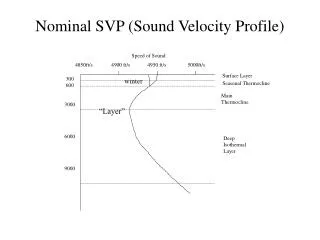
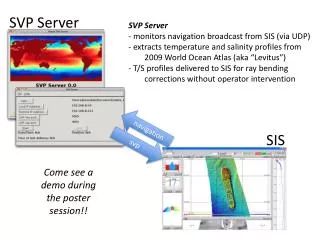
SVP Server • SVP Server • monitors navigation broadcast from SIS (via UDP) • extracts temperature and salinity profiles from 2009 World Ocean Atlas (aka “Levitus”) • T/S profiles delivered to SIS for ray bending corrections without operator intervention SIS Come see a demo during the poster session!! navigation svp
SVP Server Beta Testers CCGS Amundsen 2011 return transit to Quebec city USCGC Healy 2011 return transit to Dutch Harbor SVP Server provided 68 SVP casts over 8 day transit SVP Server provided 57 SVP casts over 5 day transit (note WOA2009/Levitus has 1° grid resolution) Thanks to Steve Roberts (UCAR) Thanks to Steve Brucker (OMG/UNB)
Global Real-Time Ocean Forecast System (RTOFS) NOAA National Weather Service Environmental Modeling Center Future Plans http://polar.ncep.noaa.gov/global/ • Incorporate in situ measurements • Consistent and streamlined XBT/CTD pre-processing • Automated upload and application in SIS • More sophisticated oceanographic models “This system is based on an eddy resolving 1/12° global HYCOM (HYbrid Coordinates Ocean Model) and is part of a larger national backbone capability of ocean modeling at the National Weather Service in a strong partnership with the US Navy.”