, CENTRAL ETHIOPIA
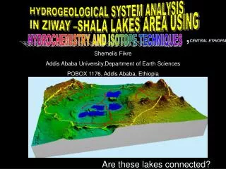
HYDROGEOLOGICAL SYSTEM ANALYSIS . IN ZIWAY –SHALA LAKES AREA USING . , CENTRAL ETHIOPIA. HYDROCHEMISTRY AND ISOTOPE TECHNIQUES. Shemelis Fikre Addis Ababa University,Department of Earth Sciences POBOX 1176, Addis Ababa, Ethiopia. Are these lakes connected?.

, CENTRAL ETHIOPIA
E N D
Presentation Transcript
HYDROGEOLOGICAL SYSTEM ANALYSIS IN ZIWAY –SHALA LAKES AREA USING ,CENTRAL ETHIOPIA HYDROCHEMISTRY AND ISOTOPE TECHNIQUES Shemelis Fikre Addis Ababa University,Department of Earth Sciences POBOX 1176, Addis Ababa, Ethiopia Are these lakes connected?
Objectives • Conceptualize the groundwater flow system in the area • Identify the subsurface hydraulic connections of the lakes in the area • Investigate the correspondence between spatial locations and statistical groups. • Assess surface water- groundwater interactions in the lake watershed system. • Conceptualize the role of geological structures on the groundwater movement
Methodology • Sampling and laboratory analysis • Hydrochemicaltechniques • Physico – chemical analysis • Statistical cluster analysis (HCA) and distributions of the clusters • Isotope techniques • 18O, 2H and 3H are analysed using plots for samples from the different water bodies • Both hydrochemical and isotope techniques together • Scatter plots for the values of 18O versus EC, 18O versus chloride, tritium versus EC and tritium versus chloride are prepared and interpreted • Spatial variation of isotopes in relation with hydrochemistry using maps
Hydrogeology 1= Ignimbrite, tuff, local rhyolite 2= Ignimbrite, tuff, local basalt 3= Ignimbrite covered with lacustrine soils, recent regression 4= Ignimbrite covered with lacustrine deposit 5= Rift volcanoes and volcanic ridges 6= Basalt, local ignimbrite 7= Lake 8= Volcano-tectonic structures 9= Drainage 10=Groundwater level contour 11=Cold spring 12=Hot spring 13=Groundwater flow direction, Circles represent the Hydraulic conductivity.
Hydrogeological System Analysis Groundwater Lake waters The locations of sampling sites Using Hydrochemistry Data • Physico – chemical analysis • Major ion variability
Groundwater flow direction Major ion chemistry ………..
Escarpment Highland Water types and physiography
Electrical conductivity • There are clear zonations in EC of natural waters following the rift ward directions
Statistical analysis… • Spatial distribution and chemical differences of the HCA derived subgroups for groundwaters
1 Chemical Evolution Path-From the recharge areas to discharge areas 4 2 3 Note:- Represents direction of anion and cation dominance in groundwaters and lake waters along flow path from recharge to discharge area Hydrochemical evolutions and groundwater flow Groundwater-lake water interactions • Starting from highland and escarpment waters and ending with rift floor waters; 1234. Total dissolved solids (TDS) concentration increases with increasing subgroup number
Hydrogeological System Analysis Using Isotope Data Deuterium (2H) and oxygen(18O ) isotope sampling sites for isotope analysis:-
Deuterium (2H) and oxygen(18O ) isotopes • The LMWL is plotted above the GMWL this is due to the isotopic concentrations of precipitation in the study area has more deuterium excess (that is D excess=2.35) than the global averaged precipitations. • The majority of groundwaters, river waters and rain waters are plotted near the LMWL .This indicate the importance of present day precipitation for groundwater recharge. • The lake Waters are plotted far to the right and shifted right down of the LMWL .This shows that the lakes are more enriched with 18O and 2Hresulted from substantial evaporative loss of the lake waters as compared to the present day precipitation . • Groundwaters (waters from hot spring, cold springs, cold wells, and geothermal wells) are scattered at different positions on the plot and have differences in 18O and 2H concentrations.
Both hydrochemistry and isotopes together The relations between 18O with Cl • The relations between 18O with EC
The relations between 18O with EC … • The cold spring waters have negative 18O constituents and low EC similar to the rivers( except Bulbula and Horakelo) indicates that they are rechrged by shallow circulating groundwaters which have undergone little rock- water interactions.Groundwater flows from lake Ziway to lake Langano • The source of some hot springs is surface waters and shallow groundwaters. The relations between 18O with Cl ... • The lake water labeled c12 (lake Ziway) has similar chloride concentration with c9 (lake Langano) but the 18O enrichment in c9 is higher than c12.This is due to the high evaporation water loss from lake Langano. From this it is evidence to conclude that there is southward migration of lake Ziway waters towards lake Langano • The geothermal water labeled f19 has similar 18O enrichment but higher Cl concentration than lake Ziway waters (labeled c12).Lake waters labeled c13 has also similar 18O enrichment and Cl concentrations with the geothermal water labeled f20. This shows that there is dilution of the geothermal water by the lake Ziway water. From this it is evidence to conclude that there is mixing of the lake waters with the geothermal waters.
Tritium versus EC Tritium versus Chloride • The borehole waters near the lakes have similar EC and tritium values to the lake waters indicating the interaction of the lake waters with the surrounding groundwaters. • Boreholes near the geothermal system has higher EC and lower tritium values may indicate mixing • The lake Ziway water shows a decrease in tritium content and chloride concentration with time indicates the decrease in the amount of surface inflow in to the lake
Spatial variation of isotopes in relation with hydrochemistry symbol label begins with “a” are cold spring, with “d” are rain and “e” are river samples
CONCLUSIONS • The high spatial ionic variations follows systematic trend. This reflects the different groundwater flow systems and the existence of hydrochemical evolution of waters along the flow path • On the highlands and escarpments there is shallow circulation of groundwaters from direct recharge of precipitation and these waters have undergone no marked rock-water interactions. • The low EC & TDS and isotope depleted waters in highly faulted rift waters which have similarity in EC, TDS and depletion with the highland and escarpment waters indicates the southward migration of highland and escarpment waters through faults and finally to lake Langano. The tectonic structures play a great role on the groundwater flow and chemical evolution • There is deeper groundwater circulation of old age on the highly faulted areas
CONCLUSIONS…… • The lake waters, the majority of the groundwaters and surface waters have similar tritium contents. This shows that these waters have similar recharge source. • Tritium contents of water from deep wells and hot springs are different from lake waters indicates they have different sources • Groundwaters north of lake Langano have similar 18O content with the lake Ziway waters may show that there is subsurface hydraulic connection between lake Ziway and lake Langano • The chemical composition of borehole waters between lake Abiyata and Langano is similar for the nearby lake waters. This shows that there is flow of waters from lake Langano to lake Abiyata along the NE-SW trending fault