Download
1 / 15
150 likes | 169 Vues
Gain insights on GIS in the region, assess agency capabilities and data, track regional growth, establish a GIS baseline for homeland security, and explore past surveys. Discover key improvements highlighted by responding agencies.

E N D
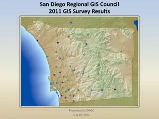
San Diego Regional GIS Council Local Agency GIS Survey 2006 Summary of Survey Results
SDRGC Local Agency GIS Survey 2006 Develop understanding of GIS in the region Identify capabilities and knowledge available Understand GIS data maintained by agencies Look at region’s growth and transformation Regional GIS baseline for homeland security Past surveys 1995, 1997, 2001 On-line survey through Survey Monkey Grown to meet changing environment Questions developed from other surveys Total of 88 questions
Who Took the Survey • GIS Managers from public agencies • 34 agencies responded • 2 agencies do not currently use GIS • 2 agencies only provided contact information • Response totals for each question varies
GIS Community Mature GIS community In 2006 survey • 57% have 10+ years of experience • Another 17% have between 5-9 years of experience
GIS Community Most agencies use two or more databases
GIS Data 80% maintain additional data outside of SanGIS 90+ data themes maintained by agencies Appendix 5 – Categorized list of layers and agency Metadata • 57% maintain metadata on the layers • Of those 50% meet the minimum FGDC requirements
Geospatial Assistance Please rank the importance of these improvements to your agency's GIS with 1 being the highest importance and 10 the lowest. (Report data indicates percentage of responding agencies that ranked each item in their top 5.) Improve maintenance (data updates) 72% Hire staff 71% Build additional layers 65% Design a system architecture for enterprise GIS 63% Implement applications 56% Increase accuracy 56% Hire consultants 41% Train staff 39% Create interjurisdictional GIS layers or regional layers 33% Acquire hardware, software, or communication systems for data 31%
Geospatial Assistance 70% Access to data 26% helpful to have agency’s data stored on a central server hosted by another agency
Summary • Mature GIS community • ESRI software is the standard in the region • Most agencies rely on SanGIS geospatial layers • Most agencies maintain additional data outside of SanGIS • Metadata is the weakest link in the community • Geospatial data is being used for many applications in many departments • Areas where additional funding could help • Improve data maintenance • Build additional layers • Data access • Additional staffing
The Report • Executive Summary • Respondents Information • Question Responses by Agency • Appendices • Software Usage Tables • GIS Applications Table • Inter/Intra-net Applications • Coordinate Systems Table • Layers Maintained by Agency • Geospatial Assistance Table • Contact Information www.SDRGC.org