Download

1 / 8
80 likes | 178 Vues
Explore details of the magnitude 3.8 earthquake in Wales, UK on May 29, 2013, including its location, impact, historic seismicity, and tectonic interpretation. Learn about seismogram recordings and aftershocks.

E N D
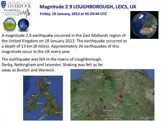
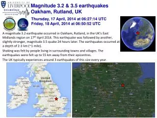
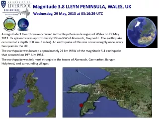
Magnitude 3.8 LLEYN PENINSULA, WALES, UK Wednesday, 29 May, 2013 at 03:16:29 UTC A magnitude 3.8 earthquake occurred in the Lleyn Peninsula region of Wales on 29 May 2013. Its epicentre was approximately 13 km NW of Abersoch, Gwynedd. The earthquake occurred at a depth of 8 km (5 miles). An earthquake of this size occurs roughly once every two years in the UK. The earthquake was located approximately 21 km WSW of the magnitude 5.4 earthquake that occurred on 19th July 1984. The earthquake was felt most strongly in the towns of Abersoch, Caernarfon, Bangor, Holyhead, and surrounding villages. N
Magnitude 3.8 LLEYN PENINSULA, WALES, UK Wednesday, 29 May, 2013 at 03:16:29 UTC Where was it felt? Most shaking was felt within a 50 km radius of the epicentre. Maximum recorded intensity ofIV (moderate shaking) in surrounding settlements of Abersoch and Caernarfon. Weak shaking was felt as far away as Conwy, Rhyl, Southport (Merseyside) and on the Isle of Man. 10 km Location of shaking reports (image courtesy BGS) Modified Mercalli Intensity Scale
Magnitude 3.8 LLEYN PENINSULA, WALES, UK Wednesday, 29 May, 2013 at 03:16:29 UTC Earthquake and historic seismicity The earthquake epicentre (red star) is plotted on the map with regional historic seismicity. Small earthquakes in this region of the UK are not unusual. The largest recorded earthquake in this region of the UK was a magnitude 5.4 event that occurred on 19th July 1984; its epicentre was located around 20km ENE of the M3.8 May 2013 earthquake. Historic recorded seismicity of the British Isles Historic seismicity in the region of the mainshock (image courtesy of BGS)
Magnitude 3.8 LLEYN PENINSULA, WALES, UK Wednesday, 29 May, 2013 at 03:16:29 UTC Tectonic interpretation Although the UK does not lie on an active tectonic plate boundary (one of its nearest plate boundaries being the Mid-Atlantic Ridge – located some 2000 km to the west), stress within the plate is released along pre-existing faults within the crust. Some of these ancient faults are generally not exposed at the surface (these are known as ‘blind faults’) and in areas of low seismicity, such as the British Isles, it is difficult to identify the causative fault. Furthermore, with such low-magnitude events, it is not possible to determine the earthquake’s precise mechanism. Alpine – Pyrenees mountain belt Mid-Atlantic Ridge Africa – Eurasia collision zone Map of major tectonic boundaries in Western Europe
Magnitude 3.8 LLEYN PENINSULA, WALES, UK Wednesday, 29 May, 2013 at 03:16:29 UTC Seismogram recordings from BGS network and locating the earthquake By finding the difference in arrival times between the P- and S-wave arrivals at different seismic stations, we can calculate the distance of the earthquake from each receiver (circles). If we do this for several stations (triangles), we can determine the approximate epicentre of the earthquake (orange star) by finding the common intersection point of these radii. You can plot seismograms like these yourself at www.iris.edu/wilber
Magnitude 3.8 LLEYN PENINSULA, WALES, UK Wednesday, 29 May, 2013 at 03:16:29 UTC Seismogram recordings from the UK School Seismometer Network DEOS (University of Liverpool) AGSB (Altrincham Grammar School for Boys), Greater Manchester
Magnitude 3.8 LLEYN PENINSULA, WALES, UK Wednesday, 29 May, 2013 at 03:16:29 UTC Aftershocks So far, only one aftershock has been recorded. This event with magnitude 1.7 (orange circle) occurred just 4 minutes after the mainshock (red star), and was located a few kilometers to the southwest. Further small aftershocks may be expected in the coming days and weeks.
Magnitude 3.8 LLEYN PENINSULA, WALES, UK Wednesday, 29 May, 2013 at 03:16:29 UTC • Find out more… • BGS (British Geological Survey) – seismology and earthquakes – frequently asked questions http://www.earthquakes.bgs.ac.uk/education/faqs/faq_index.html • IRIS (Incorporated Research Institutions for Seismology) – learning about earthquakes http://www.iris.edu/hq/programs/education_and_outreach/students • UK School Seismology Project – classroom activities, videos and support documents http://www.bgs.ac.uk/schoolseismology/home.html • USGS (United States Geological Survey) – FAQs, glossary, posters, animations http://earthquake.usgs.gov/learn/ • EMSC (European Mediterranean Seismological Centre) http://www.emsc-csem.org/