Download
1 / 1
10 likes | 260 Vues
Spatial Variability of Soil Properties in Southern Louisiana S. Johnson 1* , D. Weindorf 1 , M. Selim 1 , N. Bakr 1 , Y. Zhu 1 1 Louisiana State University AgCenter , Baton Rouge, LA. * Corresponding author: sjoh159@lsu.edu. a.). b.).

E N D
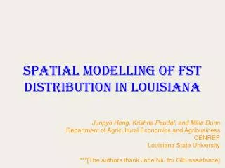
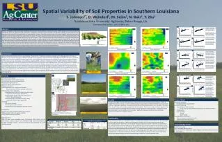
Spatial Variability of Soil Properties in Southern Louisiana S. Johnson1*, D. Weindorf1, M. Selim1, N. Bakr1, Y. Zhu1 1Louisiana State University AgCenter, Baton Rouge, LA. *Corresponding author: sjoh159@lsu.edu a.) b.) a.) R2 value for actual clay % compared to a predicted clay % from a kriging interpolation without elevation integration b.) R2 value for actual clay % compared to a predicted clay % from a spline interpolation without elevation integration c.) R2 value for actual clay % compared to a predicted clay % from a kriging interpolation with elevation integration d.) R2 value for actual clay % compared to a predicted clay % from a spline interpolation with elevation integration Abstract Clay % Clay % Nutrient and sediment runoff are major contributors to non-point source pollution of Louisiana bayous. Yet the dynamics of runoff are often site specific and based on physicochemical soil factors, topography, proximity to surface waters, etc. Spatial variability of soil properties across landscapes was studied on a 1.66 ha field in St. Landry Parish, Louisiana. This field is located ~130 m from Bayou Wikoff. The soils at this site are mapped as silt loam (Jeanerette, Frost, and Patoutville series). This field supports improved, fertilized pasture used for haying and livestock. The field has been historically modified with broad, low rise furrows. A total of 104 georeferenced surface samples (0-5 cm) were collected across the site in January 2009. Standard soil physicochemical analysis was performed in the lab, including pH, organic carbon (OC %), and clay %. Lab data was interpolated using ArcGIS kriging and spline techniques. Spatial variability of nutrient concentrations was examined. Results showed a high correlation between elevation and evaluated soil properties. Data from the study will be used to: 1) quantify the spatial distribution of soil physical and chemical properties using ArcGIS interpolation methods (kriging, inverse distance weighting, and spline) as a means of, 2) targeting specific best management practices to areas where surface water quality is poor due to suspended solids. Predicted Clay % kriging without elevation incorporation Predicted Clay % spline without elevation incorporation c.) d.) 3D view of clay % distribution using ArcScene at the study site in St. Landry Parish, LA Predicted Clay % Kriging with elevation incorporation Predicted Clay % kriging with elevation incorporation Predicted Clay % spline with elevation incorporation Clay % distribution with elevation using a kriging interpolation from the study site in St. Landry Parish, LA Clay % distribution with elevation using a spline interpolation from the study site in St. Landry Parish, LA a.) b.) a.) R2 value for actual OC % compared to a predicted OC % from a kriging interpolation without elevation integration b.) R2 value for actual OC % compared to a predicted OC % from a spline interpolation without elevation integration c.) R2 value for actual OC % compared to a predicted OC % from a kriging interpolation with elevation integration d.) R2 value for actual OC % compared to a predicted OC % from a spline interpolation with elevation integration OC % OC % Introduction Natural soil spatial variability occurs in any landscape. However, the introduction of elevation change, such as drainage swales, furrows, or terraces has the potential to produce additional variability of soil properties. Physicochemical analyses determine values for each soil property. These properties can be displayed spatially using ArcGIS. Several predictive modeling tools are available for describing soil spatial variability. For this study, we have used kriging, inverse distance weighting (IDW), and spline methods via ArcGIS. The IDW method is a technique where the values at unknown locations are proportional to their distance from locations with established data. The spline interpolation is a polynomial smoothing technique used to minimize sharp bends in continuous data. Kriging is a geostatistical interpolation method based upon spatial autocorrelation where the direction and distance from known points regulate the prediction of unknown value points. Previous studies have found that IDW and spline are less accurate for interpreting soil spatial variability. The spline method is useful for any size datasets, but often exaggerates data too much. The IDW interpolation is better used with smaller datasets (n < 20). Instead, regression kriging is a major focus for this study, which is more accurate with large datasets (50-100+) and incorporates spatial correlation for the entire dataset versus point to point (IDW and spline). Predicted OC % Spline without elevation incorporation c.) Predicted OC % spline without elevation incorporation d.) Research group sampling in St. Landry Parish, LA Organic Carbon % distribution with elevation using a kriging interpolation from the study site in St. Landry Parish, LA Organic Carbon % distribution with elevation using a spline interpolation from the study site in St. Landry Parish, LA a.) b.) • Methods • General Site Description: • St. Landry Parish, south-central Louisiana • 1.66 ha field, 165 m east of Bayou Wikoff • Temperature regime: thermic • Moisture regime: locally udic/aquic • Elevation: 13-14 m • Soil orders found in St. Landry parish include: • Alfisols, Mollisols, Ultisols, Vertisols, and Entisols • Soil mapping units at study site: • Jeanerette series [JeA] (0-1% slope, fine-silty, mixed, • superactive, thermic TypicArgiaquolls) • Frost [FoA] (0-1 % sope, fine-silty, mixed, active, • thermic TypicGlossaqualfs) • Patoutville [PaA] (0-1% slope, fine-silty, mixed, • superactive, thermic AericEpiaqualfs) • Sampling • 104 surface samples • Modified grid sampling scheme • Georeferenced using a Garmin e-Trex GPS receiver • Lab Analysis: • Particle size analysis (modified hydrometer method) • Organic carbon % (Loss on ignition method) • Soil pH (Saturated paste method) • Digital Analysis: • Basic GIS maps were developed using orthoimagery, DEM, LIDAR, and lab analysis data. Classical statistics were developed using Excel and evaluated at the 95% confidence interval. Accuracy assessment was performed for a 20% validation sample. a.) Methods a.) R2 value for actual pH values compared to a predicted pH value from a kriging interpolation without elevation integration b.) R2 value for actual pH values compared to a predicted pH value from a spline interpolation without elevation integration c.) R2 value for actual pH values compared to a predicted pH value from a kriging interpolation with elevation integration d.) R2 value for actual pH values compared to a predicted pH value from a spline interpolation with elevation integration pH pH Predicted pH value kriging without elevation incorporation c.) d.) b.) Study site in St. Landry Parish, LA A pH distribution with elevation using a kriging interpolation from the study site in St. Landry Parish, LA. A pH distribution with elevation using a spline interpolation from the study site in St. Landry Parish, LA Results Future Work Lab data was largely consistent with NRCS data: low pH values (4.22-6.53) and silt-loam textures. The OC % ranged from 0.44 to 5.18 % (μ = 2.38 %). Statistical analysis showed high correlations between clay content and elevation. Slightly less significant correlations were found with the elevation and OC % or pH values. The clay %, OC %, and pH values were inversely proportional to the elevation. There is also a high correlation between the clay content and OC %, indicating that the material is being deposited in low-lying swales. Interpolation maps were developed for a 20% validation of the samples. Regression kriging produced the most statistically significant correlations to validation samples. • Temporal evaluation • Changes between sampling dates • Nutrient monitoring • Incorporation of elemental data • To see if any soil physicochemical properties are affecting another • Trouble spots • Environmental • Runoff • Water quality • Evaluate other site locations • Closer to bayou for more direct effect • Control site with no fertilization a.) Site location of the study site in St. Landry Parish, LA b.) Sampling scheme and elevation data for the study site in St. Landry Parish, LA Swales at the study site in St. Landry Parish, LA Conclusions Correlation table for 95% CI (p > .05) of data from the study site in St. Landry Parish, LA From the chemical, physical, and digital analyses, it is evident that material is being deposited in low-lying swales and associated low elevations. Swales are affecting the variability of soil physicochemical properties by preferentially direction water flow. Low pH values along with high clay % and OC % were found specifically in the swale formations and lower lying areas of the studied field. The correlation between the elevation and the clay %, OC %, and pH values indicate that the elevation has an effect on the distribution of these soil properties. Due to the correlation between the clay % and OC %, it is evident that the material is moving down slope and being deposited in swales rather than the high clay % originating subsurface argillic horizons. Identification of clay deposition in the swales should serve to focus best management practices on these areas so that water quality entering nearby bayous can be improved through a reduction in total suspended solids. Acknowledgements • US-EPA for funding • Drs. Jian Wang and April Hiscox • Research Team: Dr. Yuanda Zhu, Beatrix Haggard, SomsubhraChakraborty, and • Noura Bakr