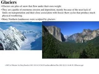
Glaciers
Glaciers. Nature’s Bulldozers CGF3M Wed. Nov. 6, 2013. Glacial Erosion . As glaciers move, they erode the land in two ways: plucking and abrasion.

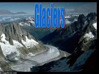
Glaciers
E N D
Presentation Transcript
Glaciers Nature’s Bulldozers CGF3M Wed. Nov. 6, 2013
Glacial Erosion As glaciers move, they erode the land in two ways: plucking and abrasion. • Plucking occurs when melt water penetrates the cracks and joints of bedrock beneath a glacier and then freezes. As the water freezes, it expands, prying pieces of bedrock loose. In this manner, sediment of all sizes become part of the glacier’s load. • Abrasion occurs when rock particles grind away the rock surface underneath, acting like a piece of sandpaper. Long scratches or grooves, called glacial striations, may be cut into the bedrock.
Glacial Erosion Different types of glaciers erode the landscape in very different ways: • Alpine Glaciers carve out and accentuate the rocky surfaces of a mountain landscape • Continental ice sheets override the terrain and smooth it out.
Factors that control the rate of erosion: • How quickly the glacier moves • How thick the ice is • The shape, number, and hardness of rock fragments at the base of the glacier • The type of surface beneath the glacier
Glacial Erosion The following slides outline features resulting from glacial erosion, and explains how they are formed.
U-Shaped Valley • Glaciers follow the path of least resistance by following the course of a pre-existing valley • A v-shaped valley is carved by the glacier into a U-Shaped valley. • The valley is now wider and deeper
Truncated Spur • As a glacier flows around sharp curves, it shears off pointed spurs of land that extend into the valley. • The result is a blunt-ended ridge of rock jutting from the side of a glacial valley.
Hanging Valley • A valley that drops steeply from high levels, feeding into a deeper main valley • Results in spectacular waterfalls • Created when a small tributary glacier joins a larger glacier
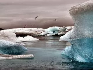
Fjord • A deep inlet where mountains meet the ocean • Flooded valley floors, were created when glaciers melted • May exceed depths of 1000 metres
Cirque • The point from which a glacier originally grew • Formed when the head of a glacier erodes backwards into the mountainside • Results in a hollowed out depression • Sometimes, a small lake, called a tarn, can be found at the bottom of the cirque.
Horn • An isolated spire of rock • Caused by a group of cirques around a single, high mountain • The Matterhorn in the Swiss Alps is the most famous example.
Arete • A narrow, knife-like feature • Caused by the growth of cirques on opposite sides of a ridge of rock • As the cirques grow, the ridge becomes more pronounced
Glacial Deposition • Large volumes of sediment are eventually deposited as the glacier melts • All sediments deposited by a glacier are called drift. • Drift may include sand, clay, or boulders • Materials deposited directly by the glacier are called till. • Sediments deposited by glacial melt water are called stratified drift. Often composed of sand and gravel.
Drumlin • An elongated or oval hill formed by ice sheets • Usually found in clusters • The steep side faces the direction from which the ice advanced • The gentler slope points in the direction of the movement of ice
Erratic • Common in NW Ontario! • A boulder found in the till or lying on the surface that differs from the underlying bedrock • Picked up by a glacier and may be carried far from its place of origin before the glacier deposits it
Esker • A long, narrow, meandering ridge of stratified drift • Formed when a meltwater river flows as a channel through old glacial ice and deposits sediments
Kames and Kettles • Kames are sediment hills- appear low and irregular • Kettles are depressions- formed when a block of ice becomes partially buried in drift and melts, leaving a pit in the sediment • Most kettles are less than 10m deep and no more than 2 km long • Kettles often fill with water and become ponds or small lakes
Moraine • An accumulation of boulders, stones, or other debris carried and deposited by a glacier • Terminal moraines are ridges of till that mark the former position of the end of the glacier • Recessional moraines form during the retreat of a glacier, whenever the ice stops for a while
Alluvial fana triangle shaped deposit of gravel, sand and smaller pieces of sediment such as silt. Created by flowing water. Associated with alpine glacier • Outwash plain A plain formed of glacier sediments deposited by meltwater at the terminus of the glacier. Associated with continental glacier.
In groups, define the following: Misfit stream A stream in a valley which is larger than would be predicted based on the stream’s erosive power Ribbon lakea long narrow lake found in a glacial trough. On area of alternating bands of hard and soft bedrock.
Scree Loose debris or talus accumulated at the foot of a cliff comprised of angular stones and boulders
Label the diagrams • Label the glacial features on LM 3-1a, using the terms we learned today.