Download
1 / 11
110 likes | 197 Vues
Explore how GIS technology is used in Danish education to analyze geospatial data, enhance learning, and foster cross-curricular collaboration. Discover various projects and tools like Eduspace and EduGIS contributing to advanced teaching methods and student engagement.

E N D
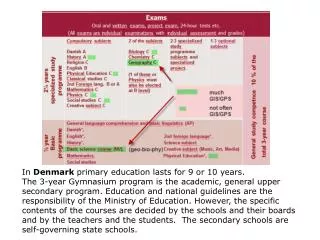
In Denmark primary education lasts for 9 or 10 years. The 3-year Gymnasium program is the academic, general upper secondary program. Education and national guidelines are the responsibility of the Ministry of Education. However, the specific contents of the courses are decided by the schools and their boards and by the teachers and the students. The secondary schools are self-governing state schools.
COURSE – Digital teachingmaterial from 1998 containingbasicreader, data and guidedexercises. The teacherusedthis website as a startingpoint. Scion Images couldmake “cloudmovies” of global wind. Data from the Joint Research Centre (JRC) in Italy
GOGIS.dk or gisgeo.dk.Software ArcViewto “build a bridge” between two “islands” consisting of the statistical, geo-related data and student-centered teaching methods. GIS is a good example of an IT tool which can be used to analyze and visualize huge quantities.The Informi GIS expertshelpeduswithcourses - in a very short time 35 % of all Geographyteachers in Denmark had participated.
Study trip to USA, Joseph Kerski, George Dailey, etc. in 2000 and 2003 – Remote Sensing and GIS
EduGIS has contributed material to Eduspace, which is a subdivision of ESA, creating learning and teaching tools for secondary schools, such as LeoWorks (digital image processing and GIS).
The Digital Atlas was implemented on a standard ArcIMS server with added extract and download facilities. The figure shows a local area around a gymnasium (high school) and shows that it is possible to download data.
Extract from a primary school GIS project on urban development at Klim, a small town in Denmark. Orthophotofrom COWI A/S, Statisticsfrom the StatBank Denmark and road net from KMS (National Survey and Cadastre)
Reform in 2005of upper secondary education in Denmark introduced a new basic science course including Biology, Chemistry, Geography and Physics in the Gymnasium. 1) “Radon”, including Biology, Geography and Physics2) ”Giant Hogweed”, mainly created by Biology3) ”Controversy”, constructed as a court case, where the arguments for the extinction of the dinosaurs have been drawn up rather sharply, and parts of it can be acted out as a kind of drama where the natural science arguments are pitted against each other. GIS is used in the analysis. 4) “The lake project”, an example of the development in the cultural landscape of a local area. 5) “Wind”, an analysis of the most environmentally friendly and energy-optimal location of windmills.
Statistics can be imported from spreadsheets and shown on maps like the ones shown here.Denmark is divided into municipalities, - here classified according to taxation base per inhabitant.
Silkeborg With GIS it is possible to find out who and howmanywillbelivingclose to the freeway. A buffer zone of 300 meters has beendesignatedalong the proposedfreeway
The future of GIS in schools • The successful introduction and use of GIS in education are dependent upon a standardized, easy access to quality data on the internet. This can be achieved through extensive collaboration between • data providers • schools and the Ministry of Education to ensure • attractive websites with data and manual • apps to smartphones and providers of program top laptop • teacher training. • A growing number of public services with GIS.The active citizen will gain a better insight into the decisionmaking processes behind changes in e.g. local development plans.It turns out that GIS is eminently suited to strengthen cross-curricular collaboration.