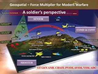
Harnessing Geospatial Data for Insight: From Collection to Analysis
This presentation explores the transformative power of geospatial data, emphasizing the importance of "when" and "where" in understanding various phenomena. It discusses historical case studies, such as Dr. John Snow's cholera investigation, and modern applications like Netflix queue visualization and monitoring North Dakota's oil boom. By leveraging metadata, interoperability standards, and crowd-sourced data, we can enhance our spatial data infrastructures (SDIs) for more efficient problem-solving and informed decision-making in diverse fields.


Harnessing Geospatial Data for Insight: From Collection to Analysis
E N D
Presentation Transcript
Insert Clever Title with Geospatialref here… Tommy Jasmin University of Wisconsin SSEC/CIMSS 18 Jul 2012
SSEC HawkCam http://metobs.ssec.wisc.edu/aoss/cameras/hawkcam-flash.html
Geospatial in my words • Add “when” and “where” to data • Find and retrieve that data • Visualize and analyze that data * Turning Earth-located data into useful information
Ok, but what’s “data”? • Almost anything, since we’re all walking GPSs, generating data • Firehose analogy 10x today
Even simpler… • “Everything is related to everything else, but near things are more related than distant things.” - Waldo Tobler
The First Geospatial Analysis Case London cholera epidemic, 1854, cause found by Dr. John Snow
Foreclosures Find less distressed and high-amenity neighborhoods to minimize cost
A peek into Netflix queues http://www.nytimes.com/interactive/2010/01/10/nyregion/20100110-netflix-map.html
And of course Remote Sensing NorthEast India as viewed by VIIRS, RGB generated by McIDAS-V
Suomi NPP Day/Night Band North Dakota oil boom – 30 April 2012
In Summary… • X-Over! MetaData, Interop, Doc, etc… • Everybody equal, Everybody participates, NO dumb questions • Let’s solve some problems together
A peek ahead #1, Morphing MetaData • From metadata doc to tagging • From catalog portals to search engines and social networks • From proprietary data to crowd-sourced
A peek ahead #2, Interoperability • As Geospatial data creation and distribution becomes easier across various technology and platforms, Interoperability increases dramatically in importance. • Interoperability standards like OGC become increasingly vital.
A peek ahead #3, SDIs A spatial data infrastructure (SDI) is a data infrastructure implementing a framework of geographic data, metadata, users, and tools that are interactively connected in order to use spatial data in an efficient and flexible way.


![[Insert exercise name]](https://cdn0.slideserve.com/1400721/insert-exercise-name-dt.jpg)