Download
1 / 28
280 likes | 479 Vues
APSDEU-6, Seoul, 1 June 2005. Status of Operational NWP System and the Satellite Data Utilization at JMA. Yoshiaki Takeuchi Numerical Prediction Division Japan Meteorological Agency. Contents. 1. Current NWP system at JMA 2. Recent developments 3. Future Plans. IBM 704.

E N D
APSDEU-6, Seoul, 1 June 2005 Status of Operational NWP System and the Satellite Data Utilization at JMA Yoshiaki Takeuchi Numerical Prediction Division Japan Meteorological Agency
Contents 1. Current NWP system at JMA 2. Recent developments 3. Future Plans
IBM 704 HITAC 5020F HITAC 8800 HITAC M200H HITAC S810K HITACHI S3800 HITACHI SR8000E1 1967.4 1973.8 1982.3 1987.12 1996.3 2001.3 1959.3 72.5 N-Hem. Balance Barotropic(381km) NH Balance(381kmL3) 70.4 75.1 NH Primitive;NHM(381km L4) NHM(381km L8) NH Spectral(T42L12) 83.3 Global Spectral; GSM(T63L16) 88.3 70.4 89.1 GSM(T106L21) Asia Quasi Geostrophic(304.8km L4) GSM(T213L30) 73.10 Asia Fine Mesh;FLM(152.4km L6) GSM(T213L40) GSM(TL319L40) FLM(127km L10) 05.2 83.3 FLM(127km L12) Regional Spectral ASM(75km L16) 88.3 RSM(20km L36) 83.3 Very Fine Mesh;VFM(63.5km L11) RSM(20km L40) VFM(63.5km L13) 84.1 88.3 JSM(40km L19) MSM(10km L40) Non-Hydrostatic MSM(10km L40) 92.3 JSM(30km L23) 04.9 History of the JMA NWP System
Global Model (GSM) Regional Model (RSM) Typhoon Model (TYM) Mesoscale Model (MSM) One-week Ensemble One-month Ensemble Objectives Medium-range forecast Short-range forecast Typhoon forecast Disaster reduction One week forecast One month forecast Forecast domain Global East Asia Typhoon and its surrounding Japan and its surrounding Global Grid size / Number of grids 0.5625 deg 640 x 320 (TL319) 20 km 325 x 257 24 km 271 x 271 10 km 361 x 289 1.125 deg 320 x 160 (T106) Vertical levels / Top 40 0.4 hPa 40 10 hPa 25 17.5 hPa 40 22,060m 40 0.4 hPa Forecast hours (Initial time) 90 hours (00 UTC) 216 hours (12 UTC) 51 hours (00,12 UTC) 84 hours (00,06,12, 18 UTC) 18 hours (00,06,12, 18 UTC) 9 days (12 UTC) 25 members 34 days (once a week) 26 members Analysis 4D-Var 4D-Var Interpolated from Global Analysis 4D-Var Global Analysis with ensemble perturbations Current NWP models of NPD/JMA
Domains of NWP models RSM (20km) GSM (60km) MSM (10km)
Supercomputer of JMAHITACHI SR 8000E1 (since March 2001) 80 nodes 768 Gflops (peak) Main memory: 640 GB Disk storage: 2.7 TB A mini-supercomputer, HITACHI SR8000F1 (8 nodes, 96 Gflops) was implemented in October 2003 for development of GSM.
Numerical Analysis and Prediction System System for Telecommunication Supercomputer (SR8000 E1/80) 768 GF、640 GB Operation Support System Disk (4.8TB) C-ADDESS DVD-RAM Library (2.4 TB) Networks FAX exchanging system Tape Library (80 TB) Operational Server KIYOSE Office (24km WNW from Tokyo) Meteorological Message Handling Server ATM 20Mbps Printers Operation Support System Operational Server Headquarters (Tokyo) DVD-RAM Library (3.1 TB) Networks Open I/O Room CMT DLT Printers WMO DDB Server 8mm/DAT Terminals for Forecast operational Office MT Printers Terminals for HQ Offices Terminals for Open I/O Room CD-R DVD-RAM
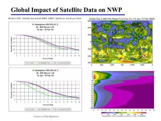
Performance of GSM (1) NH Z500 (Day 1) SH Z500 (Day 1) NH Z500 (Day 5) SH Z500 (Day 5)
Performance of GSM (2) WGNE Intercomparison of typhoon track forecasts from operational global models 72 hour forecasts
Contents 1. Current NWP system at JMA 2. Recent developments 3. Future Plans
Operational Changes to GSM in JFY2004 (1) ・A new parameterization scheme for marine stratocumulus (2004.7) ・A new long-wave radiation scheme and the parameterization of absorption in the short-wave radiation scheme (2004.12) Low level cloudiness New model Old model Sat. obs. Bias of downward radiative flux New model Old model
Operational Changes to GSM in JFY2004 (2) ・A semi-Lagrangian advection scheme, increase in the spectral resolution from T213 to TL319 (linear grid), an incremental non-linear normal mode initialization and a vertical mode initialization, etc. (2005.2) ・Assimilation of radio sonde temperature instead of the geopotential height (2004.4) ・A four-dimensional variational (4D-Var) data assimilation and revision of background error statistics (2005.2) Improvement of Typhoon track forecast Red: 4D-Var Blue: 3D-Var
Operational Changes to GSM in JFY2004 (3) ・Terra/MODIS and Aqua/MODIS winds in the north polar region (2004.5) and those in the south polar region (2004.9) ・Direct assimilation of ATOVS level 1C data instead of the level 1D data and the upgrade of the radiative transfer model from RTTOV-6 to RTTOV-7 (2004.12) ・Direct assimilation of Aqua/AMSU-A level 1C data (2005.3) Improvement of AC score of Z500 in NH Red: with MODIS Blue: w/o MODIS
Operational Change to MSM in JFY2004 (1) ・A non-hydrostatic mesoscale model (2004.9) Heavy rain in Bai-u season Hydrostatic MSM Radar/AMeDAS Non-hydrostatic MSM Snowfall in Winter
Operational Change to MSM in JFY2004 (2) ・Assimilation of QuikSCAT/SeaWinds (2004.7) ・Assimilation of Aqua/AMSR-E precipitation and precipitable water data (2004.11) ・Assimilation of Doppler Radar radial wind data (2005.3) Snowfall in Winter w/o SCAT Radar/AMeDAS with SCAT w/o AMSR-E with AMSR-E Radar/AMeDAS Heavy rain in Summer
Exchange of direct broadcast ATOVS data KMA (Seoul) OCT 2004 JMA provided KMA with sample data received at Kiyose processed by AAPP APR 2005 KMA provided JMA with sample data received at Seoul processed by AAPP 02 Jan 2005 Blue: KMA (Seoul) Level-1d Red: JMA (Kiyose) Level-1c CMA (Beijing, Guanzhou, Urumuqi, Lasha) Hong Kong China Needs to exchange of sample data BoM (Melbourne, Perth, Darwin, Casey)
Exchange of direct broadcast ATOVS data NOAA & SSM/I INTELSAT 1Mbps National Institute of Polar Research Direct Broadcast FEB 2004- HRPT or TIP (c) NIPR TBD JMA/MSC FEB 1997- AAPP L1C Proc. SEP 2004- Products (Map, Time sequence) TBD BoM etc. JMA/HQ GSM fcst 81MB/day Wave model fcst 2MB/day (GRIB 1.25deg) Assimilation & Forecast OCT 2004- RSMC server Syowa base AUG 2004- RV Shirase Dome Fuji
Scatterometer and microwave radiometer data From our recent experience of satellite data use, definitely a scatterometer much improves the operational NWP application as well as a microwave radiometer does. Furthermore the benefits are magnified synergically when the two instruments are aboard a satellite together. Continuation of QuikSCAT/SeaWinds and TRMM/TMI operations is essential in the operational NWP application. Early launch of METOP/ASCAT and GPMcore/GMI, and realization of GCOM-W/ AMSR-2 and SeaWinds are highly expected. Surface wind derived from QuikSCAT / SeaWinds and precipitable water (colored circle dots) and rain rate (colored square dots) derived from SSM/I and TMI. All data for 06UTC-12UTC 27 August 2004 are usedin the JMA meso-scale NWP model.
Contents 1. Current NWP system at JMA 2. Recent developments 3. Future Plans
Development Plans for JFY2005 New Observation • MWR (SSMI / TMI / AMSR-E) radiance data for GSM • 0.25 deg. SST data based on AVHRR and MWR for GSM, RSM and MSM • Revised bias correction of ATOVS 1C data for GSM • MTSAT-1RAMV and Meteosat-8 AMV for all models • MTSAT-1Rhourly AMV for all models • Geostationary satellites WV data for GSM based on RTTOV-7 • Aqua/AIRS radiance data for GSM • GPS occultation data for GSM Analysis and Model • Improvement of resolution of 4D-Var inner model for GSM • Modification of physics for GSM (cloud radiation, gravity wave drag, etc.) • Two time level integration and a reduced grid for GSM • 8times operation of5kmMSM a day
New Supercomputer of JMA NWP Satellite data processing • Hitachi SR11000J1 • 2.1GFlops×16processors×80nodes×2=21.5TFlops • 1.9GFlops×16processors×50nodes×1=6.1TFlops • 13.1TB Main memory • 67TB Disk • 2PB Tape Mar 2005- Mar 2006- 80nodes 50nodes 80nodes HITACHI SR11000J1 -210nodes 27.5Tflops
Plan of the JMA NWP System JFY 2002 2003 2004 2005 2006 2007 2008 2009 2010 2011 2012 2013 Thick arrows: forecast models Thin arrows : assimilation methods Seasonal Ensemble Weekly Ensemble T106L40M25 TL159M51 CGCM TL159L60M51+0.5deg 120km TL159L60M51 TL319L60M51 BGM→SV GSM T213L40 TL319L40 60km 3D-Var 4D-Var TL319L60M11 Typhoon Ensemble TL479L80M51 40km TYM 24kmL25 TL479L80M25 Horizontal resolution RSM with mixed layer TL959L60 TL959L80 20kmL40 20km OI 4D-Var with EKF 4D-Var 4D-Var Meso- Ensemble MSM Non-hydrostatic 10kmL40 10km Hydrostatic Hydrostatic 4D-Var 5kmL50 5kmL60 5km Non-hydrostatic 4D-Var 2kmL60 High-res. MSM 2km Non-hydrostatic3D-Var Computer Replacement Computer Replacement
Requirements from JMA • Continuation of the QuikSCAT and TRMM operation (NASA) • SeaWinds for GCOM-W and GMI for GPM (NASA) • SSM/IS distribution through GTS (NWS, NESDIS) • ASCAT distribution through GTS (NWS, NESDIS, EUMETSAT) • DB ATOVS data through GTS (CMA, KMA, BoM, EUMETSAT, …) • CSR data of GOES through GTS (NWS, NESDIS) • Image data of GOES and METEOSAT8 through GTS (NWS, NESDIS, BoM, EUMETSAT)