Download
1 / 52
540 likes | 852 Vues
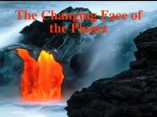
The Changing Face of the Planet. Earth’s Interior. Information gathered about the interior comes from complex instruments and earthquakes Earthquakes produce shock waves that travel through the Earth

E N D
Earth’s Interior Information gathered about the interior comes from complex instruments and earthquakes • Earthquakes produce shock waves that travel through the Earth • Changes occur in the movement of these seismic waves due to differences in the structure and makeup of the Earth’s interior • Scientist have determined what the interior looks like by monitoring the path and speed of seismic waves
The Earth’s Core • The Earth’s core is subdivided into two layers, an inner and an outer core • Both layers of the Earth’s core are composed of the elements iron and nickel
The Inner Core Inner Core-The solid, innermost layer of the Earth • Temperatures reach 5000° C • Radius is about 1300 Km • Intense pressure causes the particles of iron and nickel to remain solid • The presence of a solid iron in the core may explain the existence of magnetic fields around the Earth
The Outer Core Outer Core-Layer of the Earth surrounding the inner core • Temperatures range from 2200°C to 5000°C • About 2250 Km thick • High temperatures keep the iron and nickel in the outer core molten
The Earth’s Mantle • Mantle- The layer of Earth directly above the outer core • Extends to a depth of about 2900 Km below the surface • Contains about 80% of the volume of the Earth and 68% of its mass • Made mostly of the elements silicon, oxygen, iron, and magnesium • Density increases with depth • Temperatures range from 870°C to 2200°C • Rock in the mantle can flow like a thick liquid (Has plasticity)
The Earth’s Crust • The crust is the Earth’s outermost layer • Made up of three types of solid rock • Thickness of the crust varies with type • Oceanic crust (makes up the ocean floor) is less than 10 Km thick • Continental crust (makes up the landmasses) has an average thickness of about 32 Km
Other Divisions of the Earth’s Interior • Mohorovicic discontinuity (Moho)-Boundary separating the crust from the mantle • Lithosphere- • Topmost solid part of the Earth • Composed of the crust and part of the upper mantle • Broken into large sections called plates • Asthenosphere- • Layer of Earth directly beneath the lithosphere • Located near the upper edge of the mantle • A hot weak zone, capable of gradual flow
The Earth’s Changing Interior • It is believed that the Earth was not originally layered, the divisions we see today formed slowly over time • Shortly after the Earth was formed, the decay of radioactive elements, along with heat released by colliding particles, produced melting in the planet’s interior • Melting allowed the heavier elements (iron & nickel) to sink toward the center, while lighter, rocky components floated upward • Still occurs today on a smaller scale
Plate Tectonics • Theory which links the concepts of Continental Drift and Sea-floor Spreading to explain how the Earth has evolved over time • Helps to explain the formation, movements, collisions, and destruction of Earth’s outer layers • Helps people understand the geologic past and predict its future
Evidence for Plate Tectonics • Continental Drift • Volcano and Earthquake Belts • Sea-floor Spreading • Paleomagnetism
Continental Drift • Proposed in 1912 by Alfred Wegner • States that the continents were once joined together as a super-continent called Pangaea and have since drifted apart
Evidence for Continental Drift • Shape of the continents • Similar fossil deposits on continents thought to have been joined • Rock formations that end at the edges of continents • Glacial deposits • Distinctive rock types
Location of the world’s volcano & earthquake belts • Lie along plate boundaries (places where one plate moves relative to another) • Caused by stresses that build up along the boundaries • As stresses become too great, fractures form and earthquakes occur • Fractures allow magma from the asthenosphere to reach the surface, forming volcanoes • Most of the world’s volcanoes are located along the outer edge of the Pacific Plate (the ‘Ring of Fire’)
Sea-floor Spreading • Sea-floor spreading- Process in which old ocean floor is pushed away from a mid-ocean ridge by the formation of new ocean floor • Occurs at divergent boundaries (also called spreading centers) • Younger rocks are found closer to the spreading center • The further you go from the spreading center, the older the rocks become • The same pattern of rocks are found on both sides of the center
Paleomagnetism • Paleomagnetism- Study of the alignment of magnetic particles in ancient rocks • Provides proof for sea-floor spreading and a means of determining how the continents have moved • When magma cools, grains of iron line up with the magnetic pole (like little compasses) • Polarity reversals occur in parallel bands on opposite sides of the mid-ocean ridges • During the past 4 million years, the magnetic poles have reversed themselves 9 times
Theory of Plate Tectonics • States that the topmost solid part of the Earth is divided into rigid plates that move resulting in earthquakes, volcanoes, mountains, and the redistribution of landmasses • Lithospheric plates are made of a thin layer of crust above a thick layer of rigid mantle rock • Usually contain both oceanic and continental crust • Seven major plates, each named after its surface features • Plates move at different speeds and in different directions
Plate Boundaries There are three basic types of plate boundaries • Divergent- moving apart • Convergent- moving together • Transform fault- sliding past each other
Divergent Boundaries • Plates move apart (diverge) • Also called spreading centers or constructive boundaries • New rocks are formed as older rocks are pushed aside (Lithosphere is created) • Examples: Mid-Atlantic Ridge, East Pacific Rise, and the Great Rift Valley in Africa
Convergent Boundaries • Occur where two plates move towards each other • Also called destructive boundaries • Lithosphere is destroyed • There are three types
Types of Convergent Boundaries Convergent boundary where two continental plates collide • Forms a single larger continent (India & Asia) • Causes the lithosphere at the boundary to be pushed up, forming a mountain range • Ex.: Himalayas, Urals, & Appalachian Mtns.
Types of Convergent Boundaries Convergent boundary where two oceanic plates collide • One plate subducts (goes under) the other plate • Also called a subduction zone • Forms a chain of volcanic islands on the overriding plate and a deep sea trench • Ex.: The Mariana Islands and the Mariana Trench are formed where the Pacific Plate subducts under the Philippine Plate
Types of Convergent Boundaries Convergent boundary where an oceanic and a continental plate collides • The oceanic plate subducts under the continental plate • Forms a chain of volcanic mountains on the continental plate and a deep sea trench • Ex.: Along the west coast of South America, the Nazca Plate subducts under the South American Plate, forming the Andes Mtns. And the Peru-Chile Trench
Transform Fault Boundaries • Also known as strike-slip or sliding boundaries • Plates grind together as they try to slip past each other horizontally causing stress to build up • Earthquakes occur when the stress is released • Examples: • The San Andreas Fault in California, is a result of the North American Plate and the Pacific Plate trying to slide past each other • Transform fault boundaries connect portions of the mid-ocean ridge system that are moving at different rates
Why the Plates Move • Convection currents within the asthenosphere are thought to be the driving force behind plate movement • Convection current- the movement of material caused by differences in temperature • Hot magma rises to the surface, pushing the older rocks aside and driving the plates apart (occurs at divergent boundaries) • Cooler, denser currents sink back into the mantle, pushing the plates together (occurs at convergent boundaries)
Earthquakes • Earthquakes- Shaking and trembling that results from the sudden movement of part of the Earth’s crust • The most common cause is faulting • When part of the crust is pushed together or pulled apart • Occur when the stress along a fault overcomes the force of friction and releases stored energy • Can also be triggered by volcanic eruptions, collapse of caverns, and meteor impacts
Where Earthquakes Occur • Most earthquakes occur at plate boundaries • Focus- Point beneath the Earth’s surface where the rock breaks and moves • Depth of the focus depends on where it occurs • Earthquakes at divergent boundaries are shallower than those that occur at subduction zones • Epicenter- Point on the Earth’s surface directly above the focus
Seismic Waves Seismic waves- Shock waves produced by earthquakes ( 3 types) • Primary Waves (P Waves) • Secondary Waves (S Waves) • Surface Waves (L Waves)
Primary Waves Primary waves (P waves)- Push–pull seismic waves that can travel through solids, liquids, & gasses • Travels from the focus by compressing and expanding the material it passes through • Fastest of the earthquake waves
Secondary Waves • Secondary waves (S waves)- Side-to-side moving earthquake waves which can travel through solids but not liquids or gasses • Rock particles move at right angles to the direction of the wave • Travels through the interior from the focus • Slower than P waves, but faster than L waves
Surface Waves Surface waves (L waves)- Up-and-down earthquake waves • Move along the Earth’s surface like waves travel in the ocean • Originate at the epicenter • Bend and twist the Earth’s surface, causing most of the damage during an earthquake
Locating Earthquakes • Seismographs- (Instruments used to detect and measure seismic waves) are used to locate earthquakes • Data about each type of seismic wave is taken from the seismograph and plotted on a time-travel graph • The epicenter is located by taking the distances from three different reporting stations and finding the point where they intersect (also called triangulation) • The depth of the focus is determined by measuring the lag time of the L waves
Measuring an Earthquake • Seismographs are used to measure the strength, or magnitude, of an earthquake • Magnitude is determined by measuring the amplitude (height) of the largest wave recorded by a seismograph • The Richter Scale measures the strength of an earthquake • The Mercalli Intensity Scale measures the damage done to various structures by an earthquake
The Richter Scale • Used to describe the magnitude or strength of an earthquake • Measures the amount of energy released • Each number on the scale indicates an earthquake that is ten times stronger than the next lower number • A magnitude 5.0 earthquake is ten times stronger than a 4.0 quake • Major earthquakes have magnitudes of 7.0 or higher
The Mercalli Intensity Scale • Measures the intensity of an earthquake • Measures the damage done to different types of structures • Identifies what someone might experience (see, hear, or feel) during the earthquake • Scale ranges from I to XII, where I is hardly felt and XII indicates total destruction
Earthquake Damage • The amount of damage mostly depends on the earthquake’s magnitude and its proximity to populated areas • Other factors that determine the amount of destruction include: • Duration of the quake • Time at which the earthquake occurs • Types of buildings • Material on which structures are built • Fire caused by broken gas mains • Broken waterlines hampering firefighters • Tsunamis along coastal areas
Volcanoes • Volcano-Place in the Earth’s surface through which molten rock and other materials reach the surface • Parts of a volcano • Crater- Depression at the summit of a volcanic cone • Magma chamber- Large reservoir of magma below the Earth’s crust • Vent- Opening from which volcanic material is ejected
Volcanism Releases Magma • Magma- Melted rock below Earth’s surface • Magma forms where temperatures are high enough to melt rock • Asthenosphere • Plate boundaries • Magma rises to the surface because it is less dense than the surrounding material • The rate at which magma flows is determined primarily by its silica content
Felsic Magma Also called granitic magma High silica content Viscous or thick Slow moving Contains a lot of water Creates explosive volcanic eruptions Mafic Magma Also called basaltic magma Low silica content Less viscous or thin Flows easily Contains very little water Produces quiet volcanic eruptions Two Types of Magma
Gases in Magma • Magma contains dissolved gases that are released during an eruption • Gases are primarily water vapor, carbon dioxide, and sulfur • Magmas containing higher amounts of dissolved gases produce more explosive eruptions than those with smaller amounts
Temperature of Magma • Magma ranges in temperature from about 1000°C to 1200°C • The hotter the magma, the easier it flows • Hotter magmas trap less gas • Hotter magmas are associated with quieter eruptions
Lava • Lava- Magma that reaches the surface • Two types: • AA • Pahoehoe • How lava differs from magma • Composition is slightly different • Some gases have escaped • New material is often added when the magma comes in contact with other rock • Temperature is lower
Volcanic Eruptions • Three factors determine the nature of a volcanic eruption • Composition of the magma • Temperature of the magma • Amount of dissolved gases • Different types of eruptions form different types of volcanoes
Three Main Types of Volcanoes • Shield Volcanoes • Cinder Cones • Composite Volcanoes
Shield Volcanoes • Large, gently sloping dome-shaped volcanic mountains • Made from fluid, basaltic lava (mafic magma) • Produced by quiet eruptions • Formed at “hot spots” • Example: Mauna Loa (Hawaiian volcano)
Cinder Cones • Small, steep-sided volcanoes • Produced by violent, pyroclastic ejections of material from a central vent • Made of cinders and other rock particles (felsic magma) • Usually occur in groups • Found along convergent boundaries • Example: Paricutin, Mexico
Composite Volcanoes • Large, steep-sided, cone-shaped volcanic mountains • Built of alternating layers of rock particles (pyroclastic material)and fluid lava • Produced by very violent eruptions • Found along convergent boundaries • Example: Mt. St. Helens
Where Volcanic Activity Occurs • Divergent boundaries- produces rift zone eruptions • Convergent boundary- creates subduction zone eruptions • At hot spots, in the middle of lithospheric plates- produces hot spot eruptions
Rift Eruptions • Occur along narrow fractures in the crust (usually along divergent boundaries) • Mid-Atlantic Ridge • East African Ridge • Magma wells up to fill the gap as the crust splits • Eruptions are typically quiet • Magma is basaltic • Magma contains little gas