Download
1 / 25
250 likes | 384 Vues
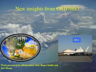
New insights from GRIP/HS3. HS3. Work presented in collaboration with: Roger Smith, Jun Zhang and Mark Boothe. Overarching NASA-HS3 Science Questions :. How do hurricanes form? What causes rapid intensity change? What is the role of deep convection in intensification?

E N D
New insights from GRIP/HS3 HS3 Work presented in collaboration with: Roger Smith, Jun Zhang and Mark Boothe
Overarching NASA-HS3 Science Questions: How do hurricanes form? What causes rapid intensity change? What is the role of deep convection in intensification? What is the role of Saharan Air Layer (SAL) on intensity change? 1. S. Braun and R. Kakar
Highlights of our work relevant to addressing the first three questions Thermodynamic environment of developing and non-developing disturbances during PREDICT and GRIP (Smith and Montgomery 2012, QJRMS) How important is the isothermal expansion effect in elevating theta_e in the hurricane inner-core? (Smith and Montgomery 2013, QJRMS) ** Analysis of dynamical and thermodynamical structure during the evolution of Earl (2010) (Montgomery, Zhang and Smith 2013, QJRMS, in review) ** Developed new model of secondary eyewall formation that can be tested with HS3 data (Abarca and Montgomery 2013, JAS, in press; see posters) Obtained new insight on the dynamics and predictability of the tropical cyclogenesis of Hurricane Sandy (2013). These findings can be applied to other Atlantic and Caribbean tropical disturbances (Lussier, Rutherford, Montgomery, Dunkerton and Boothe, 2013; see poster) Developing new insight into processes supporting the longevity of Tropical storm/Hurricane Nadie (Rutherford, Dunkerton and Montgomery; see poster)
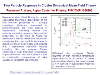
Revised view of intensification: two mechanisms Absolute angular momentum 15 10 z km 5 M conserved 0 50 r km 100 Mreduced by friction, but strong convergence small r (for details, see review paper by Montgomery and Smith (2013 AMOJ)
Lower fuselage radar coverage straddling periods 1 & 2 (22 Z 28 Aug – 12 Z 30 Aug; rapid spin up)
dropsonde data spatial coverage during four 12 h analysis periods (1-4)durin Blue, P-3 Red, DC-8 Green, C-130 Black, G-IV
Gradient wind Vg at height of max Vt for periods 1 and 2 (Aug. 28 and 29)
Gradient wind at height of max Vt for periods 3 and 4 (Sept. 1 and 2)
Lessons learned Re low-level intensification of Earl (2010) • Maximum mean Vt is within the frictional boundary layer during the spin up phase • Supergradient mean Vt was found in the eyewall region at the height of maximum Vt during both spin up and maturity • These findings support in part the new intensification paradigm in which HBL plays an active role in dynamics
New dynamical and thermodynamical insights from GRIP/HS3 • Revised intensification model helps synthesize multi-scale observations • and predicts new aspects of the intensification process. Observational data and • analyses support the revised model, which predicts the maximum tangential • velocity occurs persistently within the frictional BL and predicts the significant • the generation of supergradient winds within but near the top of the BL. • 2. In the azimuthally-averaged view, the revised model comprises the cooperative • intensification mechanism (Ooyama) + BL spin up mechanism in conjunction • with moderately enhanced surface moisture fluxes to maintain convective • instability in the developing core of the storm. • 3. Observations suggest that radial inflow is maximum near the surface, and • consistent with that of Bodewat boundary layer flow (Schlichting 1968, Ch. 11). • [Is `Log layer’ universal? No!] • (This work is complementary to that of Neil Sanger et al. 2013 (MWR, accepted with minor • revision).)
In press Available at: http://www.meteo.physik.uni-muenchen.de\~roger\Pubs/M12A.pdf
v e v e
put Dqe1 Dqe2 Dqe3