Download
1 / 51
520 likes | 904 Vues
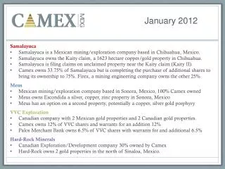
January 2012. Samalayuca Samalayuca is a Mexican mining/exploration company based in Chihuahua, Mexico. Samalayuca owns the Kaity claim, a 1623 hectare copper/gold property in Chihuahua. Samalayuca is filing claims on unclaimed property near the Kaity claim ( Kaity II).

E N D
January 2012 Samalayuca • Samalayuca is a Mexican mining/exploration company based in Chihuahua, Mexico. • Samalayuca owns the Kaity claim, a 1623 hectare copper/gold property in Chihuahua. • Samalayuca is filing claims on unclaimed property near the Kaity claim (Kaity II). • Camex owns 33.75% of Samalayuca but is completing the purchase of additional shares to bring its ownership to 75%.Firex, amining engineering company owns the other 25% Meus • Mexican mining/exploration company based in Sonora, Mexico, 100% Camex owned • Meus owns Escondida a silver, copper, zinc property in Sonora, Mexico • Meus has an option on a second property, potentially a copper, silver gold porphyry VVC Exploration • Canadian company with 2 Mexican gold properties and 2 Canadian gold properties. • Camex owns 12% of VVC shares and warrants for an addition 12% • Palos Merchant Bank owns 6.5% of VVC shares with warrants for and additional 6.5% Hard-Rock Minerals • Canadian Exploration/Development company 30% owned by Camex • Hard-Rock owns 2 gold properties in the north of Sinaloa, Mexico.
Camex Mexican Properties Samalayuca Cerro Blanco Cumeral La Escondida La Tuna Copper Creek
Samalayuca Project(Kaity Claim) • Located 60 K South and West of El Paso Texas in Chihuahua Mexico • Stratiform sedimentary copper deposit with significant gold and silver in at least 5 mineralization zones • 43-101 with speculative inferred resource of 38 million pounds of copper on approximately 10% of the area and to a depth of only 40 meters • Pursing unclaimed property adjacent to Kaity with indications of mineralization continuation from Kaity • State of Chihuahua agreed to provide and pay for electricity to the property • Land use contracts in place with all land owners (ejidos) for Pilot Mine • Firex—a Mexican Mining Engineering and Contracting firm and 25% owner of Samalayuca will provide all of the capital for the startup of the Pilot Mine
Google Map View of Samalayuca Claim 10K by 3K on 1623 Hectares
SamalayucaPosition Production Feasibility Proven Reserves Pre-feasibility Drilling Resource Evaluation Pilot Mine Definition Drilling First Resource Calculation Exploration/Drilling Stage Project Acquisition/Surface Evaluation
Samalayuca Five Principal Mineralized Zones
Exploration January 2010: Reconnaissance sampling in all historically mined zones in Samalayuca claims by André St-Michel April 2010: Detailed sampling in principal historical mined zones, including Gloria, Gloria Extention, Concha, Juliana, Zorra, Trinidad, and Suerte by Edwardo P.C., Bsc.Geology January 2011: Regional mapping and sampling around Gloria, Gloria Extention, Concha, Juliana, Zorra zones by Jocelyn Pelletier, P Geo April 2011: Detail mapping and sampling in Concha zone by Jocelyn Pelletier, Pgeo. Visit and review by Julio Pintado, PhD, P.Geo, Mexican specialist. May 2011: Detail mapping and sampling in Gloria and Gloria Extention zones by Jocelyn Pelletier, Pgeo. Visit and review of project Michel Gauthier, PhD, P.Geo, metallergy and stratiform copper deposit specialist. October 2011: 43-101 completed covering 10% of project to depth of 40 meters—inferred copper resource of 38 million pounds. Samalayuca 1950’s-1970’s: Artisanal mining-ore to Asarco 1965:Minera Fresnillo:5 drill holes--854m 1967: Pemex: Detail mapping activities. 1969:MS Thesis of Edgar L. Berg for UT Austin: Geological studies and mapping 1970: Earth Resources: 2 drill holes 1992-1993: MXUS:Mapping, sampling, drilling-51 air track, 4 reverse circulation, and 2 core drill holes 1993: MS Thesis Craig Bruno,QueensCollege, New York: Exploration, geological studies and mapping activities 1997-98:Phelps Dodge: Mapping, sampling, drilling. AbandonedafterPhelps Dodgesale in 98
SamalayucaCopper Mineralisation Model • 3 Principal Types of Possible Mineralisation
SamalayucaCopper Mineralisation Three Types of Mineralization in Samalayuca Model • Original diageneticstratiform copper mineralisation • Lateral zonation of copper mineralisation • Copper content ranges from 0.25% to 1% • Secondary structural enrichment • Results from stratification • Quartz vein remobilisation. • Copper content ranges from 1% to 2% • Supergene Enrichment • Surface lixiviation • Enrichment along vertical fractures in oxididation zone. • Enriched sulfides in zone. • Copper content is 2% and higher
Samalayuca Typical Stratiform Mineralisation Typical mineralisation of chloritisedquartzitic-arenite beds (20-100cm) with low grade mineralisation, with rarely observable copper sulfides dissemination. Malachite-chrysocola fractures with up to 1-2% Cu.
Supergene(black zone) • Enrichment is late geological phenomenon due to meteoritisation, where the original mineralisationis transfomed and remobilised lower in the host rock. • Meteoric waters intrude along porosity and structural weak planes to attack original minerals, such as sulfides to transformed them into secondary minerals, such as hydroxydes-oxydes-carbonates). • Secondary minerals are remobilised and concentrate along fault and fracture zone. • Possibility of copper enrichment by circulation of copper ion (Cu++) absorbed by sulfides all along the descent. • Geochemical change is more intense in reduced oxidation conditions. • Supergene copper content over 2% SamalayucaSupergene Enrichment
Samalayuca Supergene Copper Enrichment Interpretation Cu+ Malachite Malachite CopperSulfides Chrysocolla Brochantite Chalcocite, Digenite Tenorite, Cuprite Bornite, Covellite Chalcopyrite Pyrite
Exampleof High-Grade Supergene Copper Ore Chuquicamata (Chile)
Recommendations for Samalayuca Property • Complete permittingprocess • Drill area chosen for heapleach pads to insureagainstcoveringmineralization zone • Start Pilot Mine • Complete the resourceevaluation of the balance of the Kaity claim and if appropriateKaity II
Meus • 100% Camex Owned Mexican Company • Escondida • Located in Northern Sonora State of Mexico • 70 K from Arizona border, 140 K from Tuscon • Contains significant silver with gold, copper and lead • Surface samples contained more than 100 ounces of silver per ton • 43-101 in progress—expected by end Q1 of 2012 • Cerro Blanco • 50 K from La Escondida is under option • A gold, silver, copper project with a breccia pipe that strongly suggests a large porphyry deposit at depth
Camex Mexican Properties Samalayuca Cerro Blanco Cumeral La Escondida La Tuna Copper Creek
Escondida • Escondida project is located in Central Sonora, Mexico, 140 K south of Tucson Arizona. • Property covers 178 hectares with three major mineralization structures. • Initial exploration campaign was begun in July 2011, with 116 samples taken as the mapping of the property was completed. • The property show very interesting high grade values of silver, and considerable values of gold—12 samples had more than 300 grams of silver per ton and 7 had over 0.5 grams of gold per ton. • An initial 43-101 is in progress with expected completion in Q1 of 2012.
Escondida Position on the Camex Triangle Production Feasibility Proven Reserves Pre-feasibility Drilling Resource Evaluation Pilot Mine Definition Drilling First Resource Calculation Exploration/Drilling Stage Project Acquisition/Surface Evaluation
Historical Exploration & Mining Work Escondida • Copper discovered in region in 1660 • Carlin type deposits in area mined including gold at Santa Gertrudis and gold/silver at Las Chispas • Known gold/silver quartz mineralizations close to Escondida include: • Guijas—200 m north • Renegada—6.4 km SSW • San Vicente—11.6 km SSW • Las Flores—16.5 km SW • La Soledad—14.7 km NW • El Otate—17.6 km NNW • Merceded—24 km NE • Unknown Substantial artisanal mining of gold and silver evidenced by small pits, mine dumps and stockpiles • 2009: Mexican Company Prospection and channel chip sampling (170 samples) with values up 1.85 g/t Au over 1.2 meters wide • 2011:Meus 116 rock chips, block and grab samples with values reaching: 300 oz per ton silver 3.99 grams per ton gold
January 2011: Reconnaissance sampling in all historically mined zones in Escondida claims by André St-Michel October 2011: Regional mapping and sampling by Jocelyn Pelletier, P Geo Novermber 2011: Visit and review of project by JaquesMarchand for initial 43-101study November 2011: Visit and review of project Michel Gauthier, PhD, P.Geo, metallergy and stratiform copper deposit specialist. December 2011: First Draft of 43-101 completed covering. EscondidaExploration Activities
Escondida EpizonalAu-Ag-Sb Deposit Jamesonite (Pb4FeSb6S14)--Lead mineralizationatEscondida indicatescharacteristic Au-Sb epizonalorogenicmetallic association
Second type of mineralizationtarget in Escondida:Gold-bearing quartz veinletsstockwork in competent gabbro Escondida
Kalgoorlie(Australia):A world-class orogenic gold deposit in suchcompetent gabbro
Recommendations for Escondida Property • First completea groundmagneticsurvey to delineate the gabbro competent mass within the incompetentturbiditesequence • Engage a geophysicist to carry out a 3D mag inversion thatcanbeintegrated in a 3D GIS software • Plan a couple of diamond drill holesthatwouldtarget: 1) pressure shadow zone in the gabbro mass and 2) probe a possible saddlereefstakingbelow La Generosa, La Abundancia and La Discreta ‘veins’ • Thesethreestepscanbecompletedrelativelyquickly and cheaply to determine if Escondida isindeed a large depositor simply gold silverveinlets.
Cerro Blanco • Sonora, Mexico, 45 K from Cananea • The property is 297 hectares characterized by Au-Ag enargite veins with great potential for gold silver and copper. Historically there has been considerable exploitation of high grade veins. • These mineralized veins are on top of a pebble breccia pipe suggesting a porphyry copper target that is a possibility for open pit exploitation. • Initial sampling shows relatively high grade values for gold silver, and copper (5.45 g/tn Au, 0.7kg/tn Ag and 1% copper • Project has similar characteristics to Butte (Montana), “the richest hill on earth.”
Cerro Blanco Position on the Camex Triangle Production Production Feasibility Proven Reserves Feasibility Proven Reserves Pre-feasibility Drilling Resource Evaluation Pilot Mine Pre-feasibility Drilling Resource Evaluation Pilot Mine Definition Drilling First Resource Calculation Definition Drilling First Resource Calculation Exploration/Drilling Stage Exploration/Drilling Stage Project Acquisition/Surface Evaluation Project Acquisition/Surface Evaluation
Classic Model forAu-Ag EnargiteVein-System on Top of a PorphyryCopper Target
SignificantPresence of Breccia-Pipe atCerroBlanco Similar to Classic Model
Cerro Blanco has similarcharacteristics to nearbyCananea
Recommendations for Cerro Blanco • Complete a groundInducedPolarization (IP) survey of the property. • If IP anomalies are detected, especiallybelow the en échelon veins system make a 3D IP inversion thatcanbeintegrated in a 3D GIS software for evaluation and exploration planning • Based on the 3D GIS evauuation drill one or twodeepdiamond drill holes to probe IP anomalythatwouldbecoincident to an outcropping Cu-Au vein system.
VVC Exploration • Public Company • Camex owns 12% of VVC shares plus warrants equivalent to another 12% of VVC shares • Palos Merchant Bank owns 6.5% of VVC shares plus warrants equivalent to another 6.5% of VVC shares • VVC has four projects • Cumeral in Northern Sonora, Mexico • La Tuna in Northern Sinaloa, Mexico • Timmons Township project Ontario, Canada • Beauce-Bellechasse Gold Property in Quebec, Canada
Camex Mexican Properties Samalayuca Cerro Blanco Cumeral La Escondida La Tuna Copper Creek
Cumeral • Property covers 6,649 hectares in the State of Sonora, Mexico—140K from Tucson Arizona. • Located on the Sierra Madre Occidental in the Sonora Desert at approximately 900 meters elevation. • Surface sampling and air track drilling in four zones show the presence of Gold, Silver and Copper. • Based on the mineralization the property has the potential for significant deposits of gold.
Cumeral An epithermal gold deposit in an extensionaltectonicsetting
Cumeral Position on the Camex Triangle Production Production Feasibility Proven Reserves Feasibility Proven Reserves Pre-feasibility Drilling Resource Evaluation Pilot Mine Pre-feasibility Drilling Resource Evaluation Pilot Mine Definition Drilling First Resource Calculation Definition Drilling First Resource Calculation Exploration/Drilling Stage Exploration/Drilling Stage Project Acquisition/Surface Evaluation Project Acquisition/Surface Evaluation
(FromGroves, D.I., Goldfarb, R.J., Gebre-Mariam, H., Hagemann, S.G., and Robert, F., 1998. Orogenic gold deposits- A proposed classification in the context of theircrustal distribution and relationship to other gold deposit type: Ore geologyReviews, v. 13, 7-27).
Mesquite gold mine 8 MOz Au reserves+resources Amongcurrentbiggest US gold mine Cumeral Location Relative to Properties that are Possible Comparables La Herradura mine 2.3 MOz Au reserves Mexico biggest gold mine (Newmont-Penoles 2010) Cumeralproperty San Francisco mine 1 MOz Au resourcesNov 2011 43-101
Cumeral Location and Mineralization Model Relative to Existing Mines Detachmentfault Metamorphic rock Cumeral Lluvia de Oro mine San Francisco mine
Recommendations for Cumeral Property • Complete a campaign of vertical shallow, diamond drill holes (ddh) to delineatean expected, flat, near surface, bulk-tonnage gold deposit. • A first NW-SE line of ddhshouldbestartedjustabove the Cascabelpit and progresssoutheastwardwith 100m increments. • If this first line of ddhissuccesful in delineating a near surface flat gold zone, ddhfencedrillingshouldprogressnorthward and southward
La Tuna • Property covers 3,533 hectares in the State of Sinaloa, Mexico • Located in the Alamos Municipality • Three Ore Bodies exist in the La Tuna Claim • A gold vein that could be mined by open pit method • Baboyahui Gold Placer • Porphyry Copper ore body not yet explored • Surface sampling and grab samples in the Baboyahui structure operated in the 1940’s show results as high as 16.23 gram gold per ton of ore. • The mineralization of the property and limited vein sampling by a Australian company during the period of 1987 to 1991 suggest the potential for deposits of as much as 500,000 ounces of Gold and an undetermined amount of Copper.
La Tuna Position on the Camex Triangle Production Production Feasibility Proven Reserves Feasibility Proven Reserves Pre-feasibility Drilling Resource Evaluation Pilot Mine Pre-feasibility Drilling Resource Evaluation Pilot Mine Definition Drilling First Resource Calculation Definition Drilling First Resource Calculation Exploration/Drilling Stage Exploration/Drilling Stage Project Acquisition/Surface Evaluation Project Acquisition/Surface Evaluation
Timmons Township • Property located 48 K east-southeast of the City of Timmons. • Prime target for base metals exploration • Strong airborne electromagnetic responses with a complex magnetic system • Property covers a northwest trending zone of strong airborne electromagnetic responses. • Initial program comprising line cutting and detailed geophysical surveys was carried out in 2008. • Encouraging drilling targets have been identified. • Follow up work deferred as resources are concentrated in Mexico
Beauce-Bellechasse • Property consists of 250 claims on 13,500 hectares in the Beauce area of Quebec, 70 km SE of Quebec City • Prime target for gold exploration • Area is known for its chromite and copper deposits and gold placers • Follow up work deferred as resources are concentrated in Mexico
Hard-Rock Minerals • Hard-Rock Mineral Developments Inc is a private Canadian Mining/exploration and development company that is focused on a project that could lead to gold, silver, copper and zinc production in short time frames. • Hard-Rock owns Mineral Copper Creek S.A. de C.V., a Mexican mining company that owns mining properties in Ayutla, Jalisco Mexico. • Camex owns 30% of Hard-Rock Minterals
Camex Mexican Properties Samalayuca Cerro Blanco Cumeral La Escondida La Tuna Copper Creek
Copper Creek • The property contains 4 existing, non-operating mines with near surface minerals that could be surface mined. • Initial sampling and historical data from these mines indicate 350,000 to 500,000 tons of ore containing gold, silver and copper. • In addition there is a significant ore dump, tailings pile and a 50 ton per day mill that could be renovated into use at a 200 ton per day capacity. Estimated production in less than 12 months. • Hard-Rock is pursuing a JV with a local engineering company to process the ore dump and tailings pile
Copper Creek Position on the Camex Triangle Production Feasibility Proven Reserves Pre-feasibility Drilling Resource Evaluation Pilot Mine Definition Drilling First Resource Calculation Exploration/Drilling Stage Project Acquisition/Surface Evaluation