Download
1 / 19
190 likes | 495 Vues
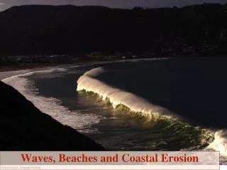
Coastal State Indicators for Coastal Erosion . James Sutherland HR Wallingford. Coastal State Indicators for Coastal Erosion. Indicators used in many fields to assess progress in implementing policy

E N D
Coastal State Indicators for Coastal Erosion James Sutherland HR Wallingford
Coastal State Indicators for Coastal Erosion • Indicators used in many fields to assess progress in implementing policy • Coastal State Indicators are a “reduced set of parameters that can simply, adequately and quantitatively describe the dynamic-state and evolutionary trends of a coastal system.” • Jiménez and van Koningsveld, 2002
Coastal State Indicators for Coastal Erosion Coastal State Indicators (CSIs) should be: • Relevant • Measurable • Responsive to disturbance in known way • Anticipatory • Integrative • Combining data and knowledge of processes to assist in implementing a policy
Coastal State Indicators for Coastal Erosion Functions of Coastal State Indicators: • Assess condition of environment • Compare across situations • Monitor trends • Diagnose problems • Anticipate need for intervention
Coastal State Indicators for Coastal Erosion Coastal State Indicators at Pilot Sites
Coastal State Indicators for Coastal Erosion CSIs used to implement policy
Coastal State Indicators for Coastal Erosion • Policies have implicit physical characteristics • E.g. Hold the line: • Position • Standard of protection
Coastal State Indicators • Dune strength, Barrier width, Backshore width, Dune zone width, Dune zone height, Total barrier volume • Testing coastline, Beach width, Barrier crest position, Shoreline position, • Coastal foundation, Shoreface volume, Coastal slope
Coastal State Indicators Prevention of breaching • Dune strength, Barrier width, Backshore width, Dune zone width, Dune zone height, Total barrier volume
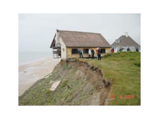
Coastal State Indicators for Coastal Erosion • Dune strength • Erosion during storm
Coastal State Indicators Maintain position • Testing coastline, Beach width, Barrier crest position, Shoreline position,
Coastal State Indicators for Coastal Erosion • Coastline position: Momentary coastline: MCL, Testing Coastline: TCL, Basal Coastline, BCL TCL is CSI (MCL is not) BCL is threshold MCL
Coastal State Indicators • Coastal foundation, Shoreface volume, Coastal slope • Large scale and long term, • Provide boundary conditions for other CSIs, • Coastal foundation is coastal area multiplied by rate of sea level rise, • Coastal slope is an indicator of the relative risk of inundation and the potential rapidity of shoreline retreat.
Coastal State Indicators for Coastal Erosion Why do we need CSIs? • We have data and models • These form evidence for decision making CSIs are appropriate
Coastal State Indicators for Coastal Erosion Why CSIs are appropriate: • Direct link to policy • Communication with policy makers and stakeholders • Skills of coastal managers: • Not numerical modellers • Not necessarily coastal scientists/engineers • Use of resources
Coastal State Indicators • Derived from analysis of system • Understanding state of system • Given a policy to implement • Chosen a means to implement the policy • Require thresholds • Adaptive management
Coastal State Indicators • Are being regularly used at three pilot sites; • Are being developed at the other three. • Not just data • Integrate policy, system understanding and modelling • Usable and communicable