Download
1 / 18
220 likes | 421 Vues
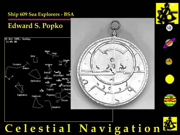
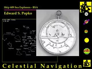
Ship 609 Sea Explorers - BSA Edward S. Popko. C e l e s t i a l N a v i g a t i o n. History of Celestial. Oldest Form of Land / Sea / Air Navigation Early Records Date to 1500BC Used by Arabs for Desert Crossings Kamal and Astrolabe Used in Oceania / Polynesia for 1000 Yrs

E N D
Ship 609 Sea Explorers - BSA Edward S. Popko C e l e s t i a l N a v i g a t i o n
History of Celestial • Oldest Form of Land / Sea / Air Navigation • Early Records Date to 1500BC • Used by Arabs for Desert Crossings • Kamal and Astrolabe • Used in Oceania / Polynesia for 1000 Yrs • Used in Gemini, Apollo, Shuttle Programs • Backup on all Military Ships & Aircraft • Long Line of Incremental Improvements • Sextant: Based on John Davis’s Backstaff 1590 • Time: John Harrison’s Ocean Going Chronometer 1735 • Math and Procedures: Nathaniel Bowditch 1838 • LOPs: John Sumner 1875
Why is Celestial Important? • Essential to Survival at Sea • Critical Backup to Electronic Navigation • Insurance for “Lazy” Piloting and DR Work • Very Useful in Coastal Navigation • Distance Off • 3 Point Fix • Collision Avoidance • Required in Some Sailing Events (Marion/Bermuda..) • Pure Enjoyment • Applied Astronomy • Backpacking/Recreation • Key to History of Ships, Commerce, Warfare, Discovery, Applied Astronomy
What is Celestial Navigation • Exploiting the Regular Motions of Stars and Planets to Determine Where You Are • Every Sighting with a Sextant Results in a Line of Position (LOP) • Lines of Position can be Plotted on a Chart You Are Somewhere on That Line! • The Intersection of Two or More LOPs results in a fix
What Do You Use if For? • Locating Lines of Position, Establishing FIXs • Checking your Speed & Course • Determining Effects of Current and Wind on Boat • Calibrating your Compass
What Do You Use if For? • Locating Lines of Position, Establishing FIXs • Checking your Speed & Course • Determining Effects of Current and Wind on Boat • Calibrating your Compass • Map Making • Backpacking / Survival • Distance-Off • Collision Avoidance • Basic Astronomy
Basic Theory • Every Celestial Body has a Ground Point - GP • You Measure Angle of Body to Horizon • Assume a Location • “Reduce the Sight” • Compare Computed and Assumed Location • Plot Results Every Sight Results in one LOP on your Chart! • Look at the Sun, Moon,Planets &Stars
What Stars Tell Us Every Celestial Body has a Ground Point - GP GP Sextant Angle GP Nautical Almanac had GP for all times every day
Taking a Sight 1 3 What Body are we Looking at? What Time is it? 2 What Angle is it? Sextant Measures Angles - Nothing More!
Basic Procedure • Identify Celestial Body • Measure it’s Height above the Horizon (Sextant) • Time Exact Moment of Sighting • Use Nautical Almanac to find Ground Point of Body • Assume a Position • “Reduce the Sight” • Plot Resulting LOP and Azimuth on Chart • Update Dead Reckoning
A “Celestial Day’s Work” • Morning Twilight Stars for a Fix • Mid-Morning Sun / Moon / Venus • Noon Sun (for Latitude) • Mid-Afternoon Sun / Moon / Venus • Evening Twilight Stars for a Fix • Special LOPs • Coarse • Speed • Longitude • Latitude (Local Noon) • Course Plotting, DR Updates, FIX, Other
What do You Need? • Accurate Watch (You have one) • Sextant (a $20 plastic sextant is fine) • Large Lake or Ocean View or ..... • Dish of Water or Old Motor Oil (All are Free) Makes Artificial Horizon • Nautical Almanac (Must have - $5- get at boat stores) • Small Area Plotting Sheet ( Draw your own chart) • Drafting Items .. Pencils, Protractor (You have them) • Optional Items (You have them) • Calculator • Star Guide from Astronomy Magazine or Newspaper You already have most of the stuff you need.
Demonstrations • A Two Day Boating Cruise • Finding The Camp Site at a State Park (Landlocked)
Fix from Two LOPs C 075 C 075 S 12.5 1500 FIX S 12.5
What Limits Celestial • Must have Clear View of Horizon • Limited Dawn and Dusk Star Fix Window • Using Sextant from Small Pitching Boats • Weather and Sky Visibility • Dawn / Dusk / Daytime Only
How Do You Learn it? • Read Boy Scouts’ “Sea Exploring Manual” • Try Astronomy Merit Badge • Visit a Planetarium (Mystic Sea Port, Haydan...) • Take an Off-Shore Navigation Cruise • Ocean Star from Ocean Navigator Magazine • Teach Yourself in the Back Yard • Plastic Sextant + Artificial Horizon + Back Yard/Camping Site • Take a Class • U.S. Power Squadron. Coast Guard, Marinas etc. • Attend a Boat Show Clinic • Read Astronomy Magazines • Visit a Maritime Museum
What is New after 1500 Yrs.? • Inexpensive Calculators that do all the Math • High-Tech Sextants • Composite Plastics • Very High Quality Mirrors / Scope Optics / Filter Design • Built-in Clocks and Sight Log Memories • Artificial Horizons - Can Sight from Land or at Night • Night Vision Telescopes - Can Sight all Night • Automatic Azimuth/Compass Units • Celestial & Star Calculators • Links to PC Navigation and DR Plotting • Applications in the Space Program • Shuttle, Hubble, “Guide Star” Projects • PC Simulators