Download
1 / 17
170 likes | 360 Vues
History of Celestial. Oldest Form of Land / Sea / Air NavigationEarly Records Date to 1500BCUsed by Arabs for Desert CrossingsKamal and AstrolabeUsed in Oceania / Polynesia for 1000 YrsUsed in Gemini, Apollo, Shuttle ProgramsBackup on all Military Ships

E N D
2. History of Celestial Oldest Form of Land / Sea / Air Navigation
Early Records Date to 1500BC
Used by Arabs for Desert Crossings
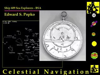
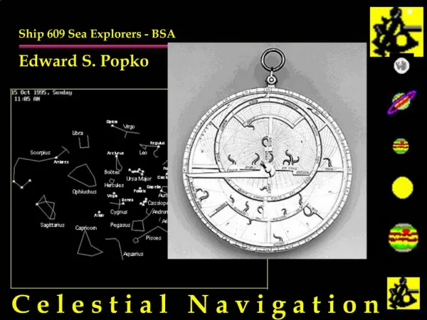
Kamal and Astrolabe
Used in Oceania / Polynesia for 1000 Yrs
Used in Gemini, Apollo, Shuttle Programs
Backup on all Military Ships & Aircraft
Long Line of Incremental Improvements
Sextant: Based on John Davis�s Backstaff 1590
Time: John Harrison�s Ocean Going Chronometer 1735
Math and Procedures: Nathaniel Bowditch 1838
LOPs: John Sumner 1875
3. Why is Celestial Important? Essential to Survival at Sea
Critical Backup to Electronic Navigation
Insurance for �Lazy� Piloting and DR Work
Very Useful in Coastal Navigation
Distance Off
3 Point Fix
Collision Avoidance
Required in Some Sailing Events (Marion/Bermuda..)
Pure Enjoyment
Applied Astronomy
Backpacking/Recreation
Key to History of Ships, Commerce, Warfare, Discovery, Applied Astronomy
4. What is Celestial Navigation Exploiting the Regular Motions of Stars and Planets to Determine Where You Are
Every Sighting with a Sextant Results in a Line of Position (LOP)
Lines of Position can be Plotted on a Chart
You Are Somewhere on That Line!
The Intersection of Two or More LOPs results in a fix
5. What Do You Use if For? Locating Lines of Position, Establishing FIXs
Checking your Speed & Course
Determining Effects of Current and Wind on Boat
Calibrating your Compass
6. What Do You Use if For? Locating Lines of Position, Establishing FIXs
Checking your Speed & Course
Determining Effects of Current and Wind on Boat
Calibrating your Compass
Map Making
Backpacking / Survival
Distance-Off
Collision Avoidance
Basic Astronomy
7. Basic Theory Every Celestial Body has a Ground Point - GP
You Measure Angle of Body to Horizon
Assume a Location
�Reduce the Sight�
Compare Computed and Assumed Location
Plot Results
8. What Stars Tell Us
9. Taking a Sight
10. Basic Procedure Identify Celestial Body
Measure it�s Height above the Horizon (Sextant)
Time Exact Moment of Sighting
Use Nautical Almanac to find Ground Point of Body
Assume a Position
�Reduce the Sight�
Plot Resulting LOP and Azimuth on Chart
Update Dead Reckoning
11. A �Celestial Day�s Work� Morning Twilight Stars for a Fix
Mid-Morning Sun / Moon / Venus
Noon Sun (for Latitude)
Mid-Afternoon Sun / Moon / Venus
Evening Twilight Stars for a Fix
Special LOPs
Coarse
Speed
Longitude
Latitude (Local Noon)
Course Plotting, DR Updates, FIX, Other
12. What do You Need? Accurate Watch (You have one)
Sextant (a $20 plastic sextant is fine)
Large Lake or Ocean View or .....
Dish of Water or Old Motor Oil (All are Free) Makes Artificial Horizon
Nautical Almanac (Must have - $5- get at boat stores)
Small Area Plotting Sheet ( Draw your own chart)
Drafting Items .. Pencils, Protractor (You have them)
Optional Items (You have them)
Calculator
Star Guide from Astronomy Magazine or Newspaper
13. Demonstrations
A Two Day Boating Cruise
Finding The Camp Site at a State Park (Landlocked)
14. Fix from Two LOPs
15. What Limits Celestial Must have Clear View of Horizon
Limited Dawn and Dusk Star Fix Window
Using Sextant from Small Pitching Boats
Weather and Sky Visibility
Dawn / Dusk / Daytime Only
16. How Do You Learn it? Read Boy Scouts� �Sea Exploring Manual�
Try Astronomy Merit Badge
Visit a Planetarium (Mystic Sea Port, Haydan...)
Take an Off-Shore Navigation Cruise
Ocean Star from Ocean Navigator Magazine
Teach Yourself in the Back Yard
Plastic Sextant + Artificial Horizon + Back Yard/Camping Site
Take a Class
U.S. Power Squadron. Coast Guard, Marinas etc.
Attend a Boat Show Clinic
Read Astronomy Magazines
Visit a Maritime Museum
17. What is New after 1500 Yrs.? Inexpensive Calculators that do all the Math
High-Tech Sextants
Composite Plastics
Very High Quality Mirrors / Scope Optics / Filter Design
Built-in Clocks and Sight Log Memories
Artificial Horizons - Can Sight from Land or at Night
Night Vision Telescopes - Can Sight all Night
Automatic Azimuth/Compass Units
Celestial & Star Calculators
Links to PC Navigation and DR Plotting
Applications in the Space Program
Shuttle, Hubble, �Guide Star� Projects
PC Simulators