HWRF/GSI System Setup
AMS 2014 #803Wed Hall C3. Impact of Geostationary Satellite Data on Superstorm Sandy Forecast I. Lateral boundary condition and satellite data impacts. Tong Zhu (CIRA/CSU@NOAA/NESDIS/JCSDA) and Sid Boukabara (NOAA/NESDIS/JCSDA). Abstract.

HWRF/GSI System Setup
E N D
Presentation Transcript
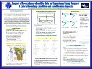
AMS 2014 #803Wed Hall C3 Impact of Geostationary Satellite Data on Superstorm Sandy Forecast I. Lateral boundary condition and satellite data impacts Tong Zhu (CIRA/CSU@NOAA/NESDIS/JCSDA) and Sid Boukabara (NOAA/NESDIS/JCSDA) Abstract Read in and assimilated satellite data OBS numbers by GSI/HWRF a Forecast track uncertainty Figure 4. 5-day forecast tracks with model initialized every 6-hr from 1800 UTC 25 to 1200 UTC 27, 2012 for experiments (a) CNT, (b) WCNT, (c) BIG2, and (d) WBIG2. a b • The forecast track errors increase with the increase of domain-1 size from CNT to BIG2. • The comparisons between CNT and WCNT, or BIG2 and WBIG2 show that the track forecast errors are reduced with the assimilation of satellite data. • The forecast track uncertainty or the STD of track errors are reduced after assimilating satellite data. • The maximum wind and MSLP forecast errors are not affected by the changing of domain-1 size. d c Figure 2. GSI/HWRF read in and assimilated (used) satellite observation numbers for each sensors within one day cycle experiments. HWRF/GSI System Setup The sensor from which the most data assimilated is AIRS, and the next one is AMSU-A data on board N15, N18, N19 and AQUA satellites. In this case, the AIRS data is available at 06Z and 18Z, and the time for most data assimilated is at 06Z. The total numbers of satellite data read in and assimilated are increased by 49.5% and 55.4% when increasing the domain-1 size from control run size big3 size. The number of GEO satellite data (GOES Sounder and MSG SEVIRI) assimilated is about 5.7% of the total assimilation numbers. Experiments Configuration . 1. Without satellite data experiments: CNT1: Control run with FY13 HWRF 20 cycle 5-day simulations from 1800 UTC, 22 to 1200 UTC, 27 October, 2013. SMA1: Same as control run, with D01 size reduced by 700 km in x/y direction. BIG1: Same as control run, with D01 size increased by 700 km in x/y direction. BIG2: Same as BIG1, with D01 size increased by 700 km in x/y direction. BIG3: Same as BIG2, with D01 size increased by 700 km in x/y direction. 2. With satellite data experiments: WCNT: Same as control run, with satellite data assimilated in GSI. WSMA1: Same as SMA1, with satellite data assimilated in GSI. WBIG1: Same as BIG1, with satellite data assimilated in GSI. WBIG2: Same as BIG2, with satellite data assimilated in GSI. WBIG3: Same as BIG3, with satellite data assimilated in GSI. 3. GSI assimilated satellite data includes: AMSUA N15, N18, N19, Metop-a, AQUA; MHS N18, N19, Metop-a HIRS4 Metop-a, N19; IASI Metop-a; AIRS AQUA; SNDR-D1-4 G13, G15 ATMS NPP Figure 5. The 22 forecast cycles averaged forecast track errors w.r.t. GFS operational forecast from five different domain experiments. The solid and dashed curve s are for the experiments without and with the assimilation of satellite data., respectively. • For the 3-5 days forecast, the track errors first increase with the increase of domain size, and then become stable at after BIG2 size (without satellite data) or BIG1 size (with satellite data). • For the 3-5 days forecast, the overall track errors with the assimilation of satellite data are smaller than that without the satellite data runs. • For the forecasts within 2 days, the track errors do not change with the HWRF domain size and with the assimilation of satellite data. Comparison of forecast tracks for CNT and WCNT Track forecasts for CNT and WCNT experiments, and compared with Best Track and GFS forecast The geostationary satellite sensors can provide high spatial and temporal resolution observations, which are great benefit in monitoring and forecasting severe weather events. To optimize the usage of geostationary satellite data in numerical weather prediction and study the potential impact of the Joint Polar Satellite System (JPSS) data coverage gap, the impact experiments were designed with the simulation of Superstorm Sandy by the Hurricane Weather Research and Forecasting Nonhydrostatic Multiscale Model (HWRF). Before study the GEO satellite data impacts, we first evaluated the impact of lateral boundary condition on the Superstorm Sandy forecast skill, as well as the impact of the assimilation of all satellite data used by GSI. A series of HWRF sensitive experiments were performed. In the first group of experiments, 5 different HWRF domain-1 sizes were employed for performing forecasts without the assimilation of satellite data. The second group experiments were the same as first group’s but with the assimilation of satellite data. It was found that, for the 3-5 days forecasts, the track errors increased with the increase of domain-1 size up to BIG2 size for the experiments without satellite data, and the track errors increased up to BIG1 experiments with the assimilation of satellite data. The forecast track errors were reduced with the assimilation of satellite data. The uncertainty of forecast track errors (STD) were reduced after assimilating satellite data. The maximum wind and MSLP forecast errors were not affected by the changing of domain-1 size. These results indicates that the lateral boundary condition impact decreases with the increase of HWRF domain size, and the impact is reduced after assimilating satellite data. Five different domain-1 sizes and satellite data coverage Summary and Future Plan • Summary: • Ten HWRF sensitive experiments were performed with the increased or decreased domain-1 size, and with and without the assimilation of satellite data. • The analysis of the track forecast errors and uncertainties shows that: • For the 3-5 days forecasts, the track errors increased with the increase of domain-1 size up to BIG2 for the experiments without satellite data, and the track errors increased up to BIG1 experiments when assimilating satellite data. • The forecast track errors were reduced with the assimilation of satellite data. • The uncertainty of forecast track errors (STD) were reduced after assimilating satellite data. • The maximum wind and MSLP forecast errors were not affected by the changing of domain-1 size. • The lateral boundary condition impact decreases with the increase of domain size, and become stable after big1 or 2 size. The boundary condition impact is reduced after assimilating satellite data. • Future Plans: • Improve the use of GSI assimilation procedure in HWRF system by taking account of high density satellite data within HWRF domain. • More case studies for the boundary condition impacts need to be conducted. • Study the impacts of the assimilation of GOES and SEVIRI on HWRF forecast. Figure 3. Five-day track forecasts from CNT and WCNT experiments, and also compared with GFS operational forecast and Best track, initialed at (a) 1800 UTC 22, (b) 1200 UTC 23, (c) 1200 UTC 24, (d) 1200 UTC 25, (e) 1200 UTC 26, and (f) 1200 UTC 27, 2012. The tracks forecasted by CNT and WCNT experiments are similar during most time. For a few times, such as 1200 UTC 25, the forecasted track errors are smaller for the experiment with the assimilation of satellite data. In general, GFS operational forecast show better track forecast skill than that of HWRF forecast, because a globe model can capture better large scale flow patterns. The intensity forecasts (Max. wind and MSLP) for CNT and WCNT experiments is better than that of GFS forecast. Acknowledgements The authors want thank Drs. Banglin Zhang , Qingfu Liu and Mingjing Tong for their help and useful discussion and suggestion in using HWRF. Figure 1. Five HWRF domain-1 sizes (SMA, CNT, BIG1, BIG2, and BIG3) and the satellite data coverage from eight different sensors at 1800 UTC, 22 October 2012.