Download
1 / 40
400 likes | 416 Vues
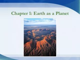
Explore the layered sphere of the Earth, tectonic plate movements, rock types, sedimentation, mineral resources, environmental effects of extraction, and natural hazards like volcanoes and landslides.

E N D
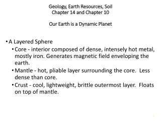
Geology, Earth Resources, SoilChapter 14 and Chapter 10Our Earth is a Dynamic Planet • A Layered Sphere • Core - interior composed of dense, intensely hot metal, mostly iron. Generates magnetic field enveloping the earth. • Mantle - hot, pliable layer surrounding the core. Less dense than core. • Crust - cool, lightweight, brittle outermost layer. Floats on top of mantle.
Earth’s Cross Section • Upper layer of mantle contains convection currents that break overlying crust into a mosaic of tectonic plates. • Slide slowly across earth’s surface • Ocean basins form where continents crack and pull apart. • Magma (molten rock) forced up through the cracks forms new oceanic crust that piles up underwater in mid-ocean ridges. FIGURE 14.2
Tectonic Processes • Upper layer of mantle contains convection currents that break overlying crust into a mosaic of tectonic plates. • Slide slowly across earth’s surface • Ocean basins form where continents crack and pull apart. • Magma (molten rock) forced up through the cracks forms new oceanic crust that piles up underwater in mid-ocean ridges.
Tectonic Plates FIGURE 14.3
Tectonic Processes • Earthquakes are caused by grinding and jerking as plates slide past each other. • Mountain ranges pushed up at the margins of colliding plates. • When an oceanic plate collides with a continental landmass, the continental plate will ride up over the seafloor and the oceanic plate will subduct down into the mantle where it melts. • Deep ocean trenches mark subduction zones.
Tectonic Plate Movement FIGURE 14.4
Rocks and Minerals A mineral is a naturally occurring, inorganic, solid element or compound with a definite chemical composition and regular internal crystal structure. FIGURE 14.7
Rock Types • A rockis a solid, cohesive, aggregate of one or more minerals. • Each rock has a characteristic mixture of minerals, grain sizes, and ways in which the grains are mixed and held together. • Rock Cycle - cycle of creation, destruction, and metamorphosis • Three major rock classifications: • Igneous • Sedimentary • Metamorphic
Rock Cycle FIGURE 14.8
Rock types Igneous rock--Most common type of rock in Earth’s crust. Ex: Granite Metamorphic Rock-Preexisting rocks modified by heat, pressure, and chemical agents • Marble (from limestone) • Quartzite (from sandstone) • Slate (from mudstone and shale) Sedimentary Rock--Deposited materials that remain in place long enough, or are covered with enough material for compaction, may again become rock. Examples: Sandstone, shale
Weathering and Sedimentation • Mechanical weathering - physical break-up of rocks into smaller particles without a change in chemical composition • Chemical weathering - selective removal or alteration of specific components that leads to weakening and disintegration of rock • Oxidation • Hydrolysis • Sedimentation - deposition of particles of rock transported by wind, water, ice and gravity until they come to rest in a new location
Sedimentary Rock The sedimentary rock of Bryce Canyon National Park has been carved by erosion into tall spires. FIGURE 14.10
Economic Geology and Mineralogy Metals • Metals consumed in greatest quantity by world industry • Iron • Aluminum • Manganese • Copper and Chromium • Nickel
Non-Metal Mineral Resources • Gemstones and Precious Metals • Their monetary value bankrolls despots, criminal gangs, terrorism, inhumane labor conditions. • Sand and Gravel - greatest volume and dollar value • Brick and concrete construction, paving, sandblasting • Glass production • Rare earth elements—ex: neodymium-often used in modern technology
Environmental Effects of Mineral Extraction • Disturbance or removal of land surface • 80,000 metric tons of dust • >100 Toxic air pollutants • Chemical and sediment runoff • When sulfide ores are exposed to air and water, they produce sulfuric acid. • Vast quantities of ore must be crushed and washed to obtain small quantities of metal; enormous amounts of freshwater are thereby contaminated with acid, arsenic, heavy metal.
Seismic Map of Earthquake Risk in the US On Last page of Ch: Data Analysis
Volcanoes • Volcanoes and undersea magma vents are the sources of most of the Earth’s crust. • Many of world’s fertile soils are weathered volcanic material. • Nueesardentes - deadly clouds of hot gas and ash like those that destroyed Pompeii, temperatures exceed 1000oC,they move at 60 mph and can kill in minutes. • Mudslides often accompany eruptions. • Volcanic dust and sulfur emissions reduce sunlight and temperature around the globe.
Volcanic eruption FIGURE 14.22
Landslides • Landslides are examples of mass wasting, in which geologic materials are moved downslope from one place to another. • Can be slow and subtle or swift as in rockslides and avalanches • Road construction, forest clearing, cultivation, and building on steep, unstable slopes increase the frequency and damage done by landslides.
Landslide in Laguna Beach, California FIGURE 14.23
Soils are Complex Ecosystems • Soil is a renewable resource that develops gradually through the weathering of rocks and the accumulation of organic material. • The accumulation of topsoil is a very slow process. Under the best circumstances it accumulates at a rate of about 1 mm/year. • With careful management, soil can be replenished and renewed indefinitely. • Most farming techniques deplete soil through erosion and removal of organic material. • Severe erosion rates can exceed 25 mm soil /year.
6 Components of Soil • Sand and gravel • Silts and clays • Dead organic material • Soil fauna and flora • Water • Air
Variation in Soil Composition • Variation in the 6 components of soil can produce an almost infinite variety of soil types. • Soil texture (the amount of sand, silt and clay in the soil) is the most important characteristic of soils. • Loam soils are considered best for agriculture because they are a mixture of sand, silt and clay. • The rich, black soils of the central US are rich in nutrients and organic material and contain a mixture of sand, silt and clay to hold moisture well
Sand, Silt, and Clay FIGURE 10.2
Soil Texture Pyramid FIGURE 10.3
Grassland vs. Tropical Rainforest Soils FIGURE 10.4
Soil Fauna Determine Fertility • Soil bacteria, algae and fungi decompose leaf litter making recycled nutrients available to plants. • Tiny worms including nematodes process organic material and create air spaces as they burrow. • Larger insects, spiders and mites loosen and aerate the soil as well. • Mycorrhizal symbiosis, an association between plant roots and certain fungi. The plant feeds the fungus and the fungus provides water and inorganic nutrients to the plant enhancing growth.
Soil Ecosystems FIGURE 10.5
Soils are Layered • Soils are stratified into horizontal layers called soil horizons. • Horizons taken together make up the soil profile. • O Horizon (Organic layer) • Leaf litter, most soil organisms and partially decomposed organisms • A Horizon (Surface soil) • Mineral particles mixed with organic material
E Horizon (washed out) • Depleted of soluble nutrients • B Horizon (Subsoil) • Often dense texture due to clays • C Horizon • Weathered rock fragments with little organic material • Parent Material is the mineral material on which the soil is built, can be bedrock FIGURE 10.6
Food Comes from the A Horizon • Because soils are so important to our survival, we identify soils largely in terms of the thickness and composition of their upper layers. • In the farm belt, the soils have a thick, organic-rich A-Horizon which developed from deep, dense roots when this land was covered by prairie grasslands. • Soils developed in deciduous forests have a thinner A-Horizon and less organic material. • These 2 make up most of the soil in the farming areas of the US
Ways We Use and Abuse Soil • Approximately 11% of the earth’s land area is currently in agricultural production. • Much more could potentially be converted to agricultural use. • However, much of this additional land has issues such as steep slope, soggy soil, is too cold, too dry or has too much salt. • The ecological effects of converting these lands to agriculture include loss of biodiversity, clean water and other ecological services provided by these grasslands or forests.
Arable Land • Arable land is land suitable for agriculture and growing crops. Its unevenly distributed across the world. The best farming occurs in moderate climates with thick fertile soils. • North America and Europe are particularly well suited to growing • Gains in agricultural production have come from increased fertilization, pesticides and irrigation rather than more land.
Soil Losses Cut Farm Production • Every year, about 3 million hectares of cropland worldwide are made unusable by erosion and another 4 million hectares are converted to non-agricultural uses. • Most land degradation happens slowly as soil washes or blows away, salts accumulate and organic matter is lost. • As a consequence of these processes, as well as increases in world population, arable lands worldwide have shrunk from 0.38 ha/person in 1970 to 0.21 ha/person in 2010.
Water Moves Soil in Various Ways • Sheet Erosion - thin layer of surface removed • Rill Erosion - small rivulets of running water gather together and cut small channels • Gully Erosion - rills enlarge to form bigger channels too large to be removed by normal tillage • Stream bank Erosion - washing away of soil from banks of streams and rivers
Wind erosion FIGURE 10.9
Excess wind and water erosion in the US FIGURE 10.8
Desertification - conversion of productive land to desert • Intensive farming practices responsible for erosion: • Row crops leave soil exposed • Weed free-fields • Removal of windbreaks • No crop-rotation or resting periods for fields • Continued monoculture cropping can increase soil loss tenfold
Deserts are Spreading • Desertification of productive lands threatens 1/3 of the earth’s surface and over 1 billion people • Rangelands and pastures are highly susceptible (overgrazing, soil degradation). • Africa and China are of particular concern. • Rapid population growth and poverty create unsustainable pressures. • Removal of trees for fodder and firewood triggers climate change that spreads desertification.