Download
1 / 4
50 likes | 219 Vues
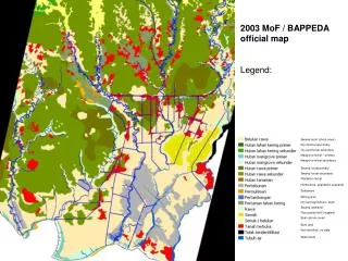
2003 MoF / BAPPEDA official map Legend:. Swamp bush (shrub cover) Dry land forest primary Dry land forest secondary Mangrove forest – primary Mangrove forest secondary S wamp forest primary Swamp forest secondary Plantation forest

E N D
2003 MoF / BAPPEDA official map Legend: Swamp bush (shrub cover) Dry land forest primary Dry land forest secondary Mangrove forest – primary Mangrove forest secondary Swamp forest primary Swamp forest secondary Plantation forest Horticulture (plantation cropland) Settlement Mining area Dry land agriculture / bush Swamp (wetland) Rice paddy field (irrigated) Bush (shrub cover) Bare land Not identified , no data Water body
2007 SarVision draft map Test PALSAR 100m Legend:
2003 Remote Sensing Solutions Gmbh ESA GMES Project (published 2006!) Legend: Source: http://www.informus.de/gsefm_resources/ Documents/GSEFM_T2_S6_Ph1_RSS_MASLI.pdf
2006 – mid-2007 Fires Fire hotspot data from MODIS and ATSR NASA/ University of Maryland, ESA/ESRIN Legend: Red dot: represents fire hotspot detected in the center of approx. 1km pixel