Integrated Framework for Cartographic Reference System Development and Management
The State-Region Agreement on the State Cartographic Reference System (SCR) facilitates coordinated development of essential geographical databases for public administration at all levels. Established through agreements in 1996 and 2000, this framework involves collaboration between various ministries and national mapping agencies. It promotes the creation and distribution of critical geographical data, including digital terrain models, orthoimagery, and vector layers. Accessible through web platforms, the SCR aims to enhance geospatial data management and environmental monitoring while ensuring free public access.

Integrated Framework for Cartographic Reference System Development and Management
E N D
Presentation Transcript
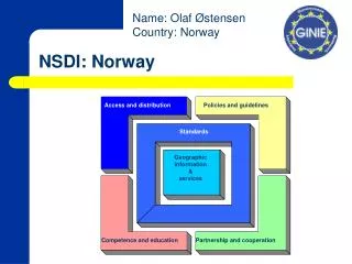
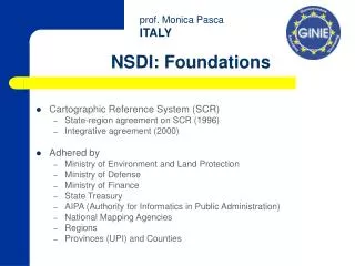
NSDI: Foundations • Cartographic Reference System (SCR) • State-region agreement on SCR (1996) • Integrative agreement (2000) • Adhered by • Ministry of Environment and Land Protection • Ministry of Defense • Ministry of Finance • State Treasury • AIPA (Authority for Informatics in Public Administration) • National Mapping Agencies • Regions • Provinces (UPI) and Counties
NSDI: SCR • National Mapping Agencies • Military Geographical Institute (IGM) • Navy Hydrographical Institute (IIM) • Air Force Geo-topographical Informative Center (CIGA) • Cadastre (Ministry of Finance) • SCR • Technical Co-ordination Body (CTC) • Steering Committee • Co-ordination by • Ministry of Environment and Land Protection
NSDI: SCR Fundamental basis • State and Regions agree on the necessity to concentrate all efforts towards co-ordinated development of Geographical databases essential for the creation of the informative geographical systems of the Public Administrations at national, regional and local level • Production of • Technical specifications • Data compliant with technical specifications • Activities aiming to publish and make available the geographical information (catalogue)
SCR: Technical specifications • Database for fundamental Reference Layers (1:10.000) • Digital Terrain Model (DTM) • Density Increase of the Fundamental Network IGM 95 • Topographical Database of General Interest (work in progress)
SCR: Data • Raster Cartography at national level (1:10.000 to 1:25.000) • Orthoimaginery B/W and colour (1:10.000) – (1:2.000 for most relevant cities) • Digital Terrain Model (Grid and TIN) • Vectorial layers: • Administrative boundaries • Hydrological Grid and Basins • Railways and Motorways grid • Gazetteer • Urban Center and Residential areas
SCR • Metadata Catalogue of existing GI • Geodetic Reference Cartographic System • WGS 84 – UTM 32-33 • Conversion algorithms from previous systems (IGM) • Progressive deadlines • 31.12.2001 • 31.12.2003 • 31.12.2006
SCR: Federal Infrastructure • Distributed Databases • One access for the user • Data remains in the database of the “producer and Custodian”
SCR : Funding • National funding • Ministry of Economy (Treasury – Finance) • Ministry of the Environment and Land Protection • Financial Law • E-governement • Technological Innovation • International funding • European Commission • PON • Objective 1 Regions
SCR : Access to information • Administrations within the SCR • Free of charge • Public Administrations out of the SCR • They can adhere also with their data • Free of charge once a Public administration has already paid the geographic of information or data • Citizens • Web access for consultation • Web access for use (not download)
Web site: Geographical research Geographic search of an area Alphanumeric search of an area
Web site: Geographical research (2) Visualization of the selected areas Result of the geographic query and selection of the interesting areas
Visualisation of the information for the selected area Informative layers for the selected municipalities Full-extent of the selected municipalities
Query Visualisation of all “CORSO” in the layer strato STRADE
Sito WEB Query
GPS Mobile phone with GPRS or GSM Connetting cable Palm Computer SDI for environmental monitoring and control Personal Digital Assistant (PDA). Project by ANPA (National Agency for Environmental Protection) and Ministry for Environment and Land Protection