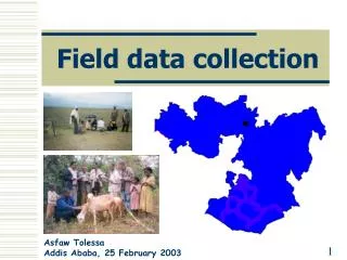
Field Data Collection Protocols
This short course on GIS and field data collection focuses on conservation efforts aimed at saving elephants by helping local communities. Participants will learn to navigate and map crucial resources in project areas using various tools, including GPS and digital cameras. Safety procedures, data collection methods, and emergency protocols will be emphasized. Engaging with topographic and satellite maps, trainees will develop essential skills for effective resource allocation and decision-making in conservation efforts.

Field Data Collection Protocols
E N D
Presentation Transcript
Field Data Collection Protocols Saving Elephants By Helping People GIS Resource Mapping Chandeep Corea GISSL-SLWCS-SCGIS –Conservation GIS Short Course
Saving Elephants By Helping People • GIS Resource Mapping • KIT NEEDED • Datasheets “GPS Survey”, “GPS Geo-Referencing Form” & “Transect Form” • This sheet • 1 clipboard + pencil • 1 GPS + spare batteries • 1 Digital Camera (make sure battery is at least ¾ full and CF cards are empty) • SAFETY & EMERGENCY PROCEDURES • Remember to sign in and out of the logbook. • If you have an accident / emergency:You should take the casualty to the closest clinic, the village nearest the core study site. Once on the way to the clinic, call them and describe the incoming casualty’s injuries so that they know what to prepare for. As soon as possible after the casualty is evacuated, call Chandeep. If in the park make sure that You inform the park authorities before you leave the park. • Phone numbers: Chinthaka (072-5463377), Upul (072-4653473), Field House (0665675888), Field Camp (072-573536),Chandeep (0777885330), Willy’s Hotel (landline) 0662234268 (mobile) 0722555777. Clinic Hettipola (landline Dr. Prasanna) 0662250061.
NOTES ON COMPLETING THE • Activity and Data Collection • The purpose of the GIS Survey work is to map out various features in the project areas so that effective decisions can be made on resource allocation and prioritization. • The process to follow is meant to give us meaningful data that can be effectively used for the successful implementation of the project. • BEFORE STARTING FIELD WORK • Look at Topographic Sheet #49, and 43 along with any other maps provided by local authorities. • Look for road intersections, bridges, river forks, reservoirs and similar locations which are clearly visible. • Look at the satellite images for the area to help orient yourself. • IN THE FIELD • There are 3 activities to do, all of which end with time at the field site entering data. These will be done both independently as a part of other work where a few people will be assigned to focus only on this.
*GPS Geo-Referencing: The purpose is to correctly position maps and other images (satellite imagery and aerial photographs) to roads, rivers and other important features. • Fill out the survey sheet as in the example below. • Make sure you mark the waypoint number on the topographic sheet as well. • When marking reservoirs make sure you take a waypoint at the start and end of the road that goes along it or if going parallel to it just take a waypoint at the center. • Mark all schools, police stations, hospitals, temples, gas stations and government buildings. • Tale photographs of any interesting sites (nice view points, waterfalls, unique building, statues etc) The above should be done for the entire study area as part of the travel within it for other work.