Rapid Refresh and RTMA
Rapid Refresh and RTMA. RUC: AKA-Rapid Refresh. A major issue is how to assimilate and use the rapidly increasing array of off-time or continuous observations (not a 00 and 12 UTC world anymore! Want very good analyses and very good short-term forecasts (1-3-6 hr)

Rapid Refresh and RTMA
E N D
Presentation Transcript
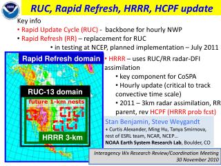
RUC: AKA-Rapid Refresh • A major issue is how to assimilate and use the rapidly increasing array of off-time or continuous observations (not a 00 and 12 UTC world anymore! • Want very good analyses and very good short-term forecasts (1-3-6 hr) • The RUC/RR ingests and assimilates data hourly, and then makes short-term forecasts • Uses the WRF model…which uses a hybrid sigma/isentropic vertical coordinate • Resolution: Rapid Refresh: 13 km and 50 levels, High Resolution Rapid Refresh (3 km)
Rapid Refresh andHRRR NOAA hourly updated models 13km Rapid Refresh (RAP) (mesoscale) Version 2 – scheduled NCEP implementation Q2 (currently 28 Jan) RAP 3km HRRR (storm-scale) HRRR High-Resolution Rapid Refresh Scheduled NCEP Implementation Q3 2014 NCEP Production Suite Review Rapid Refresh / HRRR 3-4 December 2013
RAPv2Prediction System Overview • Hourly updated mesoscale analyses / forecasts • WRF-ARW model (Grell-3 cumulus param, Thompson microphysics, RUC-Smirnova land-surface, MYNN PBL scheme) • GSI hybrid analysis using 80-member global ensemble • 13-km, 50 levels, 24 cycles/day – each run out to 18 hours • 6-hour catch-up “partial” cycle run twice per day from GFS • Output grids: 13, 20, and 40 km CONUS, 32 km full domain, 11 km Alaska, 16 km Puerto Rico • Use and downstream dependencies • Used by SPC, AWC, WPC, NWS FOs, FAA, energy industry, and others for short-range forecasts and hourly analyses • Downscaled RAP serves as first guess for RTMA • RAP serves as initial condition for SREF members • RAP will be used to initialize Hi-Res Rapid Refresh (HRRR)
Observations Used Rapid RefreshHourly Update Cycle Partial cycle atmospheric fields – introduce GFS information 2x/day Cycle hydrometeors Fully cycle all land-sfc fields (soil temp, moisture, snow) 1-hr fcst 1-hr fcst 1-hr fcst Back- ground Fields Analysis Fields 3DVAR 3DVAR Obs Obs Time (UTC) 11 12 13
RAPv2Hybrid Data Assimilation 13 km RAP Cycle 14z 13z 15z 80-member GFS EnKF Ensemble forecast valid at 15Z (9-hr fcst from 6Z) ESRL/GSD RAP 2013 Uses GFS 80-member ensemble Available four times per day valid at 03z, 09z, 15z, 21z Obs Obs Obs GSI Hybrid GSI Hybrid GSI Hybrid 1 hr fcst HM Obs HM Obs HM Obs 1 hr fcst GSI HM Anx GSI HM Anx GSI HM Anx Refl Obs Refl Obs Refl Obs Digital Filter Digital Filter Digital Filter 18 hr fcst 18 hr fcst 18 hr fcst
RUC History – NCEP (NMC) implementations • - First operational implementation of RUC • - 60km resolution, 3-h cycle • 1998 – 40km resolution, 1-h cycle, • - cloud physics, land-sfc model • 2002 – 20km resolution • - addition of GOES cloud data in assimilation • 2003 – Change to 3dVAR analysis from previous OI • (April) • 2004 – Vertical advection, land use (April) • PBL-depth for surface assimilation (September) • 2005 – 13km resolution, new obs, new model physics • (June) • 2011 – WRF-based Rapid Refresh w/ GSI to replace RUC
RTMA(Real Time Mesoscale Analysis System) NWS New Mesoscale Analysis System for verifying model output and human forecasts.
Real-Time Mesoscale Analysis RTMA • Downscales a short-term forecast to fine-resolution terrain and coastlines and then uses observations to produce a fine-resolution analysis. • Performs a 2-dimensional variational analysis (2d-var) using current surface observations, including mesonets, and scatterometer winds over water, using short-term forecast as first guess. • Provides estimates of the spatially-varying magnitude of analysis errors • Also includes hourly Stage II precipitation estimates and Effective Cloud Amount, a GOES derived product • Either a 5-km or 2.5 km analysis.
RTMA • The RTMA depends on a short-term model forecast for a first guess, thus the RTMA is affected by the quality of the model's analysis/forecast system • CONUS first guess is downscaled from a 1-hour RR forecast. • Because the RTMA uses mesonet data, which is of highly variable quality due to variations in sensor siting and sensor maintenance, observation quality control strongly affects the analysis.
Why does NWS want this? • Gridded verification of their gridded forecasts (NDFD) • Serve as a mesoscale Analysis of Record (AOR) • For mesoscale forecasting and studies.