Download
1 / 38
380 likes | 403 Vues
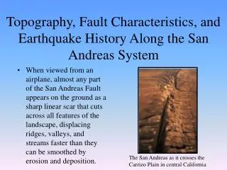
Explore the intricacies of seismic activities in California, from the Big Bend in the San Andreas Fault to the different fault types, historic earthquakes, and their impacts. Learn about seismic waves, measuring earthquakes, and more.

E N D
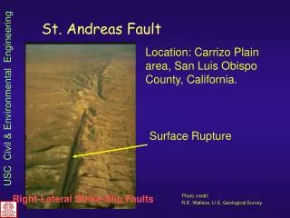
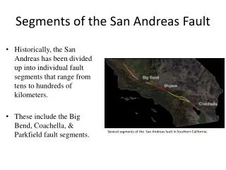
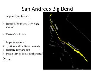
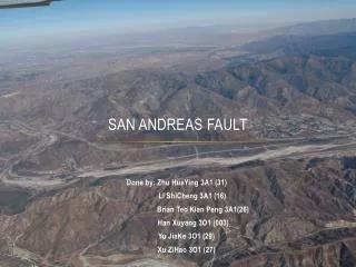
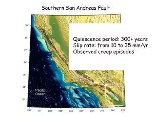
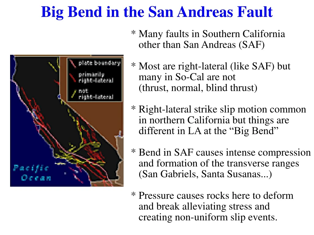
Big Bend in the San Andreas Fault * Many faults in Southern California other than San Andreas (SAF) * Most are right-lateral (like SAF) but many in So-Cal are not (thrust, normal, blind thrust) * Right-lateral strike slip motion common in northern California but things are different in LA at the “Big Bend” * Bend in SAF causes intense compression and formation of the transverse ranges (San Gabriels, Santa Susanas...) * Pressure causes rocks here to deform and break alleviating stress and creating non-uniform slip events.
North America Plate Pacific Plate Big Bend in the San Andreas Fault Right-lateral strike-slip motion along the SAF becomes compressional at a bend in the fault line.
CSUN Parking Structure Northridge Earthquake, 1994 - January 17, 1994, 4:30 am - Magnitude = 6.9 - Blind thrust fault - Difficult to find or predict - Duration 10-20 seconds
EarthquakesChapter 16 1989, Loma Prieta earthquake, Mw = 7.2
Historic Earthquakes 1906 San Francisco (7.8) - 280 miles of displacement - Shaking ~1 minute - Damaged water mains, fires spread and caused many deaths (3000).
Historic Earthquakes 1989 Loma Prieta, Mw = 7.2 - Shaking for 15 seconds - Death toll 63
Historic Earthquakes 1964 southern Alaska (Mw = 9.2) - Shaking for 3 minutes - Rupture 350,000 square miles - Death toll from quake 15 (remote area) - Tsunami, landslides 100 more
Historic Earthquakes 1994 Northridge - 1.8 miles from CSUN - Shaking 40 seconds - Damaged all 53 CSUN buildings - Damaged 300 other schools - Lower story buildings collapsed - 4 interstate hwy's closed for months (Golden State, Santa Monica fwys) - 15000 people live in tents for days - 10000 without water, elect, gas - Arid climate did not cause liquifaction of soils – shaking minimized (compared to 1964 Alaska and 1989 Loma Prieta). - Landslides in Santa Susana, Santa Monica, San Gabriel Mtns blocked roads and traffic, damaged water lines and homes in Palisades - Sylmar – Olive View Hospital – rebuilt from 1971 to code stayed intact. - Aftershocks 5.9 1 min after main shock, 5.6 11 hrs after.
Historic Earthquakes 2002 inland Alaska – Denali Fault - Propagated east 7000 miles/hr - Offset streams, glaciers, landslides - Trans-Alaska Oil Pipeline no serious damaged - pre-engineered
Historic Earthquakes 2004 Sumatra – Andaman E.Q. - Mw = 9.3 - Second largest recorded on Earth - Major damage in Sumatra - Tsunami damage spread far to Indonesia, Thailand, Sri Lanka, India, East Africa - Death toll 220,000 from force of tsunami wave
Moon Quakes Moon quakes were recorded by a seismometer from the Apollo 16 mission
INSIGHT Mission to Mars * The INSIGHT missionwill deploy one seismometer to measure Mars quakes! * Do you think this is a good use of our research dollars ? Why or Why not ?
Earthquakes • An earthquake is a trembling or shaking of the ground caused by the sudden release of energy • Tectonic forces produce stresses on rocks that eventually exceed their elastic limits, resulting in brittle failure • Energy is released during earthquakes in the form of seismic waves • Elastic rebound theory - earthquakes are a sudden release of strain stored in rocks that bend until they finally break and move along a fault
Seismic Waves • Focus (or hypocenter) - the point of initial breakage and movement along a fault, where seismic waves originate • Epicenter - point on Earth’s surface directly above the focus • Two types of seismic waves are produced during earthquakes • Body waves - travel outward from the focus in all directions through Earth’s interior • Surface waves - travel along Earth’s surface away from the epicenter
Body Waves • P wave - compressional body wave in which rock vibrates back and forth parallel to the direction of wave propagation • Fast (4 to 7 kms/sec) wave that is the first or primary wave to arrive at recording station following earthquake • Pass through solids and fluids • S wave – shearing body wave in which rock vibrates back and forth perpendicular to the direction of wave propagation • Slower (2 to 5 km/sec) wave that is the secondary wave to arrive at recording station following earthquake • Pass through solids only
Surface Waves Surface waves are slower than body waves but have the larges amplitude • Love waves - side-to-side motion of the ground surface • Can’t travel through fluids • Rayleigh waves - ground to moves in an elliptical path opposite the direction of wave motion • Extremely destructive to buildings
Measuring Earthquakes • Seismometers - used to measure seismic waves • Seismographs - recording devices used to produce a permanent record of the motion detected by seismometers
Measuring Earthquakes • Seismograms - permanent paper (or digital) records of the earthquake vibrations • Used to measure the earthquake strengths
Locating Earthquakes • P- and S-waves leave E.Q. focus at the same time • P-wave gets farther and farther ahead of the S-wave with distance and time from the earthquake • Travel-time curve - used to determine distance to focus • based on time between first P- and S-wave arrivals
Locating Earthquakes • One station gives distance to E.Q. but not direction • Plotting distances from 3 stations on a map, as circles with radii equaling the distance from the quake. Point where 3 circles overlap locates the earthquake epicenter • Depth of focus beneath Earth’s surface can also be determined • Shallow focus 0-70 km deep • Intermediate focus 70-350 km deep • Deep focus 350-670 km deep
Measuring the Sumatra – Andaman Earthquake A Global Seismic Network (GSN) is maintained around the Earth to monitor earthquake activity as well as nuclear testing. Earthquake locations and depth can be determined within minutes of an earthquake using this GSN network.
Measuring the “Size” of Earthquakes • Earthquake “size” measured two ways - intensity and magnitude • Intensity - a measure of the effects an earthquake produces (on both structures and people) • Modified Mercalli scale
Measuring the “Size” of Earthquakes • Magnitude is a measure of the amount of energy released by an earthquake • Richter scale • Body waves • Surface waves • Moment magnitude - more objective measure of energy released by a major earthquake Mo = m* U * A • Uses rock strength, surface area, fault rupture distance • Smaller earthquakes are more common than large ones
Earthquake Magnitudes “How Big is Big ? ” Earthquake magnitudes are logarithmic M = 10 R (M = ground movement, R = Richter scale) If R = 1, then M = 10 If R = 2, then M = 100 So this means that a magnitude 7 earthquake will have 10 times as much ground movement as a magnitude 6 earthquake. Change by 1 Change by 10
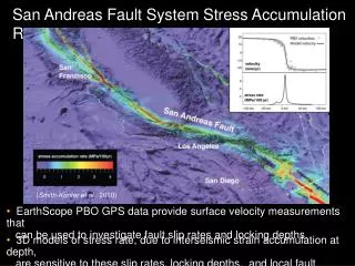
Location and Size of Earthquakes in the U.S. • Earthquakes occur throughout the U.S., but are much more common in the western states and Alaska • Largest seismic risks or hazards exist near the plate boundary along the U.S. Pacific coast (e.g., San Andreas fault), and around New Madrid, Missouri • Seismic risk determined based on the assumption that large future earthquakes will occur where they have occurred in the past Earthquake locations since 1977
Effects of Earthquakes • Earthquakes produce several types of effects, all of which can cause loss of property and human life • Ground motion is the familiar trembling and shaking of the land during an earthquake • Can topple buildings and bridges • Fire is a problem just after earthquakes because of broken gas and water mains and fallen electrical wires • Landslides can be triggered by ground shaking, particularly in larger quakes • Liquefaction occurs when water-saturated soil or sediment sloshes like a liquid during a quake • Permanent displacement of the land surface can also occur, leaving fractures and scarps
World Earthquake Distribution • Most earthquakes occur in narrow geographic belts - plate boundaries • Most important concentrations in circum-Pacific and Mediterranean-Himalayan belts • Shallow-focus earthquakes occur at mid-oceanic ridges
World Earthquake Distribution • Nearly all intermediate- and deep-focus earthquakes occur in Benioff zones - inclined seismic activity associated with descending oceanic plate at subduction E.Q.'s are caused by plate interactions along tectonic plate boundaries Plate boundaries are identified and defined by earthquakes
Earthquakes Tectonics Earthquakes occur at each of the three types of plate boundaries: -At divergent boundaries, tensional forces - shallow-focus quakes on normal faults -At transform boundaries, shear forces - shallow-focus quakes along strike-slip faults -At convergent boundaries, compressional forces produce shallow- to deep-focus quakes along reverse faults
First Motion of Ground Motion Observed on a Seismogram Extension (normal faults) Compression (thrust faults)
Building Codes for Earthquakes Best materials are: -Strong -Flexible -Light Good examples: Steel Wood Reinforced concrete (rebar steel core) Poor examples: Simple concrete Brick – chimneys often fall (in moderate E.Q.'s) Heavy roofs (Tile) Strong liquefaction can supersede all these precautions... 1999, Izmit Turkey 1964 Niigata, Japan - liquifaction
Buildings and Bridges... 1995 Kobe, Japan Elevated highway knocked over by strong horizontal jolt. Damage to bridge and 88,000 buildings costs exceeded $400 billion
Tsunami Waves Created by Earthquakes Tsunami waves are generated by submarine earthakes Long low waves are formed above displaced seafloor that travel for miles along the base of the seafloor. Displacement of seawater surface can be as little as a few centimeters in the middle of the ocean. Displacements increase dramatically as they approach a continental shelf
Tsunami Travel time in the Pacific Ocean Earthquake in Alaska may form a tsunami in the Pacific