Big Bend
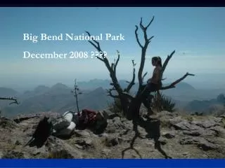
Big Bend. By Nathan Curtis. What year did Big Bend become an official National park and why. Big bend became a national park on June 20 th 1993. It was created to preserve the beauty of the American wilderness and to protect the heritage.


Big Bend
E N D
Presentation Transcript
Big Bend By Nathan Curtis
What year did Big Bend become an official National park and why • Big bend became a national park on June 20th 1993. It was created to preserve the beauty of the American wilderness and to protect the heritage. • Big Bend National Park protects and preserves 801,000 acres of land in the State of Texas. The park, exhibiting the best Chihuahuan Desert expanse in the United States, shares a 118-mile border with the Mexican states of Coahuila and Chihuahua. • The park preserves three distinct ecosystems; riparian, desert, and mountain. Differences in elevation, rainfall, and temperature throughout the park have created the biological diversity found here. There are 450 species of birds, 75 species of mammals, 3600 species of insects and more than 1500 species of plants protected within the park’s boundaries.
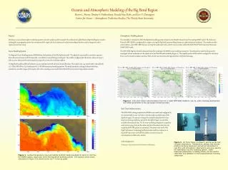
How was the park formed(From science perspective) • In the heart of Big Bend National Park lie the Chisos Mountains, mountains born of fire during volcanic eruptions 40 - 60 million years ago. • Big Bend’s desert landscape itself is a study in contrasts—mesas, mountains, and dikes formed by volcanic activity, limestone ridges and cliffs formed 100 - 200 million years ago when shallow seas covered the area, and ever-changing arroyos, dry most of the year, but subject to violent flash flooding during summer rains.
What types of rocks can be found in inside Big Bend • The types of tocks found inside big bend are sandstone/marlylimestone/chalk limestone/clay sandstone.
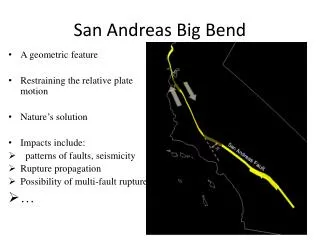
What special landforms or features are inside Big Bend • Along a stretch beginning upstream of Rio Grande Village, a series of thermal springs emerge adjacent to the Rio Grande. All of the hot springs in this region are believed to be related to normal faults. These Basin and Range type faults formed between 18 and 23 million years ago. Today, groundwater circulating deep in the earth becomes heated before it returns to the surface as hot springs. • The Rio Grande is the defining feature of the Big Bend. It is here that the river swings abruptly to the northeast after flowing south and southeast for nearly 1,000 miles. • There are over 200 miles of hiking trails throughout Big Bend National Park. Some are primitive, such as the Marufo Vega Trail, while the trail system in the High Chisos is well marked and maintained.
How is the land inside Big Bend currently changing • It is currently not changing right now. The only thing changing in Big Bend is the climate. • The park now manages fire as a critically important natural process that is allowed to resume its original role in crafting and influencing the plant and wildlife communities of the national park. The task is to manage the natural process of fire in ways that avoid negative impacts on resources and do not threaten human life and property.
What environmental issues are affecting Big Bend? • Prior to the establishment of Big Bend in 1944, much of the land now considered a park was owned by small family ranches and farms. Once established as a national park, a great number of ranches had over-used the land. Currently, the National Park Service is still keeping up with damage that was done to the land many years ago. The impacts of erosion are obvious in some locations in Big Bend National Park. Root systems of plants, like this mesquite, that were once 10 feet underground now stand 10 feet tall above the ground. • The most well known and longest lasting invasive species in the park is Saltcedar, also known as Tamarisk. These trees were introduced to much of the desert southwest in the early 1900s as windbreaks and to lessen the impacts of soil erosion. Ironically, it is this plant that has caused some of the worst erosive features on the Rio Grande. What’s worse, this tree is known to evaporate significant amounts of water. Equally depressing is the rate of spread for this plant, which has been known to resist cold temperatures, fire, floods, and drought.
How is technology used to help preserve and maintain the park • Founded in 1996, the “Friends of Big Bend national Park” a private not-for-profit organization with a mission to support, promote, and raise funds for Big Bend National Park in partnership with the National Park Service and other supporters who value the unique qualities of this national resource on the Rio Grande. The Friends of Big Bend National Park has funded a range of critical projects, including wildlife research programs, the purchase of equipment to monitor air and water quality, and the construction and renovation of Park infrastructure. • Big Bend National Park has one of the most comprehensive recycling programs in the National Park Service and the State of Texas. Started in the late 1990s, it has grown to the point where independent audits estimate that over 90% of recyclable materials, and 40% of the park’s total waste stream, are now being recycled • Modern technology offers a wide array of opportunities to bring the resources of Big Bend to virtual visitors who may never make it to remote West Texas through images, audio, and video.
Bibliography • www.nps.gov