Ch 9/10 Earth’s Water
1.2k likes | 1.52k Vues
Ch 9/10 Earth’s Water. Lesson 1. The Hydrosphere and the Water Cycle. Think About It…. Why is it that the water in your bottle could have been drunk by George Washington?. Focus Question…. What is the structure and functioning of the hydrosphere?. The Hydrosphere…. A. The hydrosphere is…

Ch 9/10 Earth’s Water
E N D
Presentation Transcript
Lesson 1 The Hydrosphere and the Water Cycle
Think About It… Why is it that the water in your bottle could have been drunk by George Washington?
Focus Question… What is the structure and functioning of the hydrosphere?
The Hydrosphere… A. The hydrosphere is… • the water on and in Earth’s crust B1. The percentage of water found in the oceans… • 97 • We don’t call ourselves the Blue Planet for nothing! B2. The percentage of water contained by the landmasses… • 3 http://www.earthview.pair.com/earth300color.jpg
C. Of the Freshwater on Earth… 1. 90% is in the form of… • polar ice caps and glaciers 2. Most of the remaining water is… • groundwater 3. Only a small fraction is in… • rivers, streams, and lakes Alaska’s Glacier Bay http://adventure.nationalgeographic.com/adventure/trips/family-trips/glacier-bay-alaska/
The World’s Water Supply… • Oceans – 97.2% - thousands of years • Ice caps and glaciers – 2.15% - tens of thousands of years • Groundwater - .31% - hundreds to thousands of years • Lakes - .009% - tens of years • Atmosphere - .001% - nine days! • Rivers and streams - .0001% - two weeks
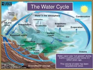
The Water Cycle… 1. The Water Cycle… a. oceans b. groundwater 2. It returns to the surface and to the ocean
Runoff… • Runoff is… • water flowing down slope along Earth’s surface http://myecoproject.org/wp-content/uploads/2009/02/stormwater.jpg
2. Four Factors that Affect Runoff… a. Vegetation… • Soils with no vegetation have more runoff.
2. Four Factors that Affect Runoff… b. Rate of Precipitation… • Heavy rain leads to more runoff (Water falls too quickly to soak into the ground) http://luirig.altervista.org/cpm/albums/nrcs3/normal_1389-Runoff-from-a-heavy-rain-carries-topsoil-from-a-cr.jpg
2. Four Factors that Affect Runoff… c. Soil Composition… … Soil with a lot of fineparticles (like clay) leads to more runoff (Clay prevents water from soaking in.)
2. Four Factors that Affect Runoff… d. Slope… • Steepslopes have more runoff. • The steeper the slope, the faster the water flows. http://secretagentworms.org/images/runoff2nrcs.jpg
Stream Systems… 1. If a sufficient supply of water develops, the water begins to flow more permanently in a channel and can become a stream. 2. A large stream is called a river and all its tributaries make up a river system.
Watersheds and Divides… 3. A watershed is all of the land area whose water drains into a stream system. http://dutchesswam.files.wordpress.com/2010/05/watershed-image-small.png
North Carolina Watersheds… http://www.learnnc.org/lp/media/maps/nc/Watersheds-NC-map.jpg
Watersheds and Divides… 4. A divide is a high land area that separates one watershed from another. • The Eastern Continental Divide is located in the Blue Ridge Mountains.
Divides of North America… http://en.wikipedia.org/wiki/Eastern_Continental_Divide
Watersheds and Divides… 5. The watershed of the Mississippi River is the largest watershed in North America! http://www.epa.gov/gmpo/lmrsbc/index.html
Lesson 2 Surface Water: Rivers
Think About It… Why do rivers form?
Focus Question… What is the structure and functioning of a river?
A. Stream Load and Velocity… 1. All the materials that the water in a stream carries is known as the stream’s load. http://upload.wikimedia.org/wikipedia/commons/9/9c/Stream_Load.gif
A. Stream Load and Velocity… Three ways in which a stream carries its load... • Material is carried in solution after it becomes dissolved in a stream’s water. • All particles small enough to be held up by the turbulence of a stream’s moving water are carried in suspension. • Sediments that are too large or heavy to be held up by turbulent water are transported as a stream’s bed load. (See next slide.)
2. Carrying capacity is the ability of a stream to… transport material A. Stream Load and Velocity… http://water.weather.gov/ahps2/images/hydrograph_photos/muri2/muri2_2.jpg
B. Floodplains… 1. When do floods occur? • when water spills over the sides of a stream’s banks onto adjacent land (Soccer fields were built on the flood plain of the Yadkin River in Davie County. Why?) http://www.nowpublic.com/world/floodplain
B. Floodplains… • How are floods related to groundwater levels? … It is more likely to flood when groundwater levels are high because… … the aquifer is already full and can only hold so much water. … the dotted line on the diagram represents the groundwater level. http://www.sciencedirect.com/science/article/pii/S004896970800380X
B. Floodplains… 3. What is a floodplain? … a broad, flat, fertile area extending out from a stream’s banks that is covered with water during floods. … It is not wise to build on a floodplain because it is prone to flooding!
B. Floodplains… 4. Which agency monitors potential flood conditions? • The National Weather Service monitors changing weather conditions. • USGS has established gauging station on more than 4400 streams in the USA! http://pubs.usgs.gov/fs/2005/3113/images/Cropped_bridge.jpg
http://media-3.web.britannica.com/eb-media/78/3078-004-9B8860F2.jpghttp://media-3.web.britannica.com/eb-media/78/3078-004-9B8860F2.jpg C. Stream Valleys… • As a stream actively erodes its path, it forms a V-shaped channel. • The beginning of a stream is called the headwaters. These are cold, oxygenated, and free of sediment. • V-shaped channels have steep sides. • The Grand Canyon is a V- shaped valley. The Grand Canyon
Formation of Stream Valleys… http://www.indiana.edu/~geol116/week9/rivprof.jpg Next 3 slides
Stream Valleys… 2. A bend or curve in a stream channel is a - • meander The Cape Fear River The Yadkin River http://www.wfae.org/wfae/images/Yadkin.jpg http://www.wilmingtonbeachrentals.com/2010/02/cape-fear-river-facts-pictures.html
Meandering Streams… 3. Water in a stream flows at different velocities… • Center – fastest • Bottom and sides – more slowly • Outside of a meander – fastest rate of flow • Inside of a meander – more slowly
Meandering Streams… 4. A blocked-off meander becomes an … • oxbow lake • We have our very own oxbow lake in the Carolinas – in the Congaree National Park just outside of Columbia, SC. http://www.daviddarling.info/images/oxbow_lake.jpg
Oxbow Lakes… Oxbow Lake in the Amazon Oxbow Lakes in Alaska http://muller.lbl.gov/travel_photos/AmazonWebPages/AmazonWebPages-Pages/Image1.html http://www.alaska-in-pictures.com/oxbow-lake-aerial-3405-pictures.htm
Meandering Streams… 5. The end of a stream is called the mouth … and is usually located at the ocean or another large body of water http://carolinagreensense.com/uploaded_images/NIWB-731140.jpeg
(Yadkin)-PeeDee River A Bigger View!
Deposition of Sediment… 1. Streams that lose velocity also lose their ability to carry … • sediment 2. An alluvial fan is a fan-shaped deposit commonly found in mountains. http://practicalbio.blogspot.com/2011/09/sonoran-desert-soil-distributions.html Alluvial Fan in the Sonora Desert
Deposition of Sediment… 3. A delta is a triangular deposit that forms where a stream enters a large body of water. • The city of New Orleans is on the Mississippi River Delta. The Mississippi River Delta – picture taken by Landsat 7 http://earthasart.gsfc.nasa.gov/mississippi.html
Yadkin Riverkeeper Website… • The Yadkin Riverkeeper organization is a member of the international Waterkeeper organization. This alliance includes baykeepers, deltakeepers, riverkeepers, lakekeepers, etc. • http://www.yadkinriverkeeper.org/content/video-messages
Lesson 3 Lakes and Freshwater Wetlands
Think About It… What is the biggest lake you have ever seen in person?
Focus Question… Why are lakes and wetlands important?
A. Lakes… 1. Some definitions… a. What is a lake? a depression in land that holds water b. What determines where a lake can form? the surface materials c. What is a pond? a small lake d. What is a reservoir? a manmade lake http://en.wikipedia.org/wiki/High_Rock_Lake http://www.city-data.com/picfilesv/picv23839.php High Rock Lake
2. Origin of Lakes…Oxbow Lake… a meander gets cut off Weston Lake (Oxbow) in Congaree National Park
The Great Salt Lake in Utah - the remains of a sea • http://www.americansouthwest.net/utah/salt_lake_desert/salt_l.html
Moraine-dammed Lake - glacial melt is dammed by a moraine Moraine-dammed Lake in Alaska http://pubs.usgs.gov/of/2004/1216/i/i.html
Kettle Lakes - Glacial melt in a depression created by the glacier Kettle Lakes in Michigan http://www.geo.msu.edu/geogmich/kettle_lakes.html