Navigation Instruments: Measurement of Depth, Direction, Distance, and Speed
Learn about the different navigation instruments used to measure depth, direction, distance, and speed. Topics include echo sounder, hand leadline, bearings, radar-distance, stadimeter, plotting instruments, and speed logs.
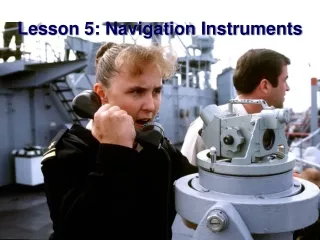

Navigation Instruments: Measurement of Depth, Direction, Distance, and Speed
E N D
Presentation Transcript
Lesson 5: Navigation Instruments • AGENDA: • Measurement of Depth • Measurement of Direction • Measurement of Distance • Measurement of Speed • Applicable reading: Hobbs pg. 110-128.
Measurement of Depth • Echo Sounder (fathometer) • Hand leadline
Lead Line • Manual method of determining depth • Also allows for a sampling of the bottom type
Measurement of Direction • Bearing: the horizontal direction of one terrestrial point as measured from another, expressed as an angle from 0 to 360 degrees. • There are three references for bearings: • Relative • Magnetic • True
000T / 270R 270T / 180R 090T / 000R 180T / 090R
Measurement of Direction Visual Bearings can be measured in: - Degrees Relative ( # # # 0R ) - Degrees Magnetic ( # # # pstgc OR 0M ) - Degrees True ( # # # 0T) The navigator must convert any of these types of bearings to True before they can be plotted on the chart.
Bearing Circle/Alidade • Azimuth or Bearing Circle • Telescopic Alidade
Bearing Circle • Telescopic Alidade
Measurement of Distance Radar-Distance is obtained by a radio wave that is transmitted into the air and returns as an echo. The time interval between transmission and return can be converted into a physical range. Used for distance (range) only!! Not normally used for bearings
Measurement of Distance STADIMETER Used to determine precise ranges between ships in formation
Making an Observation with the Stadimeter • Distance is determined by: • distance = height of object / tan (angle)
Plotting Instruments Parallel Ruler
Plotting Instruments Parallel Plotter
Plotting Instruments Parallel Motion Protractor
Plotting Instruments • Compass • Dividers
Plotting Instruments Nautical Slide Rule
Operation of Nautical slide Rule • Given two of the following, find the third: • Speed • Distance • Time
Measurement of Speed • Speed over Ground (SOG) = true speed • Speed through the water SPEED THROUGH WATER • Impeller Log • Pitotmeter Log • Doppler Speed Log • Shaft RPM SPEED OVER GROUND • Direct output of many electronic navigation systems (GPS, Loran)
Measurement of Speed Impeller Log
Measurement of Speed Pitometer (Pit) Log
Measurement of Speed Doppler Speed Log
3 Minute Rule • The Distance in yards that a ship travels in 3 minutes (D) is equal to the Ship’s Speed (Spd) in knots multiplied by 100. D = Spd x 100
SPD 10 D = 6 Minute Rule • The Distance in nautical miles that a ship travels in 6 minutes (D) is equal to the Ship’s Speed (Spd) in knots divided by 10.
REVIEW • What does a fathometer measure? • What does D=Speed x 100 tell you?