Comprehensive GIS Data Management and Mapping Services for County Operations
20 likes | 148 Vues
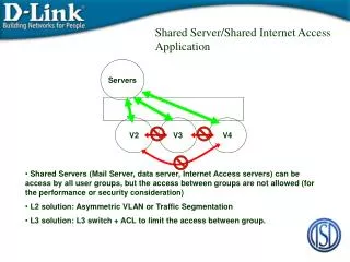
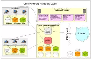
This initiative provides a robust GIS database server utilizing Arc/Info 8.x and ArcView 8.x technologies. The countywide GIS repository offers access to a variety of public and private datasets, including census demographics, administrative boundaries, and essential mapping services. Users can leverage web applications for geocoding, routing, and accessing metadata. Internal departments will benefit from enhanced data access and exploration tools, improving decision-making processes. Security measures, including a firewall and internet security, ensure safe data handling.

Comprehensive GIS Data Management and Mapping Services for County Operations
E N D
Presentation Transcript
Department 1 Department 1 GIS Database Server Arc/Info 8.x Arc/Info 8.x ArcView 8.x ArcView 8.x ArcExplorer ArcExplorer Parks Telecom Other Dept. Department 2 Internal Dept. Data Private GIS Data Private GIS Data County GIS Data County GIS Data County GIS Data Public GIS Data Public GIS Data Public GIS Data Department 2 GIS Database Server Legend Countywide GIS Repository Layout County GIS Mapping Servers (2 internet and 1 intranet) Metadata Explorer (access to county Wide GIS Data Descriptions) • Data Access • Thomas Brothers • Census demographics • Administrative Boundaries • others • Web Services • Mapping • Geocoding • Routing • Searching • Web Applications • Safe Haven • CDC EZ Locator • Driving Directions • Geocoding County Shared GIS Database Server (1 server and 1 SAN) Internet Security Database ISD Firewall Metadata Database Assessor Thomas Brothers Census Mark Greninger (213) 974-5735 LA County CAO/SIB/Urban Research May 14, 2003