Application to Heavy Rainfall
Application to Heavy Rainfall. 9 th THORPEX GIFS-TIGGE Working Group meeting Geneva, WMO Headquarters 31 August – 2 September, 2011. 経田 正幸 KYOUDA Masayuki Numerical Prediction Division, Japan Meteorological Agency. Contents. Information for severe weather preparation at JMA


Application to Heavy Rainfall
E N D
Presentation Transcript
Application to Heavy Rainfall 9th THORPEX GIFS-TIGGE Working Group meeting Geneva, WMO Headquarters 31 August – 2 September, 2011 経田 正幸 KYOUDA Masayuki Numerical Prediction Division, Japan Meteorological Agency
Contents • Information for severe weather preparation at JMA • Early warning information • EPS product • TC-related heavy rainfall • Case study – Typhoon Fitow (T0709) • Model output and its calibration • Calibrated precipitation • Calibration method • Conclusion and suggestion 2
Information for Severe Weather Preparation • Warning, advisory and bulletin services for severe weather • If hazardous weather conditions are expected, JMA delivers a variety of plain messages including warnings, advisories and bulletins to the general public and disaster prevention authorities so that appropriate measures can be taken to mitigate possible hazards. • Bulletins provide information to supplement warnings and advisories. • Early warning information • Five-day track forecast in Typhoon bulletins http://www.jma.go.jp/en/typh/typh5.html • Storm, heavy rain, and high waves for the next few days in bulletin services • Extreme weather as a kind of seasonal forecast Issued every Tuesday and Friday when a high probability (30% or more) of very high or very low seven-day averaged temperature is predicted in the week starting from five to eight days ahead of the date of announcement http://www.jma.go.jp/en/soukei/ 4
EPS product for early warning information • Guidance for early warning information • Currently based on JMA EPS • It is important to update on schedule. • Our own EPS product is easy to work especially for operational use. • Limited use of Multi-center/TIGGE products • Others’ EPS/NWPS outputs are used for reference. • Multi-center’s and ECMWF-EPS’s track are used in TC warning process. • Ensemble TC tracks are available at the Numerical Typhoon Prediction Web site operated by RSMC Tokyo – Typhoon Center in JMA. • EPS plan in the near future and the next • Expected in step with forecast operation’s plan • To increase the resolution of the both EPSs’ model from TL319L60 to TL479L100 • To conduct One-week EPS from once a day to twice a day although the forecast ensemble size is reduced by about half • To increase the ensemble size of Typhoon EPS from 11 to 25 • To extend the forecast range of One-week EPS up to two weeks • To introduce “Reforecasting” 5
JMA Numerical Typhoon Prediction Web site- for the NMHSs of ESCAP/WMO Typhoon Committee Members - • Ensemble TC tracks are available on the Numerical Typhoon Prediction Web site. • Multi-center TC tracks • TC tracks derived from Typhoon EPS
Update cycle, now and in the future 6-hourly update products up to 132 hours ahead Plan to increase the ensemble size up to 25 12UTC 18UTC 00UTC 06UTC 12UTC Daily update products up to 9 days ahead Plan to conduct the EPS twice a day although the ensemble size is cut New and timely EPS products are now available in TC warning process.
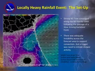
Case study - Typhoon Fitow (T0709) Typhoon Fitow made landfall in Honshu, the main island of Japan, at about 15UTC on 6th September. Weather Chart : at 00 UTC on 6th September Black solid line : Observed track 9
Heavy rainfall associated with Typhoon Fitow 烏川 入間川 荒川 多摩川 相模川 Redand blue lines represent to issue flood warning and no warning, respectively. 3-day accumulated precipitation 683mm 651mm The 3-day accumulated rainfall in mountain region located in the western part of Tokyo exceeded 500 mm and the water level of the Tama River running through Tokyo Metropolitan area exceeded dangerous level. 690mm 10
Typhoon track forecasts of Typhoon Fitow before recurvature The landfall probability on Japan depended on the timing of recurvature. Ensemble forecast up to 9 days ahead 3-Day Track Forecast in Typhoon Bulletins at 00UTC on 3 September 6日09時予報円 9月1日09時 2日09時 5日09時予報円 3日09時 4日09時予報円 Initial time is 12UTC 2 September. 11
Plume diagram for an upriver district Initial time is 12UTC 2 September. In order to explore the use of medium-range NWP output to TC forecasting, it is essential to have an accurate grasp of forecast uncertainties of high-impact weather events controlled by the Typhoon motion, especially whether or not Typhoon will approach. 12
Worst-case scenario (1) Initial time is 12UTC 2 September. Representative track up to 6 days ahead Western track with landfall 13
Worst-case scenario (2) Initial time is 12UTC 3 September. Representative track up to 5 days ahead Western track with landfall 14
Model output and its calibration • Operational global EPS/NWP model • Not easy to predict precious amounts or even the order of strong rainfalls • Underestimation of orographic rainfall (ex. Fitow) • Statistical post-processing • employed routinely to reduce the systematic errors of JMA NWP model • Calibration is essential to detect whether the forecasted rainfall amount exceeds warning level or not, although the observed data are limited. 16
Typhoon Ma-on bringing heavy rainfall Ensemble TC track up to 4 days ahead One-day rainfall amount Based on rain gauge data during19th July 2011 Initial time is 12UTC 18 July 2011. In Umaji Village of Kochi Prefecture, 851.5 mm of rainfall fell on 19th July (local time), ranking high in Japan’s one-day precipitation. The analyzed TC central pressure was 980 hPa and an analyzed maximum wind speed near TC center was 80 kt. 17
Calibrated precipitation Raw data (control run of EPS) Calibrated data Three-hour accumulated rainfall from 21UTC 18th July 2011 Underestimation of antecedent rainfall amount over the mountain regions was calibrated due to orographic effect. Observed gridded data used in the calibration 18
Calibration method • Kalman filter • The predictand is “Radar/Raingauge-Analyzed Precipitation” data which are covered with the Japanese Islands and its surrounding sea area. • The KF output has a tendency of lower frequency of forecasting severe weather events, • such as heavy rainfall, than the • actual. • Frequency bias correction • The scheme is applied to compensate the frequency bias of the KF output. Frequency bias correction forcing Blue : EPS model output Red : Rain gauge Cumulative frequency distribution of 7-day accumulated precipitation at Tokyo for July 2002 to June 2003 19
Conclusion and suggestion • JMA makes some guidance based on its own operational EPS in the early warning operation. • The use and development of Multi-center/TIGGE products are limited, but Multi-center’s track are used in TC warning process. • Heavy rainfall forecasting associated with TC is strongly depend on the uncertainty of the TC motion. • Statistical post-processing is useful to reduce the systematic errors in the operational global EPS model to heavy rainfall. • To exchange gridded data for ensemble precipitation is expected in the TIGGE-FDP activity. • The rule of its exchange should be clear. 20