Download
1 / 17
230 likes | 629 Vues
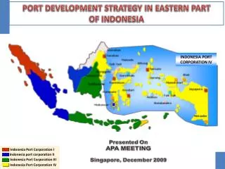
Indonesia Port Corporation I. Indonesia port corporation II. Indonesia Port Corporation III. Indonesia Port Corporation IV. PORT DEVELOPMENT STRATEGY IN EASTERN PART OF INDONESIA. INDONESIA PORT CORPORATION IV. I. INTRODUCTION. Indonesia as a Maritime Country Geographic Condition :

E N D
Indonesia Port Corporation I Indonesia port corporation II Indonesia Port Corporation III Indonesia Port Corporation IV PORT DEVELOPMENT STRATEGY IN EASTERN PART OF INDONESIA INDONESIA PORT CORPORATION IV
I. INTRODUCTION • Indonesia as a Maritime Country • Geographic Condition : • 5,8 million km2 as sea area (75%) • 1,8 million km2 as land area (25%) • Coastal length 95,000 km (14% of World Coastal length) • One of Geopolitical policy as an archipelagic state is Maritime Country • As an Economical Vision for development, one of maritime strategic is directed on the sector : • A synergic maritime spatial arrangement • Transportation Strengthening and seaborne communication (port development and shipping line industry) 1
Number of Port Number of Province Total Container 2 • Characteristics of Western and Eastern Part of Indonesia
II. NATIONAL PORT FRAMEWORK PORT IN INDONESIA SEA PORTS + 1700 PORTS (incl. SPECIAL TERMINAL) RIVER & FERRY PORTS 200 PORTS SPECIAL TERMINAL PRIVATE PURPOSE TERMINAL NON COMMERCIAL PORT MANAGED BY GOVERNMENT COMMERCIAL PORTS INDONESIA PORT CORPORATION I INDONESIA PORT CORPORATION II INDONESIA PORT CORPORATION III INDONESIA PORT CORPORATION IV PUBLIC TERMINAL National Port Framework declared as the government policy, which implementation depends on market mechanism 1. Scope and Type of Port in Indonesia 4
3 2. Direction of development of Port in Eastern Indonesia • Accelerating economic growth • Supporting development of industry and natural resources management • Inter and intra regional system transportation development • To create a liable international port as one of Indonesian gate way Hierarchy of Port in Indonesia
III. FUTURE PORT BUSINESS DEVELOPMENT • Specialized Services As Terminal Operator • Container Terminal • Bulk Terminal • Multipurpose Terminal • Passenger Terminal • Penetration Of Port Services To Special Terminal (Existing/New) Via Strategic Partnership With Special Industry (As The Special Terminal Operator) 3. J/V Company Establishment With Potential Partner • International Port Service Network • Port Engineering • Marine Service 5
IV. SOURCE AND STRATEGY OF FUND 6 • Source of Fund for Port Development : • Internal Corporate Investment : + 30% • Loan (overseas and domestic) : - • Government Investment : + 25% (via Government Capital Sharing) • Private Sector Participation : + 40% • Strategy on Investment Funding
V. SPECIAL CASE OF STRATEGIC PORT IN EASTERN INDONESIA MAKASSAR Port Development • LOCATED IN SOUTHERN PART OF SULAWESI, AND IS IN THE CENTERPOINT OF INDONESIA. • FACE TO MAKASSAR STRAIT (ONE OF THE INTERNATIONAL ROUTE FOR INDONESIAN SEA LANE). • THE BIGGEST EXISTING PORT IN EASTERN INDONESIA. IN NUMBER OF FACILITIES AND TOTAL CARGO THROUGHPUT • MAKASSAR PORT IS PREPARED TO • BE A GATE OF EASTERN INDONESIA Tolitoli Bitung Gorontalo Pantoloan Parepare Kendari Makassar 7
ACCESSIBILITY TO MAKASSAR PORT A) SHIPPING CHANNEL CONDITION • DEPTH OF CHANNEL = 11 - 16 MLWS • WIDTH OF CHANNEL = 150 M • LENGTH OF CHANNEL = 2 MIL • B) LAND ACCESS AND BACK UP AREA • DIRECTLY BORDERED TO DOWNTOWN • INLAND BACK-UP AREA IS UNAVAILABLE FOR PORT DEVELOPMENT C) MAIN FACILITY EXISTING D) TRAFFIC EXISTING AND FORECASTING. 8
1,200,000 Teus TRAFFIK (TEUS) 1,200,000 1.000,000 TERMINAL CAPACITY 900,000 800,000 700,000 600,000 500,000 400,000 300,000 200,000 100,000 TAHUN 2006 2007 2008 2009 2010 2011 2012 2013 2014 2015 2016 2017 2018 2019 EXISTING CAPACITY (600,000 Teus) EXISTING + NEW TERMINAL CAPACITY (1,200,000 Teus) CONTAINER TRAFFIC PROJECTION (2010 – 2020)
10 2. MASTER PLAN OF MAKASSAR PORT • USE 250 HA OF RECLAIMED AREA IN NORTH MAKASSAR, INTEGRATED WITH COMMERCIAL ZONE. • MAKASSAR NEW TERMINAL IS USED FOR PORT SERVICE ACTIVITIES : CONTAINER TERMINAL BULK TERMINAL PASSENGR TERMINAL EXISTING FACILITY (+ 28 Ha) WILL BE DEDICATED FOR DOMESTIC CONTAINER SERVICE AND MULTI PURPOSE SERVICES. C) DEVELOPED THROUGH A SYNERGIC COOPERATION BETWEEN GOVERNMENT OF MAKASSAR CITY AND PT. PELINDO IV.
COOPERATION SCHEME IPC IV MKS CITY JOINT AGREEMENT X EXECUTINGAGENCY INVESTOR A RECLAMATION 250 HA PORT AREA 30 Ha PUBLIC UTILITY 20 Ha BUSSINESS AREA 200 Ha DEVELOPMENT AND CONSTRUCTION DEVELOPMENT AND CONSTRUCTION DEVELOPMENT AND CONSTRUCTION INVESTOR OPERATE CITY GOVERNMENT OF MAKASSAR IPC IV / INVESTOR PROFIT SHARING 11
DEVELOPMENT SCENARIO OF MAKASSAR NEW TERMINAL PHASE I (STARTED 2011) 13 TOTAL INVESTMENT (PHASE I) : US$ 200 MILLION
VI. CONCLUSION 14 1. TO ANTICIPATE THE GROWING OF PORT TRAFFIC, ESPECIALLY IN EASTERN INDONESIA, THE STRATEGY OF PORT DEVELOPMENT WILL BE CARRIED OUT BY STRATEGIC COOPERATION AMONG PT PELINDO IV – LOCAL GOVERNMENT AND POTENTIAL STRATEGIC PARTNER 2. ADDED VALUE FROM DEVELOPMENT OF NEW TERMINAL OF BALIKPAPAN AND MAKASSAR PORT : • IMPROVEMENT IN CONTAINER HANDLING PRODUCTIVITY AND CAPACITY, BY PROVIDING PROPER FACILITIES. • TO ANTICIPATE THE ROLE OF MAKASSAR PORT AS A GATE OF EASTERN INDONESIA.
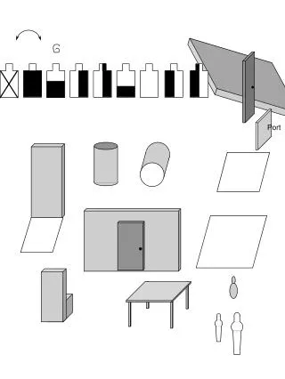
Port Master Planning • Port Master Planning • Short – Middle Term : 5 – 15 years • Long Term : 15 – 25 years • Review for every 5 years • Scope of Planning • Land area Zoning • Water area Zoning