Sea Floor Spreading
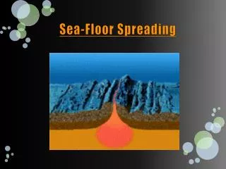
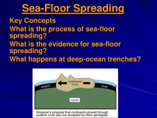
Sea Floor Spreading. Describe the Diagram. Sea Floor Spreading. A process in which new ocean floor is created as molten material from the earth's mantle rises in margins between plates or ridges and spreads out . Discovery.

Sea Floor Spreading
E N D
Presentation Transcript
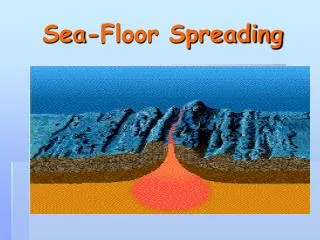
Sea Floor Spreading A process in which new ocean floor is created as molten material from the earth's mantle rises in margins between plates or ridges and spreads out.
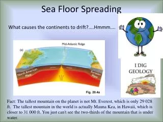
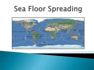
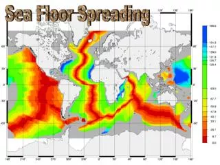
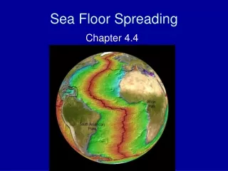
Discovery • The Earth's longest mountain chain isn't the Andes in South America, or the Himalayas in Asia, or even North America's Rockies. It's an underwater chain of mountains 47,000 miles long. The chain runs down the middle of the Atlantic Ocean (surfacing at Iceland), around Africa, through the Indian Ocean, between Australia and Antarctica, and north through the Pacific Ocean
Running along the top of this chain of mountains is a deep crack, called a rift valley. It is here that new ocean floor is continuously created • As the two sides of the mountain move away from each other, magma wells up from the Earth's interior. It then solidifies into rock as it is cooled by the sea, creating new ocean floor • The speed at which new ocean floor is created varies from one location on the ocean ridge to another. Between North America and Europe, the rate is about 2.2 inches (3.6 cm) per year. At the East Pacific rise, which is pushing a plate into the west coast of South America, the rate is 12.6 inches (32.2 cm) per year
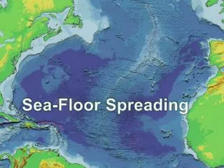
Mapping the Mid-Ocean Ridge The East Pacific Rise is just one part of the mid-ocean ridge, the longest chain of moutains in the world. ~ In the mid-1900’s scientists mapped the mid-ocean ridge using sonar. ~ Sonar is a device that bounces sound wave s off the under water objects and then records the echoes of these sound waves. The time it take for the echo to arrive indicates the distance to the object.
~ the mid-ocean ridge curves like the same of a baseball along the sea floor, extending into all the Earth’s oceans. ~ Most of this mountain lies under 100’s of meters of water but there are a few part that rise above the water level. Iceland is part of the Mid-ocean ridge. ~ A steep sided valley splits the top o the mid ocean ridge for most of its length. It is twice as deep as the Grand Canyon.
Theory is Born ~ Harry Hess: American Geologist studied the mid ocean ridge. he examined maps much like Wegener did. 1960 proposed that the ocean floors move like a conveyor belt carrying the continents with it. • Movement begins at the mid-ocean ridge. Mid-ocean ridge forms along a crack in the oceanic crust. At the mid-oceanic ridge, molten material rises from the mantle and erupts. The molten material then spreads out, pushing older rock to both sides of the ridge. As the molten material cools, it forms a strip of solid rock in the center of the ridge. Then more molten material flows into the crack. This mateiral splits apart the strip of solid rock that formed before, pushing it aside. Hess realized that he sea floor spreads apart along both sides of the mid-ocean ridge as new curst is added.
Evidence Molten Material Scientist dived to the ocean floor in a small sub. In the central valley pillow shaped rocks or toothpaste looking rocks were found. This formation only occurs when molten rock cools quickly. This proves that molten rock is erupting again and again.
Evidence Magnetic Strips • Scientists studied the patterns in the rock. • The rocks of the ocean floor lie in a pattern of magnetized strips. • The stripes hold a record of reversals in Earth’s magnetic field. • Molten rock contains iron. When the molten rock reaches the surface it aligns itself with direction of the magnetic poles. • Once this is hardens iron pieces are locked in place.
Evidence Drilling sample • Actual rock samples drilled from the ocean floor. • Drilling down 6 Km into the ocean floor equal to digging a hole into a sidewalk from the top of the empire state building. • Scientists calculated the age of the rocks. • They found that the farther away from the mid-ocean ridge the rocks were older, the closer they were the younger they were.
Continental crust Oceanic crust