Sea Floor Spreading
What causes the continents to drift?....Hmmm…. Sea Floor Spreading.

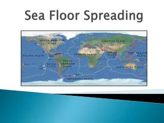
Sea Floor Spreading
E N D
Presentation Transcript
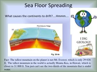
What causes the continents to drift?....Hmmm…. Sea Floor Spreading Fact: The tallest mountain on the planet is not Mt. Everest, which is only 29 028 ft. The tallest mountain in the world is actually Mauna Kea, in Hawaii, which is closer to 31 000 ft. You just can't see the two-thirds of the mountain that is under water.
Beginning just after Wegener’s end, Arthur Holmes began to describe mantle heat flow in terms of convection. Materials that can flow tend to lose thermal energy by the convection process. This explains circulation in a pot of water that is being heated from below in the same way it describes the cooling of the Earth. Mantle Convection Deep materials, hotter than their surroundings (and hence buoyant), would tend to flow upward. In approaching the cool surface of the Earth, the material would lose its thermal energy, cool and sink, having lost buoyancy.
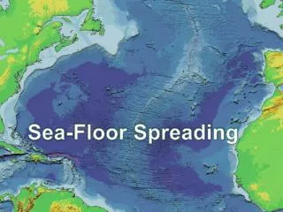
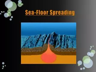
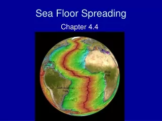
Mid-Ocean Ridge • Mostly under water • Longest chain of mountains in the world • Iceland is where the ridge rises above the water • Sonar- device that scientists use to map the ocean floor *
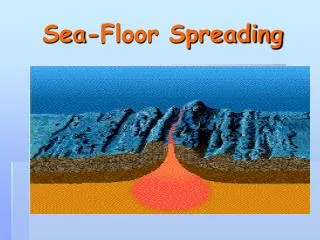
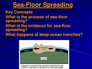
Hess rationalized all of his observations of the ocean floor into a system linked by the old Holmes concept of mantle convection. He conjectured that hot material rose at the oceanic ridges, thus explaining the high heat flow and basaltic volcanic activity, and why the ocean floor is bulged up at the ridges. Harry Hess and Sea Floor Spreading He further thought that where continent and ocean meet, at the trenches, ocean crust is being returned to the mantle at the same rate it is being generated at the ridges.
Hess combined his observations with the earlier ideas of Wegener and the mechanism of Holmes into the concept of sea floor spreading, which lead to plate tectonics. Sea Floor Spreading *This hypothesis makes a number of testable predictions.*
Molten material rises from the mantle and erupts • Molten material spreads out, pushing older rock to both sides of the ridge • New crust is being created *
Evidence for Sea-Floor Spreading 1. Molten Material 2. Magnetic Stripes 3. Drilling Samples *
Evidence: 1. Molten Material • Pillow lava at the Mid-Ocean ridge - pillow lava are rocks that form when molten material cools and hardens quickly in water *
Earth’s Magnetic Field The Earth has an invisible magnetic field. All free-floating magnets at the Earth’s surface point to magnetic north. Iron-rich minerals crystallizing from molten rock will orient towards magnetic north when they cool below the Curie point, the temperature above which permanent magnetism is impossible (580oC for magnetite). Thus lavas lock in the record of Earth’s magnetic field when they form. *
Magnetic Reversals Interestingly, the polarity of the magnetic field shifts every 0.5 - 1.0 Myr. That means rocks formed over time will record either ‘normal’ magnetic orientation (like today), or reversed. Since this is a global phenomenon, these changes can be used for global stratigraphic correlation. * Taking magnetic stratigraphy back in time is paleomagnetism. * *
Magnetic Field: Direction and Inclination Rock magnetism has two components: the direction of magnetic ‘pointing’ and the inclination of this with the Earth’s surface. Magnetic inclination goes from nearly horizontal at the equator to vertical at the magnetic pole. Thus, magnetic records give an indication of where the rock was on the surface when it was magnetized. *
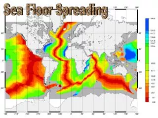
An amazing discovery was made when the magnetic profile of the sea floor around the Mid-Atlantic Ridge was mapped. The maps showed parallel magnetic ‘stripes’ that were perfectly symmetrical across the ridge axis. Paleomagnetism on the Sea Floor Colored stripes are rocks with present-day magnetic orientations (‘normal polarity’), grey represents rocks with reversed polarity. *
Vine and Matthews interpreted the magnetic stripes as products of steady creation of new ocean crust over geologic time, supporting the hypothesis of Hess. Paleomagnetismand Sea Floor Spreading
Past Present 0 1 2 3 4 5
Evidence: 2. Magnetic Stripes(summary) • rock on the ocean floor is in a pattern of magnetic stripes • Stripes show when the magnetic poles on Earth have reversed • Stripes match on each side of the ridge *
Evidence: 3. Drilling Samples drilled samples of ocean floor and dated the rocks • Found rocks near the ridge were youngest and rocks farthest from ridge were oldest *