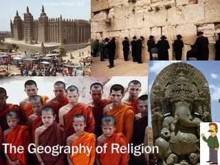
The Tools of Geography
690 likes | 947 Vues
The Tools of Geography. Anywhere Is Possible http://www.youtube.com/watch?v=XRXTGywEFNs. The Geographic Setting. Green slides pages 11-13 brown book. Location. Map Projections – a particular way of showing Earth on a flat map. All map projects have some kind of distortion. . Distortion.

The Tools of Geography
E N D
Presentation Transcript
The Tools of Geography Anywhere Is Possible http://www.youtube.com/watch?v=XRXTGywEFNs
The Geographic Setting Green slides pages 11-13 brown book.
Location Map Projections – a particular way of showing Earth on a flat map. All map projects have some kind of distortion.
Distortion Going from Globe to Map Interactive: http://www.geographyalltheway.com/ks3_geography/maps_atlases/imagesetc/distortion_animations.swf Map Project: http://www.progonos.com/furuti/MapProj/Normal/ProjPoly/Foldout/foldout.html • Distortion– since Earth is a sphere, all flat maps of Earth will have some distortion, for a sphere can never be converted to a flat map perfectly. Distortion is a false representation of distance or area.
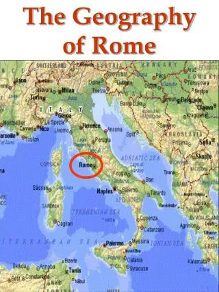
Location Absolute Location – an exact location, can be a street address, email address, or degrees in longitude and latitude. Relative Location – a location expressed in relation to something else, usually includes cardinal or intermediate directions. For example: United States is located south of Canada or the hospital is 3 miles north of Cookout Restaurant.
Map Titles and Symbols Orange slides pages 14 - 15 brown book.
Titles and Symbols Explorer May Symbols: http://www.geographyalltheway.com/ks3_geography/maps_atlases/imagesetc/uk_1250000_symbols.pdf
Titles and Symbols Map Legend (Map Key)– a key to all the symbols used on a map.
Titles and Symbols Direction Interaction: http://www.geographyalltheway.com/ks3_geography/maps_atlases/scale_direction.htm
Is this map upside down? See page 14
Map Titles and Symbols Tan slides pages 16 - 17 brown book.
Longitude and Latitude LatitudeI'm climbing the Ladder of Latitudes, latitudes, latitudes. I'm climbing the ladder of latitudes, all around the world. LongitudeIt's a LONG LONG way from pole to pole, pole to pole, pole to pole. It's a LONG LONG way from pole to pole, so we call those LONGITUDES.
Longitude and Latitude Latitude measures distance in degrees and by North and South from the equator. Longitude (meridians) measures distance in degrees and by East and West from the Prime Meridian .
Longitude and LatitudeLatitude “Parallels” When looking at a map, latitude lines run horizontally. Latitude lines are also known as parallels since they are parallel and are an equal distant from each other. Each degree of latitude is approximately 69 miles (111 km) apart; there is a variation due to the fact that the earth is not a perfect sphere but an oblate ellipsoid (slightly egg-shaped). For example, at 30° N and S, the approximate measure is 60 miles each degree. Zero degrees is the equator, the imaginary line which divides our planet into the northern and southern hemispheres. 90° north is the North Pole and 90° south is the South Pole. Lines of latitude or “parallels”
Longitude and LatitudeLatitude “Parallels” The equator is an imaginary line on Earth’s surface. It is numbered zero degrees latitude (0° latitude). It is approximately equal distant from the North Pole and South pole. It divides the earth into a Northern Hemisphere and a Southern Hemisphere. It is 24,901.55 miles (40,075.16 kilometers) long.
Longitude and LatitudeLongitude Lines of longitude are also called a meridian. Meri – Latin, meaning “middle” Diem – Latin, meaning “day” Meridian once meant “noon” or middle of the day. Therefore, “ante meridian” (A.M.) means time before noon and “post meridian” (P.M.), means time after noon. All points on the same line of longitude experienced noon (and every other hour) at the same time. It was said all these places were on the same “meridian line,” which became “meridian” for short. Longitude lines or "meridians"
Absolute Location a. Arizona (answer: 35 degrees north and 110 degrees west) b. Wisconsin (answer: 45 degrees north and 90 degrees west) c. North Carolina (answer: 35 degrees north and 80 degrees west) d. 45 degrees north, and 70 degrees west (answer: Maine) e. 40 degrees north and 90 degrees west (answer: Illinois) f. 30 degrees north and 100 degrees west (answer: Texas) Answers
Longitude and LatitudePrime Meridian 0° Longitude
Longitude and LatitudePrime Meridian The Prime Meridian and the opposite International Date Line (at 180° longitude), divides the Earth into the Eastern and Western Hemispheres. http://www.greenwich-guide.org.uk/meridian.htm
Longitude and LatitudeLongitude Longitude The vertical longitude lines are also known as meridians. They converge at the poles and are widest at the equator (about 69 miles or 111 km apart). Zero degrees longitude is located at Greenwich, England (0°). The degrees continue 180° east and 180° west where they meet and form the International Date Line in the Pacific Ocean. Greenwich, the site of the British Royal Greenwich Observatory, was established as the site of the Prime Meridian by an international conference in 1884.
Longitude and LatitudePrime Meridian With Latitude, the angular distance is measured from the equator. This is a natural place to begin. However, with longitude there is no natural beginning point. One of these lines must be designated as a prime meridian, or as the 0 ° mark, but which one? For many years, each country had its own prime meridian. France used a meridian passing through Paris, while England used a meridian passing through Greenwich, England. Either one worked just as well, as long as you were only communicating with people from the same country. But what happens as technologies improved, and travelers begin interacting with people from many different lands? If each country is using a different prime meridian to mark 0 ° longitude, than it would be impossible to give someone from another country a location, and have them be able to accurately find it.
Longitude and LatitudeETSU Latitude 36.3034397° North and Longitude 82.3690291° East http://itouchmap.com/latlong.html
Longitude and Latitude http://www.kidsknowit.com/educational-songs/play-educational-song.php?song=Longitude%20and%20Latitude
Longitude and LatitudePrime Meridian Interactive Location Game: http://www.kidsgeo.com/geography-games/latitude-longitude-map-game.php
Map Scale Blue-Green slides paged 18-19 brown book.
Scale A model of an A380 at 1:200 scale. An A380
Scale Long Reef Point from a 1:25 000 map A large scale map refers to one which shows greater detail because the representative fraction (e.g. 1/25,000) is a larger fraction than a small scale map which would have an RF of 1/250,000 to 1/7,500,000. Large scale maps will have a RF of 1:50,000 or greater (i.e. 1:10,000). Those between 1:50,000 to 1:250,000 are maps with an intermediate scale. Maps of the world which fit on two 8 1/2 by 11 inch pages are very small scale, about 1 to 100 million. A Long Reef Point taken from a1: 100 000 B
Hemispheres Prefix “hemi-” means “half”
Continents The largest landmasses on Earth are divided into continents.
Oceans Geographer’s also divide Earth’s oceans into areas. Ocean water covers more than 70% of Earth. This ocean is really one big body of water. But geographers usually divide it into four oceans.
Oceans Continents Oceans and Landforms http://hes.ucfsd.org/curricu/mapglobe/landcont.html
Review Interactive Presentation: http://olc.spsd.sk.ca/DE/k9mod/Mapskill/mod3fl5.swf
Map Titles and Symbols Purple slides paged 20-21 brown book.
Earth and the Sun TILT CAUSES SEASONS!!!!!
Climate Zones The three major climate zones on the Earth are the polar, temperate, and tropical zones. Temperatures in these three climate zones are determined by angle of sun’s rays and are marked by latitudes into zones.