Download
1 / 19
190 likes | 210 Vues
Learn about advancements in disaster management systems, geohazards monitoring, and risk assessment to foster utilization of Earth observation data. Discover regional and global approaches for disaster risk reduction. Stay updated on progress and key outputs for the GEO initiative.

E N D
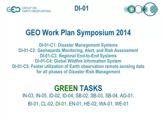
GEO Work Plan Symposium 2014DI-01-C1: Disaster Management SystemsDI-01-C2: Geohazards Monitoring, Alert, and Risk AssessmentDI-01-C3: Regional End-to-End SystemsDI-01-C4: Global Wildfire Information SystemDI-01-C5: Foster utilization of Earth observation remote sensing data for all phases of Disaster Risk ManagementGREEN TASKSIN-03, IN-05, ID-02, ID-04, SB-02, SB-03, SB-04, AG-01, BI-01, CL-02, DI-01, EN-01, HE-02, WA-01, WE-01
Disasters: Development of multi-hazard and/or end-to-end approaches, as appropriate to meet the needs for disaster risk reduction, preparedness and response in relevant hazard environments. More timely dissemination of information from globally-coordinated systems for monitoring, predicting, risk assessment, early warning, mitigating, and responding to hazards at local, national, regional, and global levels. Increased communication and coordination between national, regional and global communities in support of disaster risk reduction, including clarification of roles and responsibilities and improved resources management. Improved national response to natural and man-made disasters through delivery of space-based data, resulting from strengthened International Charter on Space and Major Disasters. Improved use of observations and related information to inform policies, decisions and actions associated with disaster preparedness and mitigation. Support to the successful implementation of the Hyogo Framework for Action 2005-2015.
Key 2014 Outputs – Overview for GEO • Progress has been made across all sub-tasks for D1-01 (reported on here albeit briefly). • Following the CEOS-SIT(29) the disasters work within CEOS supporting GEO targets has been modified (improved) further enabling support for broad GEO goals. • CEOS Disaster activities look toward GEO for further leveraging the work of the space agencies and seeks additional partners in these endeavors.
Status - Update since 2014 Plenary action 27.11 action 27.18 action 27.9 action 27.10 All activities presented at 2013 Plenary progressing according to schedule (Approved by SIT) • DRM Pilots: Agencies’ responses to EO requirements from 3 Pilots (floods, seismic hazards, volcanoes) received and assessed; Strategic EO Acquisition Plan developed. • Supporting activities e.g. flood monitoring and supersites on-going • Supersites: evaluation of new candidates completed. Selection process being improved. • Recovery Observatory: proposal consolidated • 2015 WCDRR+HFA2: several key contacts established, key strategic messages prepared, CEOS Voluntary Commitment drafted, participation (and contribution) in key preparatory meetings in 2014 carefully prepared.
Status - Update since 2013 Plenary action 27.12 • 3 CEOS Agencies just joined WGDisasters following call from CEOS Chair: Australia, South Africa and China • “Structure of WGDisasters” prepared by ad hoc team (CNES, CSA, DLR, ESA, JAXA, NASA, NOAA and USGS incl. CEO and SEO) • team members selected for their key role in disaster-related activities in 2013.
Several Disaster Teams before 2014… CEOS teams involved in disaster-related activities …. • DRM team incl. 3 Thematic Teams (floods, seismic risks, volcanoes) + Recovery Observatory Oversight Team + 2015 WCDRR Task Team • Supersites Coordination Team • Disaster SBA Team (support to GEO Disaster activities. Includes coordination of GEO-related activities of other teams) • WGISS GA4D team (WGISS Architecture for Disaster) • Disaster Study Group (temporary mandate to reorganize CEOS Disaster activities) • CEOS WGs, VCs, SEO with disaster-related activity: e.g. WGCapD for Capacity Building activities, ACC for Volcanic Ash Monitoring, ..
“Vertical” & “Horizontal” Teams FLOODS Thematic Team SEISMIC RISKS Thematic Team VOLCANOES Thematic Team Recovery Observatory Oversight Team 2015 WCDRR – HFA2 Team Supersites Coordination Team Disaster SBA Team WGISS GA4D Team SEO WGCapD
WG Internal Organisation: Teams & Functions ESA NASA outgoing WGDisasters Experts WG Chair (single person with secretarial support) Liaison to GEO Disaster SBA (single person) WG Vice-Chair (single person) Liaison to User Communities (one or two persons) CSA tbd … … … … … … NASA & NOAA ESA & DLR USGS & ASI FLOODS Thematic Team (2 co-leads + experts) SEISMIC RISKS Thematic Team (2 co-leads + experts) VOLCANOES Thematic Team (2 co-leads + experts) CNES Recovery Observatory Team (1 Lead + experts) 2015 WCDRR – HFA2 Team (1 Chair + experts) JAXA Data Coordination Team (1 Chair + 1 Representative per Space Agency . Includes the former Supersite Coordination Team ) tbd
SS & NL Background • The GEO Geohazards Supersites Initiative • Aims at enriching our knowledge about geohazards by empowering the global scientific community through collaboration of space and in‐situ data providers and cross‐domain sharing of data and knowledge • Primarily through providing easy and free-of-charge access to comprehensive satellite and ground-based geophysical data sets derived from different sources and different disciplines
Accepted Decisions for SIT#29 • Accept Marmara Sea / North Anatolian Fault Zone as Permanent Supersite and commit data resources • Accept Mt. Etna volcano as Permanent Supersite and commit data resources • Accept Mt. Vesuvius / Campi Flegreii as Permanent Supersite and commit data resources • CEOS Principals to accept proposal to streamline CEOS acceptance procedure
Mt. Etna volcano: Contributions/Commitments • SIT accepts the Supersite Proposal and agrees to support it by making available data according to the request in the proposal and up to the limits listed below. • SIT requests that the Supersites Coordination Team inform the PoC for the Supersite of this decision and the procedures of ordering and accessing the data • Indicative data resources committed • CEOS intends to to support this Supersite with these resources: • (ASI) 250 scenes/yr by end 2016 COSMO/Skymed • plus past acquisitions • (CNES) 1 coverage per yearPleyades • (CSA) 30 scenes/yr by end 2016 Radarsat-2 • (DLR) 130 scenes by end 2016 TerraSAR-X • plus past acquisitions • (ESA) complete archive ERS-1, -2, Envisat 110 acquisitions per year Sentinel-1 • any avaliable image Sentinel-2, -3 • (JAXA) 16 scenes/ yr by end 2016 ALOS-2 • tbd ALOS-1, J-ERS • (NASA) 44 images/yr ASTER • 22 images/yr EO-1 (Hyperion)
Recovery Observatory – the need Indonesian Tsunami 2004 Hurricane Katrina 2005 Deepwater Horizon 2009 Haiti Earthquake 2010 Tohoku Tsunami 2011 Photo credits: www.nationalgeographic.com; www.mediamythalert.com; www.tampabay.com; www.manongeo.wordpress.com; www.japansociety.org.uk.
Recovery Observatory – the idea Response (weeks) Recovery (years) • Recovery Observatory (3-5 yrs) • Organise EO data from response phase and pre-disaster in repository • Plan coordinated acquisitions to support: • Built area damage assessment (initial and later detailed); • Natural resource and environment assessment; • Reconstruction planning; • Reconstruction monitoring; and • Change monitoring. International Charter Sentinel-Asia EO data from National Agencies Commercial providers Copernicus/GMES Coordination Effective Resource Allocation Clear Institutional Links Ad Hoc Approach Lack of Coordination and Cooperation Lack of Institutional Links Lack of Awareness of Role of EO
DI-01-C1 – GEOSS Architecture for Disasters • The Architecture document is facilitating interoperability conversations between data providers and disaster response personnel in a variety of international venues such as GEO, CEOS, UN-SPIDER, OGC, AGU and IGARSS, ESIP Fed • Architecture analysis provided an opportunity to identify and prototype key gaps in international disaster architecture, especially the link between global and local data • The prototype developed and validated architectural concepts including • Distributed and virtual Cloud-based functional nodes • Methods to access local data to validate EO processing, including crowdsourcing techniques • The GeoSocial API with social media distribution of products for discovery and sharing NAMIBIA FLOOD DASHBOARD • The architecture analysis spawned several related activities including the contributions to CEOS Disasters Mgmt. activities, USGEO, the OGC Architecture Implementation Pilots and Emergency and Disaster Management DWG, the ESIP Fed Disasters Cluster, SERVIR landslide and flood model enhancements and capacity building in Namibia
GEOSS Architecture for Disasters Data Acquisition Key functional activities incorporating satellite data and value-added services in the disaster management enterprise Remote In situ Archive • Key activity stages • Initiation – identify & evaluate: • Satellite observations • Disaster event triggers • Modeling elements • Workflows, data flows • Automation opportunities • Product validation methods • Situational awareness & response • Detect/predict events • Monitor operations • Task sensors, acquire data • Model and predict impact • Analyze and interpret data • Disseminate disaster products • Recovery & risk assessment • Integrate satellite products with local resources (maps, etc.) • Assess recovery progress • Review historical data • Identify & assess risks • Research science methods to improve prediction, preparedness, response Task sensors Acquire data NAMIBIA FLOOD DASHBOARD Dissemination Analysis Preprocess Visualize Analyze Publish product Interpret Alerts / Notices Ongoing updates Modeling Forecast Nowcast Hindcast Event Detection Routine / Global Monitoring Situational Awareness User-generated postings Gather / Assimilate Information Decision Analysis: Act / Plan Routine / Global model outputs User Access Initiators Actuators Processors Coordinators
WCDRR and Post HFA Expected Outcome of WCDRR A) the post‐2015 framework for disaster risk reduction B) the voluntary commitments of stakeholders C) the political declaration Guiding principles for post HFA, additions from HFA 1. Sustainability of development and resilience 2. Natural and technological hazards 3. International legal obligation and safeguard for prevention and reduction of disaster risk 4. Further cooperative efforts for trans‐boundary and global characteristics of risk drivers 5. Availability of open source and open access science-based risk information and knowledge Ref: Proposed Elements for Consideration in the Post2015 Framework for Disaster Risk Reduction by the UN Special Representative of the Secretary General for Disaster Risk Reduction, UNSIDR 17 Dec 2013
CEOS Main Strategic Messages - Satellite EO and Disaster Risk Management - Main strategic messages for WCDRR/HFA2 has been developed. The messages will be used for lobbying at major meetings. • 5 Key Strategic Messages: 1. Satellite EO data complements other data sources but provides unique information. 2. Satellite data needs to be transformed into a higher-level information that can be more readily applied by end-users. 3. Satellite data contributes on all scales, from global, through regional, to local issues. 4. Space agencies want to cooperate with major stakeholders to identify the most critical users’ needs and to establish a plan for a sustained and coordinated response to those needs. 5. User community representatives have an important role to play in the identification of priorities for space agency attention and must stay engaged throughout implementation and operation of the resulting programmes
WCDRR Summary • WCDRR Task Team (WTT) developed short lists of key people and key meetings, and drafted CEOS main strategic messages and CEOS voluntary commitments. • WCDRR/HFA2 is a long UN process and regional consultations on HFA2 already started. • CEOS needs to lobby through governments and international organizations for the regional platforms and Preparatory Committee meetings. • Side-events and exhibition at key meetings need to be planned to promote understanding on satellite capabilities for DRR.
Intervention needed from GEO Members and POs to Achieve 2015 Strategic Targets • As always CEOS looks to strengthen and leverage disaster efforts across GEO members with the ongoing work of CEOS. • Bringing in the pertinent (disaster) in-situ data would be a extremely useful. • Work on where and how investments in disaster activities can broadened and sustained.