Download
1 / 11
110 likes | 274 Vues
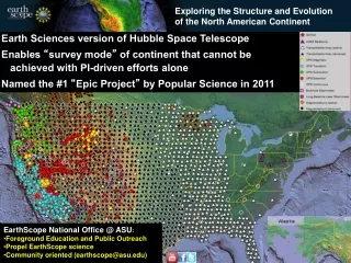
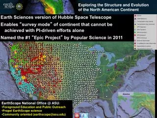
Exploring the Structure and Evolution of the North American Continent. Earth Sciences version of Hubble Space Telescope Enables “ survey mode ” of continent that cannot be achieved with PI-driven efforts alone Named the #1 “ Epic Project ” by Popular Science in 2011.

E N D
Exploring the Structure and Evolution of the North American Continent Earth Sciences version of Hubble Space Telescope Enables “survey mode” of continent that cannot be achieved with PI-driven efforts alone Named the #1 “Epic Project” by Popular Science in 2011 EarthScope National Office @ ASU: • Foreground Education and Public Outreach • Propel EarthScope science • Community oriented (earthscope@asu.edu)
Synoptic perspective Community data and facilities Hierarchical nesting of focused projects within broad coverage Integrative and multidisciplinary www.earthscope.org
Integrated geodetic and seismic facility cooperative agreement planning IRIS and UNAVCO will submit proposals in September 2012 for integrated 2013-2018 Operations and Maintenance including USArray and the Plate Boundary Observatory. The proposals must demonstrate deep community input. Any expansion of purview will come from a fixed level of funding and therefore at the expense of something else important or increased efficiency. UNAVCO/PBO and IRIS/USArray as base infrastructure for expansion and integration. Lay the groundwork now to indicate scientific importance
EarthScope-GeoPrisms Joint planning efforts: Alaska (September 2011) ENAM (October 2011) Cascadia (April 2012) of intersecting research questions
PBO in green and yellow ANSS backbone in purple
Alaska 2013-2018 272 sites 85 km grid
Alignment of EarthScope and GeoPRISMS science objectives Tentative correlation
USArray ground motion visualization Oklahoma earthquake http://www.iris.edu/spud/gmv
Transportable Array • ~1245 stations so far; ~439 to go • ~778 stations removed http://arcserver1.iagt.org/TacoKMZ