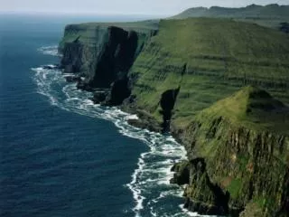
Facts and Figures
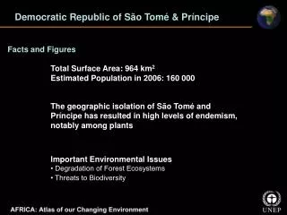
Democratic Republic of São Tomé & Príncipe. Facts and Figures. Total Surface Area: 964 km 2 Estimated Population in 2006: 160 000. The geographic isolation of São Tomé and Príncipe has resulted in high levels of endemism, notably among plants. Important Environmental Issues


Facts and Figures
E N D
Presentation Transcript
Democratic Republic of São Tomé & Príncipe Facts and Figures Total Surface Area: 964 km2 Estimated Population in 2006: 160 000 The geographic isolation of São Tomé and Príncipe has resulted in high levels of endemism, notably among plants Important Environmental Issues • Degradation of Forest Ecosystems • Threats to Biodiversity
Democratic Republic of São Tomé & Príncipe Urban Expansion: São Tomé Island The population of São Tomé increased from a mere 8 431 in 1940 to 51 886 in 2001 The satellite image shows how settlements, especially along roads, have expanded inland from the city
Republic of Senegal Facts and Figures Total Surface Area: 196 722 km2 Estimated Population in 2006: 11 936 000 Senegal is one of the world’s most famous migratory bird sanctuaries Number of threatened plant species in Senegal: 58 Important Environmental Issues • Urban Pollution • Deforestation • Coastal Wetlands and Fisheries Over-exploitation
Republic of Senegal Urbanisation of Cap Vert Peninsula Dakar experienced a large rural-to-urban migration beginning in the 1960s Dakar is concentrated at the southern tip of the peninsula in the aerial photo mosaic from 1942 The 2006/2007 image shows only a portion of the greater Dakar area, which currently stretches another 14 km to the city of Rufisque (not shown)
Republic of Senegal Riverine Forest Degradation: Leboudou Doue In the black and white image, the darker areas of the land enclosed by this great loop on the Senegal River show the extent of the riverine forest in 1966 The 2006 image shows very little of that forest remains
Republic of Seychelles Facts and Figures Total Surface Area: 455 km2 Estimated Population in 2006: 83 000 The smallest country in Africa made up of 115 islands in the Indian Ocean, Seychelles also has the smallest population Important Environmental Issues • Severe Weather and Coastal Erosion • Loss of Mangrove Forests and Protection of Coral Reefs
Republic of Seychelles Land Reclamation: Mahe Island In 1973 land was reclaimed to create a site for the Seychelles International Airport, and in 1986 for a new port facility Two further phases of reclamation were completed in the early 2000s, parts of which can be seen in the 2007 image above (yellow arrows)
Republic of Sierra Leone Facts and Figures Total Surface Area: 71 740 km2 Estimated Population in 2006: 5 679 000 Sierra Leone had the second highest population growth rate in Africa between 2000 and 2005—4.2% per year 90% of the diamonds exported from Sierra Leone are extracted by small scale artisanal miners Important Environmental Issues • Deforestation • Land Degradation • Overfishing
Republic of Sierra Leone Rutile Mining: Moyamba District The Moyamba District, which borders the Atlantic Ocean in the west and Bonthe to the south - is the most active rutile mining area in the country In the 1974 image one small mining operation is visible (centre) - much of the Moyamba District still covered with forests By 2003 mining activities had replaced large portions of forest with water-filled pits
Republic of Sierra Leone Western Area Forest Reserve: Freetown Intense population growth began in Freetown in the 1970s By the mid-1980s the growing city had expanded into the buffer zone and much closer to Reserve borders (1986 image) By 2003, the border of the Reserve had been breached in many places (2003 image) with urban populations encroaching from several directions
Somali Republic Facts and Figures Total Surface Area: 637 657 km2 Estimated Population in 2006: 8 496 000 Northern Somalia is the world’s largest source of myrrh and other incense At 3 330km Somalia has the longest coastline in Africa Important Environmental Issues • Threats to Biodiversity • Desertification, Overgrazing, and Deforestation • Water Scarcity and Drought
A B Somali Republic El Niño Flooding: Juba River Late in the fall of 2006 the Horn of Africa received heavy rains generally believed to have been the consequence of an El Niño weather pattern September 2006 and December 2006 images show a portion of the Juba River before and after the rains respectively A B Flooded areas appear as dark-green to black. Small portions of these images are shown in greater detail
Republic of South Africa Facts and Figures Total Surface Area: 1 221 037 km2 Estimated Population in 2006: 47 594 000 The South African Fynbos, with 8 500 species of vascular plants, is one of the six botanical kingdoms of the world and has a richer flora than any other comparable sized area in Africa Surface area of Lake St Lucia in South Africa — the largest marine lake in Africa is 368 km2 Important Environmental Issues • Water Availability and Quality • Land Degradation • Threats to Biodiversity
Republic of South Africa Indigenous Forests: Amatole Mistbelt South Africa’s Amatole Mistbelt Forests are part of the southernmost areas of Afromontane forest in Africa Comparison of these 1972 and 2001 images shows some new areas of tree cover (yellow arrows) - these are primarily plantation forests of pine and eucalyptus, which threaten to alter the hydrology and reduce the biodiversity of these ecosystems
Republic of South Africa Natural Area Loss in Cape Floristic Region Fynbos covers half of the surface area and accounts for 80% of the plant varieties of the Cape Floristic Region The 1978 image shows large and relatively intact areas of native fynbos vegetation The 2007 image shows how roads, urban development, and agriculture have overtaken much of the area
Republic of Sudan Facts and Figures Total Surface Area: 2 505 813 km2 Estimated Population in 2006: 36 992 000 Sudan is the largest country on the African continent; likewise, its Sudd Wetland—one of the largest tropical wetlands in the world—is Africa’s largest Forest cover lost between 1990 and 2005 was at 11.6% Important Environmental Issues • Soil Erosion and Land Degradation • Poaching and the Ivory Trade • Forests and Fisheries
Republic of Sudan Tree Loss in the Foothills of Jebel Marra The Jebel Marra Massif is a region of high, jagged peaks and fertile valleys in western Sudan The 1972 image shows substantial tree cover across much of the lower left half of the image The 2006 image shows the degree to which vegetation has been reduced, particularly in the less hilly areas and away from croplands concentrated along the watercourses
Republic of Sudan Flooding and the Jonglei Canal: Sudd Swamp The Sudd is a vast wetland ecosystem in southern Sudan where the Nile River meanders for nearly 645 km through the landscape During the dry season (February 2005 image) the wetlands contract to approximately 8 300 km2 of permanent swamp The Jonglei Canal project (yellow arrow) begun in 1978 During the wet season (July/August 2005 image) the Sudd floods expanding to cover 80 000 km2
Kingdom of Swaziland Facts and Figures Total Surface Area: 17 364 km2 Estimated Population in 2006: 1 029 000 Swaziland has 1 400 km2 of forest plantations which cover 8.1% of the country’s total land area 96% of water resources is used for farming in Swaziland Important Environmental Issues • Population Encroachment and Land Degradation • Irrigation and Soil Degradation • Threats to Biodiversity and Invasive Alien Species
Kingdom of Swaziland Sugar Cane Farming: Lubombo Province Sugar cane plantations are found primarily in northeastern Swaziland Sugar cane industry’s water requirements are met by several dams that have been constructed along major rivers These satellite images from 1979 and 2006 show the dams and how the area devoted to sugar cane plantations has increased over time
United Republic of Tanzania Facts and Figures Total Surface Area: 945 087 km2 Estimated Population in 2006: 39 025 000 With large numbers of zebra and gazelle and millions of wildebeest, Serengeti National Park is unequalled for its natural beauty and scientific value Uhuru Point in Mount Kilimanjaro is Africa’s highest point at 5 895 metres Important Environmental Issues • Water Pollution and Aquatic Ecosystems • Land Degradation and Deforestation • Threats to Biodiversity and Ecosystems
United Republic of Tanzania Invasive Plants in Lake Jipe As much of 75% of the Lake Jipe is infested by invasive aquatic plants The bright green areas at the waters edge in the 1975 and 2005 images show these invasive plants covering parts of Lake Jipe Coverage in 2005 is notably more extensive - especially at the northern end of the lake - greyish patch there is evidence that the lake is actually drying up
United Republic of Tanzania Mount Kilimanjaro Glaciers on the summit of Mount Kilimanjaro have decreased in area by 80% since the early 20th century The upper limit of the forest zone has descended significantly, as nearly 15% of Kilimanjaro’s forest cover has been destroyed by fire since 1976 (1976 image shows the upper limit of the Erica excelsa forest is shown in yellow box) By 2000 the upper limit had moved noticeably down slope
Togolese Republic Facts and Figures Total Surface Area: 56 785 km2 Estimated Population in 2006: 6 306 000 Nearly half of Togo’s land is considered arable, making it one of only two countries in Africa with more than 40% of its land suitable for farming 3.5 million metric tonnes of phosphate are produced in Togo annually making it the fifth-largest producerin the world Important Environmental Issues • Land Degradation and Deforestation • Threats to Aquatic Ecosystems • Threats to Biodiversity
Togolese Republic Nangbéto Hydroelectric Dam As demand for electricity grew the decision was made in the 1980s to proceed with the Nangbéto Hydroelectric Dam Satellite images from 1986 and 2001 show the region before and after the dam’s construction Construction of the dam, creation of the reservoir, and installation of transmission lines resulted in the loss of nearly 150 km2 of savannahs and gallery-forests that provided habitat for rare local fauna
Republic of Tunisia Facts and Figures Total Surface Area: 163 610 km2 Estimated Population in 2006: 10 210 000 Tunisia’s Cape Blanc (Ra’s al Abyad) is the northernmost tip of Africa Over 66% of Tunisia is subject to wind erosion with annual transport of sand in a few areas estimated at 50 – 200 metric tonnes per hectare Important Environmental Issues • Land Degradation and Desertification • Water Scarcity • Air and Water Pollution
Republic of Tunisia Changes in Lake Ichkeul Ichkeul National Park includes Lake Ichkeul and surrounding wetlands that form an important wintering and breeding area for migratory birds Lake Ichkeul is fed by seven small rivers but is considered a lagoon because of its connection with the sea via Lake Bizerte (1987 image) Under favorable rainfall conditions the disappearing Potamogeton pectinatus started to recover in 2003 reaching 70 km2 in 2006 (2005 and 2007 images)
Republic of Tunisia Habitat Regeneration: Sidi Toui National Park In 1993, Sidi Toui National Park was established within the bounds of which natural vegetation began to return The 1987 image shows the barren condition of the region before the park was created In the 2006 image the outline of the park - which is protected from the effects of grazing cattle - contrasts markedly with the surrounding landscape
Republic of Uganda Facts and Figures Total Surface Area: 241 038 km2 Estimated Population in 2006: 29 857 000 Uganda is home to over half of the World’s 720 remaining Mountain Gorilla’s(Gorilla beringei beringei) - most of them live in Uganda’s Bwindi Impenetrable National Park 13% of Uganda is covered by wetlands Important Environmental Issues • Land Degradation and Deforestation • Habitat Degradation and Threats to Biodiversity • Water Availability and Pollution
Republic of Uganda Glacial Recession: Rwenzori Mountains A comparison of satellite images from 1987 and 2005 shows a decrease in the extent of glaciers on Speke, Stanley, and Baker peaks The glaciers declined by 50% between 1987 and 2003 A century ago the glaciers of the Rwenzori Mountains covered nearly 6.5 km2 If the glaciers continue to recede as they have since 1906 - researchers estimate they will be gone in the next 20 years
Republic of Uganda Secondary Forest Growth: Mabira Forest A 1989 study estimated that 29% of Mabira Forest was lost between 1973 and 1988 In the 2001 image a large portion of the forest described in 1987 still shows the light green colours of young secondary growth (yellow arrows) The 2006 image shows that this secondary forest still remains largely intact and is maturing
Non-Self-Governing Territory of Western Sahara Facts and Figures Total Surface Area: 266 000 km2 Estimated Population in 2006: 356 000 Western Sahara contains one of world’s richest phosphate deposits. Saharan phosphate is mineral rich and is of great importance for use as fertilizer Western Sahara has the world’s longest belt conveyor system, which is about 100 km Important Environmental Issues • Land Use and Food Production • Water Resources • Marine Fisheries
Non-Self-Governing Territory of Western Sahara Phosphate Mining: Bou Craa Since 1974 the Bou Craa mining operation has been growing steadily The conveyor belt is visible as a straight line from the upper left corner toward the centre of the 1987 and 2007 images The conveyor belt is visible in the 2000 image running from the mine to the coast Note the fringe of drifting sand spreading downward from the belt’s path (yellow arrows)
Republic of Zambia Facts and Figures Total Surface Area: 752 618 km2 Estimated Population in 2006: 11 861 000 Kafue is Zambia’s oldest park and largest park, spreading over 22 400 km2 45% of Zambia’s population live in urban areas Important Environmental Issues • Copper Mining and Water and Air Pollution • Deforestation and Wildlife Depletion • Urbanisation
Republic of Zambia Natural and Managed Flooding: Kafue Flats The Kafue Flats floodplain provides important habitat for rare and endemic species Itezhi-tezhi Dam was built a few years later to provide more storage capacity for electricity generation at the Kafue Gorge Dam The 2007 image shows the Kafue Flats during wet season floods The 1970s image shows Kafue Flats in the dry season with water levels retreating
Republic of Zambia Copper Mines: Copperbelt Province Large-scale copper mining began in north-central Zambia’s Copperbelt Province during the 1930s Large urban centres, open-pit mines, and areas of deforestation are already apparent in the 1972 image. These urban areas continued their rapid growth resulting in the much larger areas of degraded and deforested woodlands visible in the 2006 image
Republic of Zimbabwe Facts and Figures Total Surface Area: 390 757 km2 Estimated Population in 2006: 13 085 000 Zimbabwe’s population of the critically endangered black rhinoceros has grown from 370 in 1993 to around 500 now 45.3% of Zimbabwe is covered by forest Important Environmental Issues • Land Degradation and Deforestation • Water Access and Drought • Wildlife Poaching and the Black Rhinoceros
Republic of Zimbabwe Invasive Plants in Lake Chivero One year after Lake Chivero was created in 1952 water hyacinth made its first appearance By 1989 water hyacinth covered 20% of the lake’s surface (yellow arrows on 1989 image) By 1997 it appeared that water hyacinth had been brought under control (2000 image yellow arrows) By 2005 the invasive plants had returned again reportedly covering as much as 40% of the lake
Republic of Zimbabwe Agriculture Changes: Mashonaland These satellite images show the subdivision of several large commercial farms into smaller farms in a region of Mashonaland Central Province In the August 2001 image, many large farm fields can be seen as large blocks of bright green By August 2005 many of these same farms have been broken into smaller fields (yellow arrows)
Thank You! For more information and free download go to: http://www.na.unep.net/AfricaAtlas/ To purchase go to: http://www.earthprint.com/