Download
1 / 14
200 likes | 1.15k Vues
GIS Applications in Hydrology. Baxter E. Vieux, Ph.D., P.E. School of Civil Engineering and Environmental Science University of Oklahoma 202 West Boyd Street, Room CEC334 Norman, OK 73019 bvieux@ou.edu. Web Pages. Faculty profile

E N D
GIS Applications in Hydrology Baxter E. Vieux, Ph.D., P.E. School of Civil Engineering and Environmental Science University of Oklahoma 202 West Boyd Street, Room CEC334 Norman, OK 73019 bvieux@ou.edu
Web Pages • Faculty profile http://www.coe.ou.edu/research/profiles/cees/vieux/content.html • Environmental Modeling and GIS Laboratory Under construction, but… http://www.coe.ou.edu/emgis/contact.htm • Independent Study Course in Hydrology http://www.occe.ou.edu/isd/ce5843/ • On campus course in Hydrology http://www.ecn.ou.edu/vieux/www/ce5843/index.htm
Geographic Information Systems Geographic information systems (GIS) are a useful tool for analysis of spatially distributed features on and under the earth surface. Considering the inherently spatial character of components of the hydrologic cycle, GIS is increasingly used by hydrologists to analyze, simulate, and understand hydrologic processes. Representation of the essential physical characteristics of a hydrologic process in terms of parameter maps raises issues not generally considered by hydrologists before the advent of the technology and spatial data. Spatial resolution, scale, attribute uncertainty, surface interpolation, error propagation, and aspects related to the linkage or integration of spatially distributed data within a GIS and a hydrologic model. Web links: http://www.ecn.ou.edu/vieux/www/ce5843/resources/index.htm
GIS Data Characteristics of GIS Data— • Map scale, spatial detail, and extent • Coordinate systems • Datums • Map projections • Points, contours, rasters, TINs
Data types • Watershed boundaries delineation • Soil and landuse/cover classification • Digital elevation data • Meteorological parameters • Radar • Satellite
Digital Elevation Model We are here I was there
Projections • Georeferenced coordinate systems • Review of geographic coordinates • Ellipsoidal versus spherical
Stereographic Projection • Parameters— • Spheroid=sphere • Central Meridian=105W • Reference Latitude=60N
HRAP Projection • Parallels of latitude • 0 equator • +90 North pole • Meridians of longitude • 0 Greenwich England • 0-180 Western
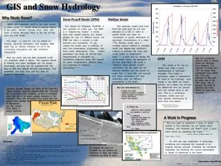
GIS Application to Flood Prediction • Mapping rainfall into a basin • Rainfall intensities in space and time • Rainfall extent versus basin size • Case study: Tulsa, May 5-6, 2000
Basin Hydrology Using GIS Objective— • Use a GIS to estimate rainfall accumulations over a small watershed • Become familiar with GIS concepts involved with • Watershed delineation • Rainfall maps • Fast response basin hydrology
Exercise Items you will need-- • Laboratory handout— tulsa_ex.doc TulsaWorld.htm • Exercise data— tulsa_ex.apr Open the Arcview Project Follow the exercise