Download
1 / 13
130 likes | 247 Vues
Explore San Antonio's water system challenges amid rapid growth, aquifer usage, and drainage issues. Learn about weather patterns, aquifer levels, and population influences.

E N D
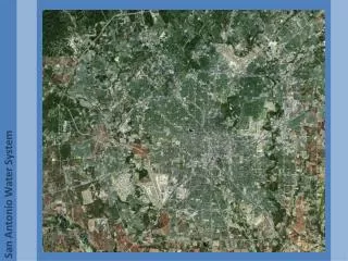
San Antonio has always had a delicate relationship with water. The city is the largest in Bexar county and is both its largest consumer of water, and its largest producer of runoff. Its population of slightly more than 2 million makes it the second largest city in Texas. The Native Americans who lived in the San Antonio River Basin called the area “Yanaguana” or “refreshing waters”. In the last decade the city has become one of the fastest growing areas in the nation. This has begun strain the water systems of the area. Bexar County encompasses a land area of 798,080 acres. 19,015 acres are irrigated. San Antonio Water System: The City
San Antonio River Basin: The basin includes Bexar, Goliad, Karnes, and Wilson Counties. Edwards Aquifer supplies 56% of total water used in the area. South Central Texas Region: Rio Grande Nueces San Antonio Basin Guadalupe Basin Colorado Basin Lavaca River Basin Colorado-Lavaca Basin Lavaca-Guadalupe Basin San Antonio-Nueces Coastal Basin San Antonio River Authority Created May 5, 1937 San Antonio Water System: Drainage
The San Antonio River Basin: San Antonio receives much of its water from underground sources and above ground aquifers. The city does not currently have a water collection program for any excess water from heavy rainfall. This rainfall occurs rarely and often floods the storm water systems. The cities drainage strategy consists of a mixture of underground and above ground storm water channels. These often back up during intense rainfall and flood low lying homes and roads. San Antonio Water System: Major Aquifers
Monthly Precipitation Jan 1.66in. Feb 1.75in. Mar 1.89in. Apr 2.60in. May 4.72in. Jun 4.30in. Jul 2.03in. Aug 2.57in. Sept 3.00in. Oct 3.86in. Nov 2.58in. Dec 1.96in. San Antonio’s climate is classified as humid sub-tropical. The city lies in the center of three climatic division of Texas: the Edwards Plateau, South Central, and Upper Coast. The summers are hot and humid, while the winters are mild and dry. The mean annual precipitation of this area is 30 inches. The vegetation of the area is classified as sub-tropical including: small trees, shrubs, cactus, weeds, and grasses. Trees in the area are often small and shrub like and include: honey mesquite, live oak, and post oak. San Antonio Water System: Climate
The Edwards Aquifer is the main collection point of potable water for the city of San Antonio. The graph to the right shows the water level of the aquifer over the last year.. The city has been in drought for the last several years. Water restrictions have been in place for the last several years limiting primarily the amount of water available for residential landscaping. The city is currently experiencing stage II water restrictions and is quickly moving to the next stage. San Antonio Water System: Edward Aquifer
Rainfall is fairly rare for long periods in San Antonio. The rainfall that does occur often happens in very short periods of time. The drainage systems are a mixture of above and below ground drainage channels. The area is very hilly and intense rains will often overwhelm the system and flood low lying roads and houses. Currently there is no large scale collection effort for storm water. This is an untapped resource that the city is attempting to take advantage of. The city currently has plans to upgrade the storm water systems in several areas. San Antonio Water System: The City
Unemployment Northern area: This area is the most recently developed area of the city. It is extremely pedestrian unfriendly. There have been many new businesses and public works constructed here such as hospitals and banks, making this a very affluent area. Downtown: This area is the most heavily developed and the oldest part of the city. Southern area.: This is also an older area with a high level of manufacturing and commercial enterprises, also very pedestrian unfriendly. San Antonio Water System: Unemployment
Poverty: San Antonio is fairly affluent area with a strong economy. The southern area of the city is traditionally the poorer area of the city and is often considered an unfavorable place to work and live. The northern are of the city is newer and has seen a great deal of recent investment. This area is considered the “up and coming part of the city”. The center of the city is still the main concentration of the high level corporations, hospitals, and banks. This is the stable core of the city. San Antonio Water System: Poverty
Population Density: The central area of the city inside Loop 410 is fairly dense. The true downtown area has a fairly high density and is the most urban part of the city. The areas outside Loop 410 are fairly suburban with lower population densities. The newest areas of development in the north are extremely suburban. San Antonio Water System: Density
Proposition 2 26 Projects funded by bonds worth $152,051,818 These projects are an attempt to shore up the drainage systems of the city so that more areas are prepared for a 100 year flood. Most of the proposed projects are clustered in the northern half of the city. This area of the city is very affluent, but is also the newest region of the city so it may simply be in need of more development. San Antonio Water System: Developement
http://cip.sara-tx.org/website/cip/viewer.htm http://www.saws.org/our_water/aquifer/ http://bexarwatershed.org/images/rivers_tribs_BC_cropped.jpg http://www.sanantonio.gov/planning/GIS/demo_map_catalog.asp http://www.regionltexas.org/ http://www.saws.org/our_water/aquifer/map.html San Antonio Water System: Bibliography