Download
1 / 23
230 likes | 431 Vues
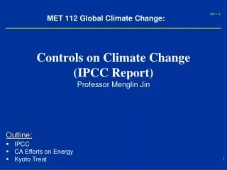
Climate change and Protected Areas: a broad outline of what is known? . Neil Burgess Scientific Advisor. Part I. Background on the region and existing data on climate change, demographics etc. Vegetation zones in West Africa. Sahara desert Sahelian savanna Sudanian savanna Guinea savanna

E N D
Climate change and Protected Areas: a broad outline of what is known? Neil Burgess Scientific Advisor
Part I • Background on the region and existing data on climate change, demographics etc
Vegetation zones in West Africa Sahara desert Sahelian savanna Sudanian savanna Guinea savanna Rainforest Mangroves Vegetation zones move according to climate Sea level rises under climate change
What do the climate change models say? • Quite a variable story of change • Things might get worse • Quite a lot • Or not so much • Or we are not very sure
Demographic change in West Africa 1960 and predicted to 2020
Climate Change impacts – general considerations • West Africa climate change predictions very variable. All agree it will get hotter. • Predictions for rainfall vary from 0% to +40% for Dec-Feb and from -20% to +20% for the June to August season. • Vegetation zones (Sahara, Sahel, Sudanian, Guinea, Forest) will expand north if the climate gets wetter, and contract south if it gets drier • Forest species and protected areas may suffer, especially on northern margins and in Guinea savanna / forest mosaic • People will be moving in the landscape
How will this impact protected areas?And the species that live in them?
CORE + CORE + C T + + T T C + C
Effective management of reserves (Management Effectiveness Tool) Reserves with management effectiveness assessed (2009) In West Africa We know there are more than this
Protected Area data and management effectiveness data are contained within the UNEP-WCMC World Database of Protected Areas – a freely available resource for the world
Climate Change Susceptibility of species - Birds Biological Susceptibility Exposure
Estimating direction of movement due to climate change- birds
Predictions on bird assemblage change in protected across Africa Turnover of species - blue is low Little change predicted in West Africa % change in species
What is the project going to do? 1) Build links between National Government and partners and international expertise: • Climate change agencies (UK Hadley Center) • Science NGOs (IUCN, BirdLife) • Biodiversity impact modeling agencies (Durham University) The project needs to identify the key national / regional experts / agencies
To do the following • Improve knowledge of distribution ranges of species • Improve IUCN red list for species in the region • Improve protected areas data for the region • Model impacts of climate change on species, and protected areas • Build capacity nationally and regionally
Which will involve a lot of Capacity Building, Collaboration and Partnerships Example - Climate Change Vulnerability Traits for species: collaborative workshops
BETTER UNDERSTANDING AND MANAGEMENT OF PROTECTED AREAS IN THE CONTEXT OF CLIMATE CHANGE THE PROJECT • Identification of risks to PAs as a consequence of CC • Planning for adaptive measures to minimise risks • Communication • Knowledge Management • Monitoring and Evaluation Vulnerability to climate change assessments and risk reduction strategies Gap analysis and spatial planning • Training • Pilot corridors and trans-boundary PAs • Policy support Data collection Guidelines on managing PAs Climate modelling Monitoring tool to track future impacts Review of management approaches Connectivity, species and community assessments 18
Part II : Development and Application of Climate Change Adaptation Tools for Protected Areas • Modified “Management Effectiveness Tracking Tool” • Modified “Threat Reduction Tool”
Scoring • The METT tool provides scores for various elements of protected area threats, management, outcomes • The METT tool has been modified to include Climate Change impacts • These scores can be used to assess the effectiveness of management and track changes over time, INCLUDING climate change issues
Threat Reduction Assessment Tool • A score card that aims to rank threats and then assess the degree to which the threat has been reduced by a project intervention • Might be modified to assess the threat posed by climate change and how this has been reduced by interventions