Europe
Europe. Physical Geography. Where is Europe?. Part of Eurasia (or Afro- E urasia) Eastern border is the Ural Mountains down to Caucasus and through the Black Sea The Mediterranean Sea separates Europe from Asia The Atlantic forms the Western boundary

Europe
E N D
Presentation Transcript
Europe Physical Geography
Where is Europe? • Part of Eurasia (or Afro-Eurasia) • Eastern border is the Ural Mountains down to Caucasus and through the Black Sea • The Mediterranean Sea separates Europe from Asia • The Atlantic forms the Western boundary • Greenland and Iceland are considered part of Europe
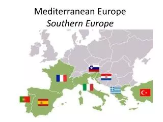
A Peninsula of Peninsulas • Europe is a peninsula of Asia • There are five main peninsulas of Europe: • Jutland • Iberian Peninsula • Apennine (or Italian) Peninsula • Balkan Peninsula • Scandinavian Peninsula • This means that most places in Europe are close to sea access
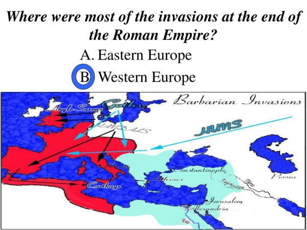
Topography • Southern Europe is mountainous • Continues through hilly uplands • Northern Europe is a broad, flat plain • Good agricultural land • Allowed for invaders
Mountains • Act as a barrier between groups and climate • Major mountains: • Alps • Separate Apennine Peninsula from Europe • Tallest mountain is Mount Blanc • Apennine • Run length of Italian Peninsula • Pyrenees • Separate Iberian Peninsula from Europe • Balkans • Separate Balkan peninsula, breaks up many ethnic groups
Waterways • A strategic waterways • The English Channel • Separates GB from France • The Strait of Gibraltar • Separates Spain from Africa • The Dardanelles and Bosporus • Separates Europe and Asia in Turkey
Climate • Europe is in the middle and high latitudes, therefore, Europe has many different types of climates. • In Northern Europe there are Tundra and Sub-arctic climates. • Most of Western Europe has a Marine West Coast climate zone. • Southern Europe has a Mediterranean climate
More Climate • Wind currents and ocean currents have a large impact on the climate of Europe. • The North Atlantic Drift is an ocean current that warms Europe. • Wind currents called the Westerlies pick up warm air from the NAD and carry it over Europe, they also bring rain • Farther inland, Westerlies have less impact and the climate is more harsh
Human-Environment Interaction The Netherlands and Venice
The Netherlands *Netherlands is also called Holland and the people are known as the Dutch. (I’m fairly sure they did this to create confusion among Geography students) • 40% of the Netherlands was once underwater • Dutch needed more land so they build dikes and created new land: Polders • The Dutch created a freshwater lake by blocking off an arm of the North Sea in the 1900s • Currently there is talk of building a 6500 foot mountain in Holland
Venice • Germanic Tribes were invading Italy, so people fled to a lagoon • Over time became a major trading center • To build Venice • Sunk wooden supports into the lagoon • Venice is gradually sinking due to • Higher sea levels • Sinking supports