Download
1 / 1
10 likes | 176 Vues
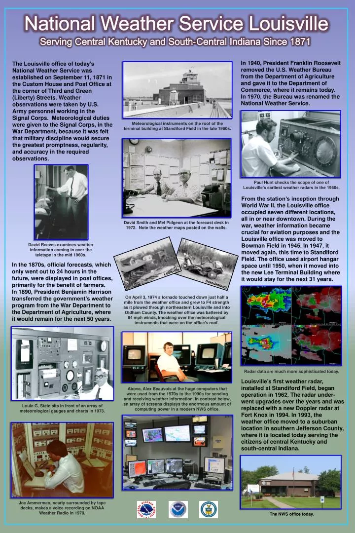
National Weather Service Louisville. Serving Central Kentucky and South-Central Indiana Since 1871.

E N D
National Weather Service Louisville Serving Central Kentucky and South-Central Indiana Since 1871 In 1940, President Franklin Roosevelt removed the U.S. Weather Bureau from the Department of Agriculture and gave it to the Department of Commerce, where it remains today. In 1970, the Bureau was renamed the National Weather Service. The Louisville office of today’s National Weather Service was established on September 11, 1871 in the Custom House and Post Office at the corner of Third and Green (Liberty) Streets. Weather observations were taken by U.S. Army personnel working in the Signal Corps. Meteorological duties were given to the Signal Corps, in the War Department, because it was felt that military discipline would secure the greatest promptness, regularity, and accuracy in the required observations. Meteorological instruments on the roof of the terminal building at Standiford Field in the late 1960s. Paul Hunt checks the scope of one of Louisville’s earliest weather radars in the 1960s. From the station’s inception through World War II, the Louisville office occupied seven different locations, all in or near downtown. During the war, weather information became crucial for aviation purposes and the Louisville office was moved to Bowman Field in 1945. In 1947, it moved again, this time to Standiford Field. The office used airport hangar space until 1950, when it moved into the new Lee Terminal Building where it would stay for the next 31 years. David Smith and Mel Pidgeon at the forecast desk in 1972. Note the weather maps posted on the walls. David Reeves examines weather information coming in over the teletype in the mid 1960s. In the 1870s, official forecasts, which only went out to 24 hours in the future, were displayed in post offices, primarily for the benefit of farmers. In 1890, President Benjamin Harrison transferred the government’s weather program from the War Department to the Department of Agriculture, where it would remain for the next 50 years. Louisville Brandenburg On April 3, 1974 a tornado touched down just half a mile from the weather office and grew to F4 strength as it plowed through northeastern Louisville and into Oldham County. The weather office was battered by 84 mph winds, knocking over the meteorological instruments that were on the office’s roof. , Radar data are much more sophisticated today. Louisville’s first weather radar, installed at Standiford Field, began operation in 1962. The radar under-went upgrades over the years and was replaced with a new Doppler radar at Fort Knox in 1994. In 1993, the weather office moved to a suburban location in southern Jefferson County, where it is located today serving the citizens of central Kentucky and south-central Indiana. Above, Alex Beauvois at the huge computers that were used from the 1970s to the 1990s for sending and receiving weather information. In contrast below, an array of screens displays the enormous amount of computing power in a modern NWS office. Louie G. Stein sits in front of an array of meteorological gauges and charts in 1973. Joe Ammerman, nearly surrounded by tape decks, makes a voice recording on NOAA Weather Radio in 1978. The NWS office today.