Download
1 / 21
210 likes | 386 Vues
Web-based geographic search engine for location-aware search in Singapore. Expert Systems with Applications , 2011 Flora S. Tsai * School of Electrical & Electronic Engineering, Nanyang Technological University, Singapore 639798, Singapore 資工碩一 102598044 劉皓縈. Outline(1). Introduction

E N D
Web-based geographic search engine for location-aware search in Singapore Expert Systems with Applications ,2011 Flora S. Tsai * School of Electrical & Electronic Engineering, Nanyang Technological University, Singapore 639798, Singapore 資工碩一 102598044 劉皓縈
Outline(1) • Introduction • Review of related work • Google erath • Keyhole Markup Language • Street directory • Global Positioning System • Design and algorithms • Database design • Calculation algorithms
Outline(2) • Results and discussion • Simple search • Advanced search • Conclusions and recommendations • References
Introduction(1) • Search engines • designed to help find information stored on a computer system such as on the Web. • location-based search engines • enable the user to search for locations around their area regardless of which part of the world they are from.
Introduction(2) • These systems • map-and-hyperlink architecture, • Web content and geographic information are weaklybonded • Other local search engines • map-and-hyperlink structure • geospatial mapping • navigation of the Web • e.g. • SPIRIT spatial search engine • GeoSphereSearch
Introduction(3) • Web-based local search system • user is able to use their current coordinates as a parameter so that the search engine is able to return results in order of the distance from the user’s current location. • Although the system is currently limited to Singapore-based Web sites, the user is able to view their search locations on a Google Earth satellite map instead of the two-dimensional maps currently used in street directories.
Review of related work(1)-Google earth • Google Earth • a virtual globe program • street map overlays • three-dimensional building models • satellite imagery • aerial photography • Geographical Information System • Keyhole Markup Language (KML)
Review of related work(2)-Keyhole Markup Language • Keyhole Markup Language • A file format • based on the XML standard • display geographic data in an earth browser • e.g. • Google Earth, GoogleMaps, Google Maps for mobile • uses a tag-based structure with nested elements and attributes • place marks • 3D models
Review of related work(3)-Street directory • Streetdirectory.com • An online Web map Service founded by Virtual Map in 2000 • Streetdirectory.com recently tied up withGoogle Earth • able to search for a location • attain longitude and latitude • view the location on a two-dimensional map or a satellite image • attain directions to travel from a specific address to another address • and get a list of amenities or locations around the specified area.
Review of related work(4)-Global Positioning System • Global Positioning System • Developed by the United States Department of Defence • an indispensable aid tonavigation around the world • an important part of map-making and land surveying • The basis of GPS is the mathematical method of “triangulation”fromits position to the satellites • measures the distance using the travel time of radio signals
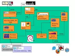
Design and algorithms(1)- Database design • Area, where the keywords of the area are stored, e.g. Causeway Point • General Area, where the General Area of the location is stored, e.g. Yishun. • From the Address, the location is found in Google Earth and a KML file is produced into a folder in the server. • The folder address on the Web server is saved under Folder and the filename is saved under Filename.
Design and algorithms(2)- Calculation algorithms • Two methods for calculating the distance from two coordinates • Vincenty’s Theorem • Haversine’sFormula (faster) • Haversine’sFormula • giving great-circle distances between two points on a sphere by using the decimal degree form of their longitude and latitude coordinates
Design and algorithms(3)- Calculation algorithms • :latitude separation • :longitude separation • R:angle in radians • d:distance d between the two points • h:denote haversin (d/R) - =-
Results and discussion(1) • The database contain 1652 entries with the following categories: Apparel, Bank, Cinema, Department Store, Duty Free Shop, Electronics, F&B (food and beverage), Fast Food, Food Court, Furniture, Health and Beauty, Minimart, Musical Instruments, Restaurant, Snack Bar, Sports, Stationery, Seafood, and Supermarket. • The landmark type searched for are Building, Road, MRT stations, Schools and Shopping Centres.
Conclusions and recommendations(1) • Currently each of the entries are searched using Street Directory and entered into the database manually • A possible upgrade to the Web page is for a Geocoding API to be added to grab the coordinates of the location when the user enters in their addresses • a method of finding out the coordinates through • external program • entering it into the database
Conclusions and recommendations(2) • Additions to the database could be the inclusion • informational links • information on the places themselves inside the KML files • like photos, videos, blog articles or historical articles • Future work • more 3D models could also be created for buildings in areas where there are few models. • mapping revolution in which Web pages are tied togeographical coordinates
References • Chen, Y., Tsai, F. S., & Chan, K. L. (2008). Machine learning techniques for business blog search and mining. Expert Systems with Applications, 35(3), 581–590. • Graupmann, J., & Schenkel, R. (2006). GeoSphereSearch: ContextAware Geographic Web Search. In Proceedings of the 2006 workshop on geographic information retrieval (GIR 2006), Seattle, WA, USA, August 2006. • Jones, C. B., Abdelmoty, A. I., Finch, D., Fu, G., & Vaid, S. (2004). The spirit spatial search engine: Architecture, ontologies and spatial indexing. In Proceedings of the third international conference geographic information science (GIScience 2004), • Adelphi, MD, USA, October 2004. • McCurley, K. S. (2001). Geospatial mapping and navigation of the web. In Proceedings of the 10th international conference on world wide web (WWW 2001), HongKong, China, May 2001. • Sinnott, R. W. (1984). Virtues of the Haversine. Sky and Telescope, 68(2), 159. Tezuka, T., Kurashima, T., & Tanaka, K. (2006). • Toward tighter integration of web search with a geographic information system. In Proceedings of the 15th international conference on world wide web (WWW 2006), Edinburgh, Scotland, May 2006. • Tsai, F. S., Han, W., Xu, J., & Chua, H. C. (2009). Design and development of a mobile peer-to-peer social networking application. Expert Systems with Applications,36(8), 11077–11087.