Geographic Information Infrastructure
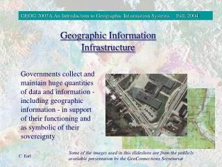
Geographic Information Infrastructure. Governments collect and maintain huge quantities of data and information - including geographic information - in support of their functioning and as symbolic of their sovereignty.

Geographic Information Infrastructure
E N D
Presentation Transcript
Geographic Information Infrastructure Governments collect and maintain huge quantities of data and information - including geographic information - in support of their functioning and as symbolic of their sovereignty Some of the images used in this slideshow are from the publicly available presentation by the GeoConnections Secretariat
There are all kinds of application fields for geographic information: • natural resources management • transportation • agriculture • defense • environmental monitoring • urban planning • recreation • social services
National geographic information (spatial data) strategies are being developed to co-ordinate the collection, dissemination, and use of geographic data. These strategies are called an “Infrastructure”.
When applied to geographic data, infrastructure means the mass of processes, policies, standards, enabling technologies, mechanisms and key datasets required to make geospatial data readily available to the growing community of users. The way these components are organized is different in every jurisdiction. Each geospatial data infrastructure program has its own character.
Canada’s national geoinformation strategy is overseen by GeoConnections. Objectives of national strategies: • promoting economic competitiveness • improving decision-making • providing for better stewardship of the environment and natural resources http://www.geoconnections.org/CGDI.cfm/fuseaction/home.welcome/lang/E/gcs.cfm
GeoConnections is developing the Canadian Geospatial Data Infrastructure (CGDI) for the co-ordination of Canadian databases of geospatial data and their dissemination via the Internet. • The CGDI promotes: • partnerships • reduction in red tape • standards • access • framework data • ----- data alignment layers • ----- land feature/landform layers • ----- conceptual layers
The framework data is designed to enable application development and detailed data collection. • data alignment layers: provide a foundation of reliable geodetic data • land feature/landform layers: provide well-defined natural or man-made features (roads, rivers, e.g.) • conceptual layers: provide the administrative frameworks (municipal boundaries, electoral districts, etc.)
Issues in the creation of national geospatial data strategies: - impact on sovereignty - inequitable access - loss of individual privacy and freedom
Trends in GIS Some of the areas where we see growth and development are in: • the data mountain • integration of GIS with mainstream IT • mobile GIS • interoperability • the Internet • PPGIS
Browser Web server GIS server GIS Application software Geographic database
GIP Program Department of Geography & Environmental Studies Carleton University This program leads to an Honours B.A. or B.Sc. in Geographic Information Processing. The following specialty geomatics courses constitute part of the core but are open to students with other majors providing that they have the appropriate pre-requisites: GEOG 2004: Introduction to Geomatics(Patterson)
GEOG 2007: An Introduction to Geographic Information Systems(Mitchell, Patterson, Earl) GEOG 3002: Air Photo Interpretation and Remote Sensing GEOG 3005: Geospatial Analysis(Patterson) GEOG 3006: Applications of Geographic Information Systems(Patterson) GEOG 3007: Cartographic Theory & Design(Earl) GEOG 4003: Remote Sensing of the Environment(King) GEOG 4006: Analytical & Computer Cartography(Prashker) GEOG 4008: Advanced Topics in Geographic Information Systems(King)