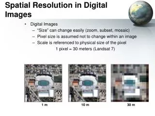
Download
1 / 22
220 likes | 414 Vues
Embedding Digital Images in a File Geodatabase. A Case Study from Cedar Breaks National Monument, Utah. Cynthia Wanschura GIS Technician Elena Robisch GIS Program Manager Zion National Park, Utah. Cedar Breaks National Monument, Utah. The highest point = 10,662 feet

E N D
Embedding Digital Images in a File Geodatabase A Case Study from Cedar Breaks National Monument, Utah Cynthia Wanschura GIS Technician Elena Robisch GIS Program Manager Zion National Park, Utah
Cedar Breaks National Monument, Utah • The highest point = 10,662 feet • Giant amphitheater, spans some three miles and is more than 2,000 feet deep • Due to heavy snowfall the boundary fence is removed each winter Photo from http:\\www.nps.gov\cebr Photo by Lee Rademaker
The Project • Peg Simons, Volunteer In Park: • GPS’ed the fence line • GPS’ed & photo-documented potential problem areas • Integration of digital photos with GPS points
Why did we choose the method of embedding photos in a geodatabase? • No addition software or extensions required, easy sharing • Provided with data, we were not part of the field process • One Image per Point • Option of managing by the geodatabase Photo by Paula Hamilton
Creating the Raster Field Left-click
Managed by the Geodatabase: Sounds Good, Right? • Benefits: • No further need for image management • Automatically moves photos with spatial data • Downsides: • Unstable • Large file size • Always providing photos with the spatial data • Recommendation: Do not have the geodatabase manage the photos.
Alternative Attachment Method Left-click
Left-click on the opens the mini viewer Accessing the Photos through the Table
Accessing the Photos through the Table Left-click on Photo
Accessing the Photos through Identify Left-click
Folder containing photos Table with Photos Feature Class with Spatial Data Linked to Photos Relationship Class Linking Spatial Data with the Photo Table (One-to-Many Relationship) NCP I&M Network Invasive Plants File Geodatabase
Accessing Photos in Related Tables Left-click
Special Thanks • Peg Simons, VIP, Cedar Breaks NM • Nell Blodgett, Formerly GIS Program, Zion NP; Now IMR Geographic Resources • Aneth Wight, GIS Specialist, Northern Colorado Plateau I&M Network Photo by Lee Rademaker
Questions? Comments? Cynthia Wanschura GIS Technician Zion National Park, Utah 435-772-0215 cynthia_wanschura@nps.gov Elena Robisch GIS Program Manager Zion National Park, Utah 435-772-0213 elena_robisch@nps.gov Photo from http:\\www.nps.gov\cebr