Water UndergrounD
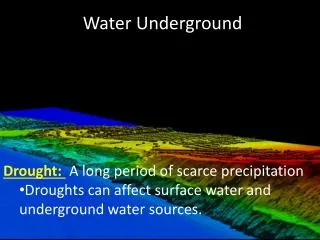
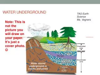
TAG Earth Science Ms. Vegners. Water UndergrounD. Note: This is not the picture you will draw on your paper. It’s just a cover photo. . Homework for this weekend. Study your flash cards!!! Your new flash card set is due on TUESDAY, Oct. 29 th

Water UndergrounD
E N D
Presentation Transcript
TAG Earth Science Ms. Vegners Water UndergrounD Note: This is not the picture you will draw on your paper. It’s just a cover photo.
Homework for this weekend • Study your flash cards!!! • Your new flash card set is due on TUESDAY, Oct. 29th • The test will be on Monday, November 4th(I changed the date- Originally the test was the day after Halloween. Students told me they’d rather have the test on Mon, Nov 4th than Friday, Nov 1st- the day after Halloween.)
Water Underground 11-3 • As you go through this Power Point, answer the questions that were provided to you. Some of the slides will require you to go to other websites for information. • Please use this Power Point to help you study. It is filled with wonderful information! • At the end, there are some additional resources you can look at if you finish your work early.
What You Will Learn Today: • Identify and describe the location of the water table. • Describe an aquifer • Explain the difference between a spring and a well. • Explain how caves and sinkholes form as a result of erosion and deposition.
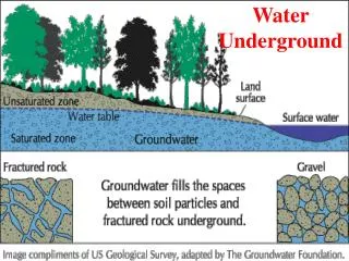
Groundwater Although you can see some of Earth’s water in streams and lakes, you cannot see the large amount of water that flows underground. The water located within the rocks below the Earth’s surface is called groundwater. • Surface water seeps underground into the soil and rock. This underground area is divided into two zones. (Click link below and read.) • http://earth.rice.edu/mtpe/hydro/hydrosphere/topics/water_table.html
Aquifer • A rock layer that stores groundwater and allows the flow of groundwater is called an aquifer.
Porosity • The more open spaces, or pores, between particles in an aquifer, the more water the aquifer can hold. The percentage of open space between individual rock particles in a rock layer is called porosity.
Read this carefully. • If a rock layer contains many particles of different sizes, it is likely that small particles will fill up the different-sized empty spaces between large particles. • Therefore, a rock layer with particles of different sizes has a low percentage of open space between particles and has low porosity. • On the other hand, a rock layer containing same-sized particles has high porosity. This rock layer has high porosity because smaller particles are not present to fill the empty space between particles. So, there is more open space between particles. • See next slide for pictures.
This rock layer has particles of the same size. Lots of pore space. High porosity. This rock layer has particles of different sizes. Less pore space. Low porosity.
Permeability If the pores of a rock layer are connected, groundwater can flow through the rock layer. A rock’s ability to let water pass through is called permeability. A rock that stops the flow of water is called impermeable. Permeability
Animations of Permeability • Click on the link below to see good comparisons of porosity vs. permeability. Stop after the “Permeability” slide. • http://techalive.mtu.edu/meec/module06/SoilClassification.htm
Aquifer Geology and Geography The best aquifers usually form in permeable materials, such as sandstone, limestone, or layers of sand and gravel. Some aquifers cover large underground areas and are an important source of water for cities and agriculture. Click on the link below to see a real time update of the major aquifers of the United States. Notice the largest aquifer area of the US- The Ogallala Aquifer, part of the High Plains Aquifer System, is a vast yet shallow underground aquifer located beneath the Great Plains in the United States. http://groundwaterwatch.usgs.gov/default.asp
Recharge Zones • Like rivers, aquifers depend on the water cycle to maintain a constant flow of water. The ground surface where water enters an aquifer is called the recharge zone. • The size of the recharge zone depends on how permeable the rock is at the surface. If there is an impermeable rock layer, water will not be able to reach the aquifer. (Construction, parking lots, and buildings affect this, too.)
Artesian Springs • A sloping layer of permeable rock sandwiched between two layers of impermeable rock is called an artesian formation. • The permeable rock is an aquifer, and the top layer of impermeable rock is called a cap rock. Artesian formations are the source of water for artesian springs. • An artesian spring is a spring whose water flows from a crack in the cap rock of the aquifer.
Artesian Spring Picture • Notice that the top impermeable rock is called the “Cap Rock”.
Wells • A human-made hole that is deeper than the level of the water table is called a well. If a well is not deep enough, it will dry up when the water table falls below the bottom of the well. • Also, if an area has too many wells, groundwater can be removed too rapidly. If groundwater is removed too rapidly, the water table will drop, and all of the wells will run dry. • Click on the link below for pictures and information about wells. • http://ga.water.usgs.gov/edu/earthgwwells.html
Cave Features • As you have learned, rivers cause erosion when water removes and transports rock and soil from its banks. Groundwater can also cause erosion by dissolving rock. • Some groundwater contains weak acids, such as carbonic acid, that dissolve the rock. • Also, some types of rock, such as limestone, dissolve in groundwater more easily than other types do. When underground erosion happens, caves can form. • Most of the world’s caves formed over thousands of years as groundwater dissolved the limestone of the cave sites.
Cave Features • These are the features you are responsible for knowing. Click on them for facts. • Stalagmites • Stalactites • Dripstone column (listed on picture as just a “column”) • http://www.caverntours.com/KIDSPAGE_Formations.html
Sinkholes • Read the web page below about sinkholes. Take notes on the important details. (What are sinkholes and how do they form? Does Georgia have sinkholes?) http://ga.water.usgs.gov/edu/sinkholes.html
Good Website about Groundwater • http://ga.water.usgs.gov/edu/mearthgw.html Cool “Virtual Cave” website about other cave formations and features. http://www.goodearthgraphics.com/virtcave/virtcave.html
Pictures of Groundwater Terms • This next section of this Power Point is a collection of images to help you further understand your vocabulary terms. There is no writing you need to do for it. Just study the pictures and notice the illustrations of the important terms we have studied.
Aquifer: a body of rock or sediment that stores groundwater and allows the flow of groundwater.
Terms: zone of saturation, zone of aeration, and water table Surface water seeps underground into the soil and rock. This underground area is divided into 2 zones: Zone of aeration: the upper zone. (spaces between rock particles are filled with air) Zone of saturation: Spaces in between the rock particles are filled with water. These two zones meet at a boundary known as the water table.
. Recharge zone: the ground surface where water enters an aquifer (aquifer= a rock layer that stores groundwater and allows the flow of water).
Notice the following terms: percolation, water table, runoff, and transpiration.Transpirationis a process similar to evaporation. It is a part of the water cycle, and it is the loss of water vapor from parts of plants (similar to sweating), especially in leaves but also in stems, flowers and roots.
Brainpop www.brainpop.com User name: webbbridge Password: wbms Videos over this chapter: • Groundwater • Water supply • Water pollution • Water cycle • Be sure you have watched those and do the “Review Quizzes”!
Additional resources • A good website from a high school science curriculum: http://en.wikibooks.org/wiki/High_School_Earth_Science/Ground_Water#Aquifers