FGDC Secretariat
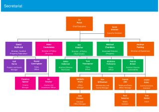
FGDC Coordination Group. FGDC Secretariat. Ken Shaffer FGDC Deputy Staff Director kmshaffer@fgdc.gov April 14, 2009. Staff Director Deputy Staff Director Senior Policy Advisor Senior Technical Advisor/Clearinghouse Coordinator Interagency Liaison/ Executive Secretary

FGDC Secretariat
E N D
Presentation Transcript
FGDC Coordination Group FGDC Secretariat Ken Shaffer FGDC Deputy Staff Director kmshaffer@fgdc.gov April 14, 2009
Staff Director Deputy Staff Director Senior Policy Advisor Senior Technical Advisor/Clearinghouse Coordinator Interagency Liaison/ Executive Secretary Geospatial LoB Program Manager Metadata Coordinator Standards Coordinator Training & Education/ Tribal Liaison Coordinator NSDI CAP Coordinator Webmaster Program Analyst Framework & Cooperating States Coordinator 2 Program Assistants Temporary Assistant 14 FTE, 1 Temp, 1 Contractor Secretariat Staff
Secretariat – A DOI Commitment • DOI has Leadership responsibility under OMB Circular A-16 • Secretariat is the primary support to carry out these A-16 responsibilities • DOI bureaus outreach through State liaisons, professional organizations, conferences, cross-agency activities • DOI funds all of the Secretariat activities as a component of their annual budget • Part of DOI’s investment in geospatial coordination and related activities • Geospatial LoB funds only pay for contract support staff supporting the Geospatial LoB activities
Secretariat’s Unique Perspective • Secretariat also focuses on external coordination and support (OMB A-16), national, international, cross-agency, cross-governmental • UNIQUE – Secretariat ‘perspective’ • Operate from an overall FGDC approach, not a DOI/USGS only approach • Supports the development and advancement of the NSDI • Secretariat has to take into account requirements from the FGDC Chair, Vice-chair, DOI, ExCom, Steering Committee, Coordination Group, NGAC – take all these drivers into account when setting the plans/operations for the year
Activities Support the NSDI • National Spatial Data Infrastructure • Affirmed and described in OMB Circular A-16 • Technology, policies, standards, human resources, and related activities necessary to acquire, process, distribute, use, maintain, and preserve spatial data • NSDI supports and advances the Global Spatial Data Infrastructure … international compatibility is an important aspect of the NSDI
National Spatial Data Infrastructure (NSDI) Components (A-16) • Data Themes • Metadata • National Spatial Data Clearinghouse • Standards • data, related processes, technology and organization • international standards and protocols • data development, documentation, exchange, and geospatial services • Collaborative Partnerships
Secretariat – Major Task Areas • Administrative Support to the FGDC • Chair and Vice-chair, Executive Committee, Steering Committee, Coordination Group • A-16 and Committee Charters • Program Management and Administration • NSDI Implementation • NSDI Components – Data Themes, Metadata, Clearinghouse, Standards, Collaborative Partnerships • Outreach, Communication, and Education • NSDI Components – Data Themes, Metadata, Clearinghouse, Standards, Collaborative Partnerships
Secretariat – Major Task Areas • Enterprise Architecture • NSDI Components – National Spatial Data Clearinghouse, Metadata, Standards • Geospatial Line of Business • OMB Managing Partner • NSDI Components – Data Themes, Metadata, Clearinghouse, Standards, Collaborative Partnerships • National Geospatial Advisory Committee Support • Federal Advisory Committee Act through DOI • NSDI Component – Collaborative Partnerships • GSDI and International Activities • NSDI Components – Collaborative Partnerships, Standards, Metadata
Administrative Support to the FGDC • OMB Circular A-16 revised • The DOI will provide administrative support to the FGDC • Executive Committee Charter • The FGDC Secretariat will provide staff support to the Executive Committee • NGAC Charter • Provides support to the DFO – FGDC Staff Director
Administrative Support to the FGDCcont’d • Steering Committee Charter • The DOI provides administrative support to the FGDC. FGDC Secretariat Staff will be assigned to support the Steering Committee to maximize productivity at meetings. Secretariat Staff responsibilities in support of the SC include: • Developing/vetting meeting agendas • Consolidating/distribution materials for SC review • Managing all admin requirements associated with scheduling and conducting meetings • Undertaking staff analysis, technical development and other activities on behalf of the CG
Administrative Support to the FGDCcont’d • Providing notification and read-ahead materials on issues requiring a vote. Advance materials on issues requiring a vote s/b provided one month in advance of meetings, if possible • Maintaining up-to-date membership lists for the SC, CG, subcommittees and working groups on the FGDC website. • Coordination Group Charter • Same as SC, plus – Working with CG members and FGDC subcommittees and working groups to identify business needs and challenges appropriate for discussion, and to develop appropriate discussion documentation
Reserves venues Develops agendas Ensures agency participation Presentation collection Attendance rosters Meeting materials Pre-briefs Minutes/Actions Posts to web site Vote preparation Updates FGDC calendar FGDC Executive Secretary Executive Committee, Steering Committee, Coordination Group
Committee Support cont’d • FGDC website management • FGDC Annual Report • Committee membership lists • Committee listservs • Communications
FGDC Initiatives Leadership and Support • Imagery for the Nation • Work Group Chairs (2) and participation • Meeting logistics/coordination • Recovery.gov • On-site development team member • GeoRecovery.gov Team lead • Weekly planning/coordination/meetings • Architecture quick analysis/input • Quick response efforts (with ExCom buy-in whenever possible) • Coordination Group Charter review/update • FGDC Operations Analysis
Subcommittees/Workgroups • FGDC Committee Support • FGDC Working Groups/Subcommittees • Work group leads (3) • Subcommittee leads (0) • Additional attendance varies based on activity • Secretariat typically fills vacancies by default • Trying to minimize these cases
Program Management/Admin. • Program within DOI under USGS • Management and administration – staff, equipment, agency reporting, budgeting, planning, required training, internal coordination, staff development, etc. • Materials printing/editing costs – Annual Reports, A-16 Supplemental editing, fact sheets, etc. • Contract, cooperative agreement management • Support DOI GIO • Research and material development • Quick response issues • Participate in DOI geospatial planning • Weekly coordination meetings • DOI/FGDC cross-representation in some instances
NSDI Implementation • CAP, 50 States Initiative • Collaborative Partnerships • Standards • Support Geodata.gov • CAP Category 5 – Building Data Stewardship for the National Map and NSDI
NSDI Cooperative Agreements Program (CAP) • Annual program to assist the geospatial community in implementing the NSDI • Provides cost-share funding • Since 1994 has provided $18mil to more than 600 NSDI related projects • 2008 – 20 across 6 categories • 2009 – 26 across 7 categories • Supported with 3 on-line training modules
Lead to sustainable projects Open to state/local/Tribal governments, academia, commercial, non-profit Introduce and extend the NSDI Implement proven solutions form metadata, clearinghouse, standards Encourage partnerships and leveraged resources Focus on infrastructure development, not data collation or GIS startup Produce measurable results NSDI CAP cont’d
CAP Tasks • Plan, coordinate, draft CAP announcement • Defines category goals, requirements, and outcomes • Identify category leads and proposal review teams • Facilitate/manages between category leads, Secretariat, grants officer, project primary investigators • Manage work plan development and implementation • Project reporting • Coordinates program kick-off workshops • Web information and projects database • Assess project deliverables and outcomes • Program assessment
50 States Initiative • CAP Category 3, cost-share for States • Develop and implement statewide strategic and business plans that will facilitate the coordination of programs, policies, technologies, and resources that enable the coordination, collection, documentation, discovery, distribution, exchange and maintenance of geospatial information in support of the NSDI. • 46 States have received awards to date • Annual kick-off meetings • Federal stakeholder’s workshop
National/FGDC Standards • FGDC Standards working group Chair and multiple participants • American National Standards Institute, (ANSI) • ASPRS – Standards Committee • CAP Category 6 – FGDC Endorsed Standards Development and Implementation Assistance and Outreach
Standards cont’d • Content Standard for Digital Geospatial Metadata and North American Profile (Metadata) • NAP profile development/review • NAP implementation guidance • CSDGM and NAP Training: intro, intermediate, train-the-trainer • ISO (and NAP) metadata editor review • Coordination/input: CAP recipients, FGDC WG, NOAA CDDC Trainers, Texas A&M, others
Standards cont’d • Advise standards developers on advancing through the FGDC Standards Process • Review proposals and draft standards • Develop policies and directives • Coordinate with: • FGDC SCs/WGs • Coordination Group • Federal agencies • Other organizations
Address data standard Hydrologic unit codes Standard for U.S. National Grid Federal Trails data standard Shoreline data content standard Metadata - NAP Wetlands Mapping standard Coastal and Marine Ecological Classification standard Cadastral data content standard Cultural Resources Geospatial Data content standard Standards – Recent/Current
Outreach, Communication, Education • Metadata, standards, cooperative agreements, Tribal initiatives, FGDC activities and initiatives • Education, outreach, workshops, training • Manage FGDC Website, calendar • Tribal Liaison • CAP Category 7 – Demonstration of Geospatial Data Partnerships Across Local, State, and Federal Government
Training/Support • Establishment and management of training MOUs • NSDI Awareness/metadata training/course materials/participation • DHS/FEMA (MOU) • Support - Emergency Management Framework for Tribal Government (E580) (2) • Support – Emergency Operations for Tribal Governments (1) • DOI/BLM • DOI/FWS (MOU) • GIS Intro for Conservation Professionals (3) • GIS Cartographic Design (1) • GPS Intro for Natural Resource Field Personnel (2) • NASA Training Proposed for ’09 • USGS/NBII Metadata workshop coordination • Two field offerings under MOU, TBD in ‘09
Training/Support cont’d • CAP Category 1 - Metadata Trainer and Outreach Assistance • EPA – Regional Tribal Meetings with Director’s office (IAG) • DOI/BIA – GIO and Training Center coordination • ESRI Conference – Tribal GIS Track moderation • Training statistics for FGDC and Partnerships
NSDI Training ProjectURL- http://www.fgdc.gov/training/nsdi-training-program/online-lessons • Provide Oversight • Mission and objectives • Outline annual program • Manage training contract/contractor • Coordinate content • States • FGDC staff • GOS staff
Committee Representation • Native View, GIS Tribal Organization (rep on NGAC) • National Congress of American Indians • DOI Deputy Member U.S. Board of Geographic Names • Help resolve contentious/offensive naming issues • USGS Director’s Office Tribal Liaison for GIO • USGS EROS, Tribal College Forum • USDA/USFS Native American Office • Position Navigation and Timing Exec Com
Attend if booth or presentation requested Focus on FGDC/GeoLob activities A primary outreach/education mechanism NSGIC (liaison) ASPRS URISA (liaison) AAG GSDI GITA’s (liaison) Education Committee ESRI (Fed Users, IU) Conferences
Outreach • FGDC Winter and Summary newsletters • USGS Eastern Region Newsletter support • University of Mary Washington focus group • GMU – School of Management coordination/GIS certification • Fort Valley State Summer Intern program (Richmond Office)
Enterprise Architecture • Geospatial One-Stop (GOS) technology integration support • Technical Standards support and collaboration • Geospatial LoB Technical Architecture WG lead
Geospatial One-Stop • Technology Integration support • Oversee EROS contractors who develop and support the GOS registry of services and quality-of-service assessment • NSDI Clearinghouse Network of over 180 metadata collections • Service-checker software • Technical support (counseling) provided to GOS publishers to resolve quality-of-service issues (3) • Category 2 CAP – Behind the Portal, Use of Geospatial One-Stop Map and Data Services
Technical Architecture/Standards • GeoLoB Technical Architecture WG lead • Co-author of the Federal Enterprise Architecture Geospatial Profile, V2.0 • Analyze, rate, award, oversee CAP category awards focused on demonstrating and testing web services, data standards, and SOA • CAP Category 4 – Enabling Use of Government Tabular Data in Geographic Context
Technical Architecture/Standards cont’d • Development/management of the GeoLoB/FGDC Geospatial Applications Registry (GEAR) for tracking geospatial software from all sources of geospatial applications
Geospatial Line of Business • Reporting responsibilities to DOI and OMB • Fulfill Managing Partner and administrative responsibilities • Geospatial LoB • Managing partner (1), managing partner team (3), work group Chairs (4), work group representatives (5), multiple participation depending on topic area
GeoLoB Leadership Roles • Program Manager • Oversight/coordination of work group activities • Manage the work group work plans process • Manage LoB PMO contractor support • Brought in for their subject matter expertise • Represent/present GeoLob program
GeoLob Activities • A-16 Supplemental Guidance draft/edit/review/endorsement, OMB … • Geospatial SmartBuy, Vendor’s day, drafting, RFQ, RFP, TEB, review … • ESRI Fed Users GeoLoB Showcase • FEA Geospatial Profile 2.0 • Geospatial Best Practices compilation
GeoLob Coordination/Support • FGDC Executive Committee, Steering Committee, Coordination Group, NGAC • SAOGIs and partner agency representatives • Joint Business Case (Exhibit 300) • MOU Funding agreements • GeoLob Quickplace management – LoB member information site, access management, work group spaces, documents and deliverables • FGDC Website Content • Communications/outreach – exhibits, factsheets, posters, event logistics, etc.
GeoLoB Reporting/Report Coord. • Quarterly OMB/DOI Reports • Quarterly DOI/Capital Planning EVM Reports • Quarterly Investment Review Board reports/presentations • Annual FGDC Report submission • Annual OMB LoB Benefits Report • Quarterly Strategic Plan milestones • Monthly invoice verification and payment approvals for the GeoLob contract
National Geospatial Advisory Committee (NGAC) Support • Designated Federal Officer – Staff Director • Administrative responsibilities to DOI and the FGDC • Support NGAC Chair and Vice-chair • Management/planning/logistics for meetings • Agendas, content, presentations, follow-up • Travel management for attendees • Planning and responses for NGAC recommendations • Support NGAC Subcommittees’ activities, meeting support, coordination of issues, etc.
NGAC Support, cont’d • Coordination with FGDC Chair, DOI, OS, OMB, partnership agencies • Manage membership nominations/ evaluation/appointment process • Manage NGAC website, Wiki, material/presentation distribution • Manage facilitation/meeting support contract • Fulfill DOI/GSA FACA reporting requirements • Post National Register announcements
Global Spatial Data Infrastructure (GSDI) and International Activities • A-16 and President’s Management Agenda • Global Spatial Data Infrastructure (GSDI) • Group on Earth Observations (GEO) and Global Earth Observing System-of-Systems architecture • International Standards • Joint Canadian and U.S. Spatial Data Infrastructure CAP project
GSDI • GSDI Board of Directors • GSDI Technical WG chair • Editor of “SDI Cookbook” • International consultative expert on SDI providing training and seminars for a variety of international programs (Africa, European Commission, UNGIWG, Australia, Indonesia, Malaysia, Japan)
GEO/GEOSS • Developing and documenting a common operational system-of-systems architecture for the GEO • Direct deployment of the GEOSS Component and Service Registry, a User Requirements Registry, and a GEOSS metadata clearinghouse search facility • Support Architecture Implementation Pilots in partnership with OGC to test common infrastructure
Standards - International • Federal agencies will develop their international spatial data • In compliance with international voluntary consensus standards, as defined by Circular A-119 • Active participation in voluntary consensus standards bodies • Advisor on appropriate standards/practices for SDIs • OGC - Architecture and Catalogue Working Groups and Planning Committee
International Standards Organizations Activities • Represent FGDC on INCITS Technical Committee L1, Geographic Information Systems • INCITS L1 is the means by which the U.S. participates in national (ANSI) and international (ISO) standardization activities • Serve as the International Representative, INCITS L1 • Alternates (4) representatives to ANSI INCITS L1 • Chair U.S. Technical Advisory Group meeting • Serve as National expert to ISO TC 211 • Represent U.S. at ISO Technical Committee 211 meetings & plenary