Download
1 / 10
120 likes | 297 Vues
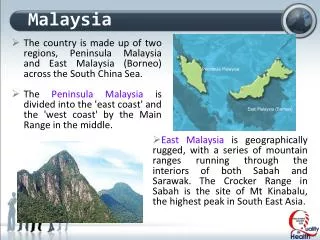
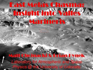
S. East Melas Chasma: Insight into Valles Marineris. Matt Chojnacki & Brian Hynek Laboratory for Atmospheric and Space Physics @ the University of Colorado. Hebes Chasma. Ganges Chasma. Ophir Chasma. Candor Chasma. Melas Chasma. Corprates Chasma. EMC Landing Site Motivation.

E N D
S East Melas Chasma: Insight into Valles Marineris Matt Chojnacki & Brian Hynek Laboratory for Atmospheric and Space Physics @ the University of Colorado
Hebes Chasma Ganges Chasma Ophir Chasma Candor Chasma Melas Chasma Corprates Chasma
EMC Landing Site Motivation EMC EDL Site Characteristics • Insight into to aqueously altered Interior layered deposits (ILDs) • Light and dark-toned VM floor material associated with topographic lows (standing water? layered floor?) • Possible inverted fluvial features • Excavated floor material from nearby ~2km crater • Nearby wall material lending clues to stratigraphy of the upper crust • Atmospheric observations • 20km ellipse centered on 290.45°E -11.62°N • Mean elevation= -5829 m • Alternative ellipses ~22km W and ~21km SE
Engineering Parameter Requirement EMC Candidate Landing Site Slopes 2 to 5km length scale ≤ 3° 2km (avg/max) 3km 4km 5km 0.42°/1.45° 0.39°/0.9° 0.36°/1.0° 0.3°/0.8° 20 to 40m length scale ≤ 15° THEMIS VIS/MOC NA show a smooth unmantled surface 5m length scale ≤ 15° MOC NA shows relatively smooth surface free of aeolian features Rock abundance (IRTM) ~10% 12.1% Winds Steady state horizontal ≤ 30m/s Average of 18m/s over 3 sols (8am-8pm local time) [1] Steady state vertical ≤ 10m/s At altitudes of 0 to 10 km above the surface [1] Radar reflectivity Ka band reflective and >0.01 Relatively low albedo and high thermal inertia imply radar reflective surface. Load bearing surface TES thermal inertia >100 Jm-2 s-0.5K-1 244 J m-2 s-0.5 K-1 albedo <0.25 0.13 Table 1: Summary of engineering requirements [1] Rafkin, S. (2004) unpublished data.
0.7 km V16641003 V08679002 20 km 2.9 km M1300309 M2001176
3 km 500 m Poly-hydrated Sulfates as detected by OMEGA 14 km E2300516
Summary for EMC • EDL, trafficability & PP look good and have flexibility • Help determine the Valles Marineris water history present and past • Interior layered deposits and hydrated minerals • At -5km a large atmospheric column & radiation environment to observe • Amazing observations of Mars that will inspire future scientist/explorers
Layered Sedimentary Rocks Outcrops, No Floats No/Little Dust Low Energy Depositional Sedimentary Facies X Interior Layered Deposits X X ~0.96 TES Dust Index X Poly-hydrated Sulfates Matt Golombek’s “Keys” to being a high priority MSL landing sight East Melas Chasma
References • Gendrin, A., et al., (2005), Sulfates in Martian Layered Terrains: The OMEGA/Mars Express View, Science, 307, 1587-1591. • Lucchitta, K.B., Geologic Map of Ophir and Central Candor Chasmata (MTM-05072) of Mars, U.S. Geologic Survey., MAP I-2568, 1999. • Quantin, C., P et al., (2005), Sulfate Deposits identified by OMEGA in Melas Chasma, Lunar Planet. Sci., XXXVI, Abstract 1789. • Rafkin S. C., (2004) unpublished data. • Ruff, S. and P. Christensen, (2003), A SPECTRALLY-BASED GLOBAL DUST COVER INDEX FOR MARS FROM THERMAL EMISSION SPECTROMETER DATA., First Landing Site Workshop for MER 2003, Abstract 9026. • Witbeck, N. E., K. L. Tanaka, and D. H. Scott (1991), Geologic Map of the Valles Marineris region, Mars, MAP I-2010, U.S. Geologic Survey.