3D buildings
Explore the latest publications and projects on using laser scanner data for 3D topography applications, including building reconstruction and road analysis. Details on levels of detail, advancements, and interest from various departments and institutes.

3D buildings
E N D
Presentation Transcript
3D buildings Sander Oude Elberink Status 6-3-08
Contents • Publications Nov 07- march 08 • 3D Enschede • 2008 – 2009
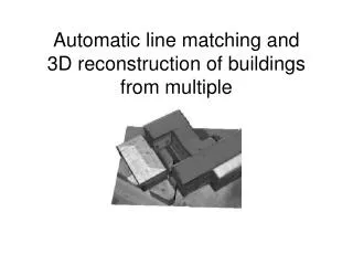
Publications accepted • 3D Geo-Info • Oude Elberink, S. (2008) Re - using laser scanner data in applications for 3D topography. In: Advances in 3D geoinformation systems / ed. by ed. by P. van Oosterom, S. Zlatanova, F. Penninga and E. Fendel. Berlin : Springer, 2008. (Lecture Notes in Geoinformation and Cartography) ISBN 978-3-540-72134-5 pp. 87-99. • Photogrammetric Journal of Finland • "Quality Analysis of 3D Road Reconstruction“ • Accepted with minor revisions, resubmitted February 2008 • ISPRS Congress (July 2008) • Oude Elberink, S., 2008. Problems in Automated Building Reconstruction based on Dense Airborne Laser Scanning Data. International Archives of Photogrammetry, Remote Sensing and Spatial Information Sciences, 37 (part 3A). • GeoInformatics Magazine (March 2008) • Re-using laser data / Hergebruik van laseraltimetrie data
Publications • VI Matrix (Februari 2008) • Poster + explanation 3D Acquistion • Annual report ITC • The Photogrammetric Record • 3D Reconstruction of infrastructural objects • In review phase • GIS Magazine (July 2008) • Hergebruik van laseraltimetrie data
Level of Detail (acc. Kolbe/CityGML) • LOD0 –Regional model • 2.5D Digital Terrain Model • LOD1 –City/ Site model • “block model“ w/o roof structures • LOD2 –City/ Site model • textured, differentiated roof structures • LOD3 –City/ Site model • Detailed architecture model • LOD4 –Interior model • “walkable“ architecture models
“Do you have … in 3D?” • Interest from other’s: • Application departments within ITC • ITC Etalagemiddag (what ITC does for (local) governments) • Institute of Photogrammetry, Hannover (&asks for data PCP) • Students from UT (estimate # inhabitants using 3D geo-info) • Joris Bak, Hanneke van Giffen (HvU)