Download
1 / 5
50 likes | 147 Vues
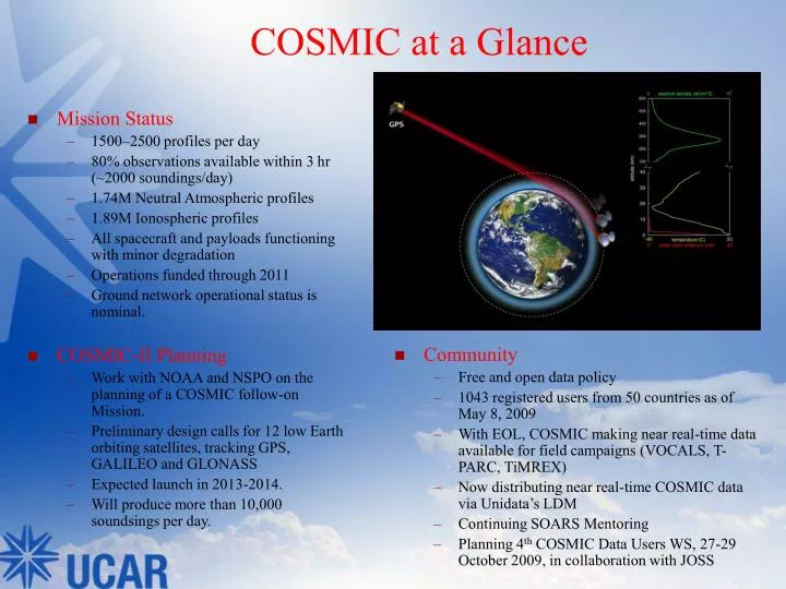
COSMIC at a Glance. Mission Status 1500–2500 profiles per day 80% observations available within 3 hr (~2000 soundings/day) 1.74M Neutral Atmospheric profiles 1.89M Ionospheric profiles All spacecraft and payloads functioning with minor degradation Operations funded through 2011

E N D
COSMIC at a Glance • Mission Status • 1500–2500 profiles per day • 80% observations available within 3 hr (~2000 soundings/day) • 1.74M Neutral Atmospheric profiles • 1.89M Ionospheric profiles • All spacecraft and payloads functioning with minor degradation • Operations funded through 2011 • Ground network operational status is nominal. • COSMIC-II Planning • Work with NOAA and NSPO on the planning of a COSMIC follow-on Mission. • Preliminary design calls for 12 low Earth orbiting satellites, tracking GPS, GALILEO and GLONASS • Expected launch in 2013-2014. • Will produce more than 10,000 soundsings per day. • Community • Free and open data policy • 1043 registered users from 50 countries as of May 8, 2009 • With EOL, COSMIC making near real-time data available for field campaigns (VOCALS, T-PARC, TiMREX) • Now distributing near real-time COSMIC data via Unidata’s LDM • Continuing SOARS Mentoring • Planning 4th COSMIC Data Users WS, 27-29 October 2009, in collaboration with JOSS
COSMIC Soundings to Date Daily COSMIC profile count throughout the mission. The red color shows the soundings from real-time processing. The green color shows the soundings from post-processing, which often is able to generate more sounding profiles but lags 1-2 months behind the real-time products.
Observing System Simulation Experiments • We performed observing system simulation experiments to assess the potential impact of COSMIC-II on typhoon prediction (based on Typhoon Shanshan 2006). • When compared with the “control experiment” which does not assimilate GPS RO data, we find sizable impact of COSMIC and COSMIC-II. • Different orbit configuration would result in different data density distribution, and they would have varied impact on typhoon track and intensity forecast. • It would be desirable to have enhanced sounding data density over the tropics. COSMIC - 6 x 72o COSMIC-IIA - 8 x 72o + 4 x 24o COSMIC-IIB - 12 x 72o
Science Highlight: Soil Moisture and Snow Depth Retrievals with GPS Collaborative research between COSMIC and K. Larson of CU-ASEN has led to development of new algorithms to measure soil moisture (top) and snow depth (bottom left) using geodetic ground based GPS instrumentation. New NSF proposal has been submitted to improve and apply this technique to a subset of the more than 2000 permanently operating GPS stations in the US. Larson, et. al, (2008), Use of GPS receivers as a soil moisture network for water cycle studies, Geophys. Res. Lett., 35, L24405, doi:10.1029/2008GL036013
Community Infrastructure Proposal: Advanced Real-Time GNSS Network for Atmosphere and Ocean Science • COSMIC is developing a plan to create a national network of streaming GPS stations for meteorology applications. The plan will include the following new capabilities: • PW updates with frequency and latency similar to WSR-88D network (<10 minutes) • Deployment of GPS instrumentation on fixed and mobile platforms in the Gulf of Mexico. • Collaborative effort includes participants from October 2008 Ocean Platforms workshop. • Contact J. Braun if other universities interested in participation.