DEWOOS: Delaware Estuary Watershed to Ocean Observing System
270 likes | 287 Vues
DEWOOS aims to develop an effective observing program for the Delaware Estuary Watershed, River, and Bay to meet national and regional IOOS goals, ensuring safety, resource management, national security, and more. The Delaware Estuary is a key urban region in the US with vital ecological significance and various environmental challenges. Existing programs and potential upgrades like improved river and bay real-time monitoring, additional sensor sites, and automated gliders can enhance DEWOOS.

DEWOOS: Delaware Estuary Watershed to Ocean Observing System
E N D
Presentation Transcript
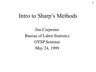
DEWOOS – A Concept That Should Be an Effective Program Jonathan H. Sharp College of Marine and Earth Studies University of Delaware Delaware Estuary Science Conference Cape May - 23 January 2007
Contributors to DEWOOS Concept: • Bob Tudor (DRBC) • Danielle Kreeger (Partnerhsip for Delaware Estuary) • Scott Glenn (IMCS, Rutgers) • Jawed Hameedi (NOAA) • John Kraeuter (Haskin Shellfish Lab, Rutgers) • Pete Rowe (NJ Sea Grant Extension Program) • Ed Santoro (DRBC) • Eric Vowinkel (USGS) • Mohsen Badiey (CMES, University of Delaware) • Ann Faulds (PA Sea Grant) • Chris Sommerfield (CMES, University of Delaware) • Mike Weinstien (NJ Marine Sciences Consortium)
DEWOOS – The Delaware Estuary Watershed to Ocean Observing System • Purpose: To develop an effective observing program for the Estuary of the Delaware Watershed, River, and Bay that will advance the national and regional IOOS goals: • Detecting and forecasting oceanic components of climate variability • Facilitating safe and efficient marine operations • Ensuring national security • Managing resources for sustainable use • Preserving and restoring healthy marine ecosystems • Mitigating natural hazards • Ensuring public health
Importance of Delaware Estuary Fourth largest urban region in US Drinking water supply to over 16 million people One of largest oil refinery and chemical industry centers of country Second largest petrochemical port in US Major electrical generation capacity including large nuclear plants Once major US center for sturgeon, shad Center for horseshoe crab population – associated migratory shorebirds
Head of tide at Trenton, NJ Urban region with over 5 million people 100 km long tidal river – one of world’s largest tidal freshwater estuaries 120 km long saline stretch into Delaware Bay Delaware Bay with little water, terreginous, or anthropogenic inputs GIS-based map by Yoana Voynova from USGS database
Delaware Estuary Land Cover Heavily urbanized tidal river Marsh surrounded saline bay
Delaware Estuary Watershed Watershed (33,254 km2) Water surface (2,070 km2) Tidal river (91 km2) Water inputs: Delaware R – 58% Schuylkill R – 14% saline region – 11% NOAA NEEA areas USGS flows
Upper tidal river – clear, composite agricultural and municipal inputs from fall line Urban river – relatively clear, local massive municipal inputs Turbidity maximum – resuspension of historical TSS inputs – strong light limitation Mid-bay – grading from turbid to clear, relatively high nutrients grading to limitation Lower bay – very clear, nutrient-limited
Advantages of Delaware Estuary Over 80% of water inflow in freshwater river Most anthropogenic inputs in urban river Most terrigenous inputs at two gauging stations Marshes buffer lower estuary terriginous inputs Delaware Bay simple geometrically Bay opens in regular funnel shape One tidal length long Dominant river channel focuses flow Thus: Can characterize much with input gauging and center estuary transect monitoring
Environmental Quality and Ecosystem Health Issues Freshwater inflow Oxygen depletion Nutrient enrichment and biogeochemical processes Hydrodynamics and sedimentation Contaminant sources and transport Estuary-atmosphere interaction Ecologically significant species Tidal wetlands
What Measurement Capabilities Do We Have? DRBC Boat Run Monitoring – Consistent discrete station sampling along axis of estuary since 1967 – water quality parameters USGS gauging stations (Trenton, Philadelphia, and smaller) with daily water discharge plus some chemical and suspended sediment measurements NOAA PORTS – several locations with continuous physical and meteorological parameters DBOS – oceanographic and meteorological continuous measurements on Fourteen Foot Lighthouse (UD) CODAR – two to three lower bay continuous current profiling stations
http://tidesandcurrents.noaa.gov/dbports/dbports.shtml?port=dbhttp://tidesandcurrents.noaa.gov/dbports/dbports.shtml?port=db
Other Existing Programs USGS – other NWIS sites, Delaware River monitors Additional DRBC sampling programs NJ DEP Real time sites in Delaware Bay DE DNREC Real time sites in Delaware Bay My research sampling program (Sharp, UD) Delaware Environmental Observing System, DEOS (UD Department of Geography) Kirchman Microbial Observatory, Luther test ORION observatory Others?
Additional Programs to Add or Upgrade Improved river and bay real time monitoring – more sites, more sensors (add to USGS sites?) More light house telemetered sites Improved or added sites with depth profiling capability Ferry Monitoring AUVs – automated remotely directed “gliders”
Example of DEWOOS Potential and Needs for Improvement in Future Dissolved oxygen – important water quality – ecosystem parameter Good example of use of extant programs: DRBC boat run transects USGS gauging stations and other NWIS stations Research vessel surface mapping Example of need for better integration and access of data from various programs Example of need for additional measurements
Delaware Estuary Oxygen Dynamics Formerly, urban Delaware River had extreme oxygen depletion in summer – eliminated with improved sewage treatment. Presently, in spite of very high concentrations of nutrients, primary production is not elevated and there is no excess algal production. Could riverine oxygen demand increase? Delaware Bay is well-mixed in summer with no bottom water isolation from stratification; bay is stratified for 2-8 weeks in spring (temperatures very cold, no oxygen depletion). Could hydrological change cause summer stratification and lead to summer hypoxia?
Urban river region had extreme oxygen depletion in summer in the past. DO concentration in river (near Philadelphia Airport) from DRBC Boat Run monitoring, 1967-2004.
Oxygen sag in summer extended along much of urban river down into the upper part of Delaware Bay. Average July-August oxygen from DRBC Boat Run data over past 4 decades. Dashed line = 3.5 mg/L.
1955 hurricane 1936 ice storm Delaware River discharge from 1912-2006 – 3 of 5 largest discharge events in Sept 2004, April 2005, June 2006. Could this cause warm weather stratification?
Discharge at Trenton and Conductivity at Reedy Island – summer 2006
Increased production from large discharge? Bottom water oxygen?
Next Steps for DEWOOS Need to develop easy access web page: Capture and format data from existing programs Interpret data enough to be able to make illustrations Put data in GIS-based map format for access Develop links to existing web sites so future data will also be accessible Add more Bay continuous stations, including depth